December 2011
|
December 2011 // Volume 49 // Number 6 // Ideas at Work // v49-6iw1


Place-Based Learning and Mobile Technology
Abstract
When delivered on a mobile device, interpretive tours of a locale afford powerful learning experiences. As mobile devices become more powerful, content for these devices that is individualized and location-specific has become more common. In light of this trend, Oregon State University Extension developed a GPS-enabled iPhone tree tour application. This article discusses lessons learned during the design, development, and evaluation of the application and suggests locale-specific instructional content delivered on a mobile device can be an effective instructional approach for Extension educators.
Introduction
Mobile computing has gained mass adoption as more people abandon their workstations and laptops in favor of Internet-ready smartphones that offer ever-increasing speed and functionality. With billions of mobile network subscribers around the world, the need to create instructional content for mobile platforms is an obvious step towards reaching new and existing Extension audiences. Although there is little research about how Extension might deliver instructional content on mobile devices, Extension agents have experimented with wireless laptop systems to perform remote field diagnostic work (Bequette, 2006) and have also used laptops to perform field-based pest management (Resel & Arnold, 2010).
In light of more ubiquitous mobile device ownership and ever-increasing access to wireless networks, we might ask ourselves: What type of Extension content is suitable for mobile platforms, and how do we create content that has instructional value for this audience? While there are many different ways to format and distribute mobile content, we felt that Place-based Learning was an ideal framework to help design mobile device content that is instructional and specific to a locale.
Place-based Learning focuses on the physical, environmental, and cultural characteristics of a specific location or milieu during a learning activity (Sobel, 2004) and encourages a tactile, multimodal approach to learning that promotes autonomy while a learner explores the unique features of a physical environment. This instructional framework has great potential when developing instructional content for Extension audiences because many Extension topics are linked to physical locations—the learning is often embedded in location. Fortunately, mobile devices often provide location services (GPS), application support, augmented reality capability, and other features that leverage one's physical location and help interpret or navigate a locale.
OSU Campus Tree Tour iPhone Application
Based on the high market share of iPhone users in 2009 and early 2010, we chose the iPhone as our delivery platform. Although our department lacked the skill set to develop a smartphone application, we desired to be as involved as possible in the development process and therefore hired two student interns from the Oregon State University New Media Communications Program. We worked closely with the students on the design, development, evaluation, and distribution of the application, but ultimately, they did much of the "heavy lifting" and provided programming support.
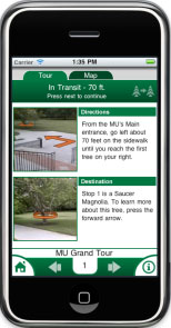
The application directs a tour participant from one campus tree to another while providing information about each tree. Initially, we had hoped that the GPS device would be accurate enough to provide directional information for users, but after some testing, we found that the accuracy of the GPS values were too difficult to rely on when the user was walking. Consequently, we added GPS location as a supporting feature of the application. To direct the user from tree to tree, we provided photos of each stop and included cues to help users locate the tree using objects in the physical environment as reference points, i.e., lampposts, walkways, buildings, etc. The use of "augmented reality" markers (arrows, circles) to highlight directions (Figure 1) helps orient users relative to each specific tree.
Figure 1.
Photos with "Augmented Reality" Markup
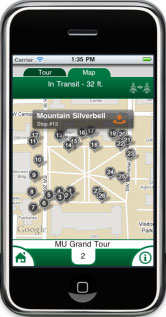
Since GPS-based location was included as a secondary means to find location relative to a tree stop, we chose to augment the walking tour with a GPS-enabled map that would allow the user to see his current location relative to other trees in a tour. This map (Figure 2) allows user to "jump" from stop to stop and provides a "quick glance" of tree names. Each tree icon is linked to our tree repository where one can view the comprehensive list of trees found in all tours.
Figure 2.
GPS-Enabled Map of Trees
How Long Does It Take to Develop a Smart Phone Application?
Ultimately, development effort is connected to project budget, complexity, and development pace, so each project will have its own characteristics. Overall, our project took about 5 months of full-time work for the students and perhaps 1 month of full-time work for the instructional designer and project manager. However, it is important to note that the first few months involved significant "ramp up time" for the students to learn the programming language and that a "spin off" version of the application for a different topic would take considerably less time. Developing mobile applications using HTML, CSS, and Javascript (or jQuery) can take much less time, assuming that the developers are already fluent in these Web languages and the application itself is less dependent on graphical objects.
Resources Needed to Develop a Smart Phone Application
Although there are thousands of iPhone applications, very few have been developed by Extension and embrace a Place-based Learning approach. We gave special attention to graphical conventions and the usability of the application in light of our audience and the form factor of a mobile device. While many of the initial challenges were technical (learning a programming language), some of the most important considerations were often instructional in nature. For instance, using innovative approaches to connect tree information with a specific location was challenging where physical objects were both the focus of learning and the cues for directing the learner from tree to tree. This meant that using clear navigational schemes was essential, especially on the smaller iPhone display. While the following list is not exhaustive, it captures the primary resources needed to develop a smart phone application.
- Time
- Money
- Coding/programming expertise
- Licensing agreements for content and platform
- Subject matter expert(s)
- Administrative support
- Partnerships to assist with distribution and marketing
- Authoring tools and hardware
- A viable maintenance and sustainability plan
- Instructional design knowledge
- User interest and need
- Imagination
User Evaluation
Surveys helped assess the effectiveness of the tree tour. A small-scale survey was conducted by 10 individuals (six of the 10 testers were iPhone owners). The individuals were asked to complete eight to 10 tree stops using the application and then answer questions about their experience. The testers were also asked to talk aloud their thoughts about the tour. Each respondent spent approximately 30-45 minutes using the application outdoors and then completed the survey. An evaluator accompanied each tester during the tree tour and took notes as the tester commented on the experience. The evaluators were asked to record any statements made by the testers and were asked to withhold any potential assistance. Table 1 shows the results of the survey, which was administered after the tour was completed.
| Total Number of Responses | ||||
| Question | Agree | Disagree | Neutral | Comments |
| Was the application easy to use? | 10 | 0 | 0 | |
| Was the navigation effective? | 10 | 0 | 0 | Unit distances unhelpful; relative distances
and landmark references preferred. Scrolling elements need to be more clearly indicated. |
| Do you think this would appeal to visitors and campus guests? | 8 | 0 | 2 | Maybe if it had more stories, history, medicinal uses, myths, etc... |
| Are you still interested in this application? | 8 | 2 | 0 | I don't own an iPhone, but would be interested
if similar application were developed for my phone. More interested in other different kinds of tours. |
| Did you learn something of value? | 9 | 1 | 0 | Would like to see wider range of content.
I already knew much of the information offered. |
| Do you think this approach could be used for other similar topics? | 10 | 0 | 0 | |
The most helpful input from this testing was related to navigational conventions. Initially, we included the distance between tree stops but found that this distracted our users from our visual cues that directed the user from tree to tree. We added these visual markers to the photos using arrows and brightly colored circles (Figure 1). Not surprisingly, those users who already owned iPhones expected more navigational flexibility in terms of being able to click and zoom on photos. However, non-iPhone owners still found the overall navigational scheme easy to use.
Most users skipped the tutorial and preferred orienting themselves to the navigational conventions while using the tool for the first time. This led us to believe that any essential directional items would need to be displayed once via a forced pop-up screen, which we did.
Summary
Oregon State University Extension Service developed this application internally to better understand the requirements of developing smartphone applications. Lessons learned improve future efforts to develop mobile content and provide us with opportunities to share with other Extension groups nationwide.
References
Bequette, B. (2006). Mobile wireless Internet video: Bringing the specialist into the field remotely. Journal of Extension [On-line], 44(3) Article 3TOT1. Available at: http://www.joe.org/joe/2006june/tt1.php
Resel, E., & Arnold, S. (2010). Electronic integrated pest management program: An educational resource for Extension and agricultural producers. Journal of Extension [On-line], 48(6) Article 6IAW2. Available at: http://www.joe.org/joe/2010december/iw2.php
Sobel, D. (2004). Place-based education: Connecting classrooms and communities. Great Barrington, MA: Orion Society.