April 2019
|
April 2019 // Volume 57 // Number 2 // Tools of the Trade // v57-2tt5


Interactive Online Tool for Educating the Public About Landscape Conservation
Abstract
Landscape-scale conservation planning performed in a systematic and transparent manner is becoming more common as it is increasingly evident that ecological processes are being affected at large spatial scales. The Appalachian Landscape Conservation Cooperative undertook a 15-state landscape conservation planning project, resulting in a landscape conservation design called NatureScape. To facilitate NatureScape's implementation by groups and individuals participating in on-the-ground landscape conservation, we developed an online decision support tool. This tool has the potential to assist Extension services in delivering research-based information to varied stakeholders as they make land use decisions.
Introduction
Among Extension's constituencies are groups focused on establishing new conservation lands. Increasingly, groups working to establish conservation lands rely on maps generated through systematic conservation planning—that is, landscape conservation design (LCD)—that help prioritize where landscape conservation efforts should occur. Translating the science underlying LCD into transparent and actionable tools can be challenging. We developed an interactive online decision support tool that will aid Extension services in disseminating information and educating the public about landscape conservation.
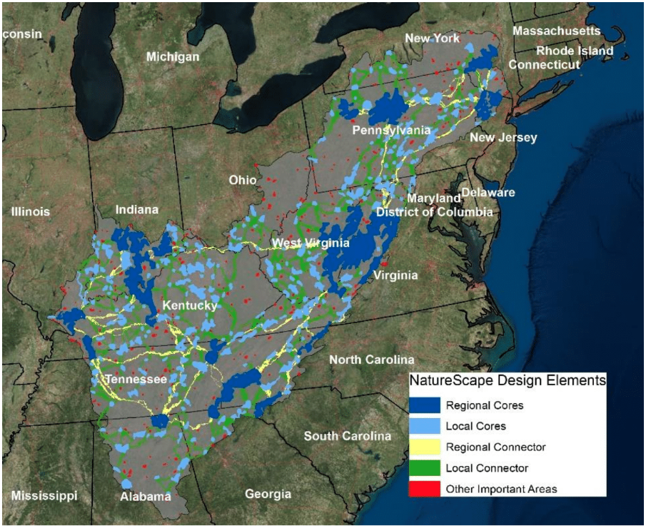
The Appalachian Landscape Conservation Cooperative (AppLCC) undertook an LCD exercise to provide a holistic plan for conservation in a 15-state region (Figure 1) (Leonard, Baldwin, & Hanks, 2017). The AppLCC branded this LCD NatureScape. Technical details of and methodologies behind NatureScape were published in Scientific Reports (Leonard et al., 2017). However, to facilitate understanding and implementation of NatureScape by regional conservation practitioners, who often have more localized conservation intentions, we developed the NatureScape online decision support tool, which is hosted by the U.S. Fish and Wildlife Service at https://www.fws.gov/selectspecies/. On-the-ground conservation efforts are often based on the ability of conservation groups to impress on stakeholders the conservation value of specific geographic areas. Conservation planning and mapping processes are complex, involving many geographic inputs and algorithms, and simple presentations of the results are needed to engage those most affected. The online tool we present here provides a tangible interface between an identified geographic area and its importance to conservation goals. The data translation approach we use is unique but is replicable in regions for which similar data are available.
Figure 1.
Map of the Appalachian Landscape Conservation Cooperative (AppLCC) 15-State Region Displaying Landscape Conservation Design Elements Derived from the AppLCC's Conservation Planning Exercise
What Is the NatureScape Online Decision Support Tool?
Description of the Tool
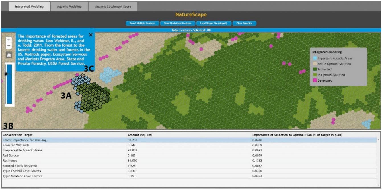
NatureScape is a map-based online decision support tool developed to communicate conservation priorities that arose from the AppLCC LCD mapping exercise addressing both aquatic and terrestrial goals (Leonard et al., 2017). Such tools provide regional context to conservation planning priorities. NatureScape's home screen (Figure 2) provides an overview of the region's geography; through selection of areas within the region, information on local conservation priorities is displayed. Three tabs at the top of the window allow users to work with an integrated model, an aquatic model, or an aquatic catchment score, depending on their interests and needs. Zooming in to a smaller geographic extent, users can select an area of interest (e.g., individual 1-km hexagons, a polygon, or an uploaded shapefile) (see section 3A in Figure 3). The tool displays a table describing conservation targets represented in the selected area, how much total area within the selection each conservation target contributes, and the overall importance of the area for any given target (see section 3B in Figure 3). Selection of a conservation target listed in the table produces a description of the selected target and identification of the data source used in NatureScape (see section 3C in Figure 3).
Figure 2.
NatureScape Home Page
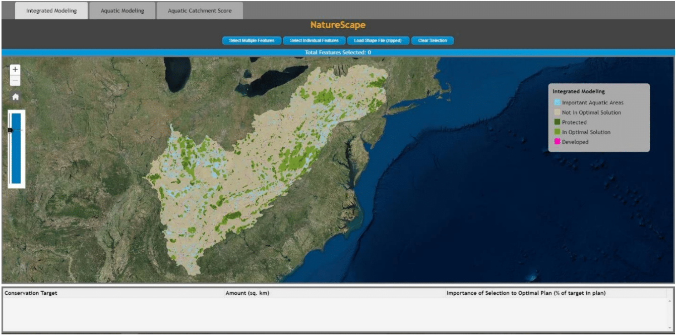
Figure 3.
Example of NatureScape in Action
Integration of Stakeholder Conservation Interests into the Tool
The 15-state region is high in aquatic diversity, and stakeholders wanted planning products that showed conservation priorities based on aquatic diversity alone as well as those that emerged when considered in combination with terrestrial priorities. To address these concerns in the online tool, we converted two map sets from the design into geodatabases; one integrated aquatic and terrestrial ecosystems, and the other focused on aquatic targets only. We used ArcGIS Version 10.5 to create the necessary symbology and visual representation for each map. Large study areas necessitate an interface that quickly loads maps while still facilitating user interaction. To meet this need, we created raster tile caches from each of the maps to act as the main user interface. Each map's actual data are overlaid as an invisible layer. As a user selects features on the map, the underlying data are loaded and displayed. To make the raster caches publicly accessible, we published them to an ArcGIS Enterprise (Version 10.5.1) server. Finally, we created a JavaScript-based web application to display the maps and user interface. Other regions may have different conservation priorities, but the principles of integration of multiple map layers apply anywhere.
Examples of Potential Uses of the NatureScape Online Tool for Extension
Systematic conservation planning aims to identify areas on the landscape that are important to conservation, which can be variable and depend on the concerns and interests of the stakeholders involved, the region and ecosystems present, and data availability. NatureScape, an example of an online delivery tool for conservation planning information, can be adapted by Extension services to convey mapped conservation values associated with land parcels. NatureScape covers a vast expanse but the underlying principles can be applied at various scales. For example, bobwhite quail are dependent on intact, connected, and functional early successional ecosystems (South Carolina Department of Natural Resources, 2013). The ability to show a landowner visually (i.e., via an online map) how his or her property, if managed properly, can contribute to the persistence of bobwhite populations may convince the landowner to participate in management practices that support healthy, connected early successional ecosystems (e.g., prescribed burning). Other online mapping tool examples include the U.S. Fish and Wildlife Service's conservation blueprint of the South Atlantic region (https://blueprint.southatlanticlcc.org/) and DataBasin (https://databasin.org/). Extension personnel active in translating spatial conservation planning to citizens may examine these examples and others and choose what approach best suits their needs.
Summary
Future conservation success will depend on sound decisions about management actions taken on private lands (Baldwin & Leonard, 2015), and much land is threatened with urbanization (Mockrin et al., 2018). Decisions taken as to which areas have conservation priority should be based on best available scientific information and should be communicated in a transparent, accessible, and actionable manner. Maps appeal to the desire for easily digestible visual information and are valuable for communication by Extension agents (Abd-Elraham, Duryea, Dix, & Perry, 2010). NatureScape, an online tool for disseminating mapped conservation priority information, can be adapted for any region, spatial scale, or set of priorities. Extension services provide the public unbiased, research-based information (U.S. Department of Agriculture, National Institute of Food and Agriculture, n.d.). Conservation priority mapping, a rapidly expanding field, is often supported by public funds. Online mapping tools such as NatureScape can help refine and deliver the plethora of maps being derived from conservation data.
References
Abd-Elrahman, A., Duryea, M., Dix, M., & Perry, J. (2010). Online project mapping with researcher community input. Journal of Extension, 48(3), Article 3FEA3. Available at: https://www.joe.org/joe/2010june/a3.php
Baldwin, R. F., & Leonard, P. B. (2015). Interacting social and environmental predictors for the spatial distribution of conservation lands. PLOS One, 10(10), e0140540. Retrieved from https://journals.plos.org/plosone/article?id=10.1371/journal.pone.0140540
Leonard, P. B., Baldwin, R. F., & Hanks, R. D. (2017). Landscape-scale conservation design across biotic realms: Sequential integration of aquatic and terrestrial landscapes. Scientific Reports, 7, Article number 14556. Retrieved from https://www.nature.com/articles/s41598-017-15304-w
Mockrin, M. H., Steward, S. I., Matonis, M. S., Johnson, K. M., Hammer, R. B., & Radeloff, V. C. (2018). Sprawling and diverse: The changing U. S. population and implications for public lands in the 21st century. Journal of Environmental Management, 215, 153–165.
South Carolina Department of Natural Resources. (2013). Northern bobwhite habitat restoration in South Carolina. Retrieved from http://www.dnr.sc.gov/wildlife/quail/HabitRestorationinSC_ChallengesandOpportunities.pdf
U.S. Department of Agriculture, National Institute of Food and Agriculture. (n.d.). Extension. Retrieved March 29, 2018, from https://nifa.usda.gov/extension