October 2016
|
October 2016 // Volume 54 // Number 5 // Ideas at Work // v54-5iw3


Enhancing Extension and Research Activities Through the Use of Web GIS
Abstract
There have been numerous efforts aimed at improving geographic literacy in order to address societal challenges. Extension educators can use geographic information system (GIS) technology to help their clients cultivate spatial thinking skills and solve problems. Researchers can use it to model relationships and better answer questions. A program at Prairie View A&M University involves the use of virtual, field, and story map activities associated with Web GIS (online mapping) to expose participants to plant species identification and engage them in spatial thinking. We describe that program and demonstrate the utility of Web GIS as a tool for integrating experiential learning in agro-environmental sciences.
Introduction
Geographic information system (GIS) technology uses hardware and computer software to capture, store, analyze, and present geographic locations, features, and boundaries (Gerard, 1990). The increased use of GIS in Extension has been credited with encouraging improved spatial reasoning, enhancing educational experiences, and inspiring general awareness about the value of mapping applications (Sinton, 2009). Its impact on spatial reasoning alone is significant: As Harvey, Kne, and Manson (2013) said, "Spatial thinking is a core element of learning across the curriculum" ("Year One," para. 3).
In 2010, we started the program series Geocaching Agro-Environmental Sciences Project (GASP) for Knowledge. The overall goal of the program series is to use modern technologies to help participants better understand and address agro-environmental issues. In the first program, GASP 1, participants located 20 sites with hand-held global positioning system (GPS) units and answered questions related to agro-environmental sciences issues associated with each site. Subsequently, GASP 2 improved on GASP 1 by using online mapping (Web GIS) to enhance participants' understanding of environmental, ecological, and agricultural systems. The intent of this article is to elucidate the value of the GASP 2 project and the applicability of Web GIS in Extension.
What Is Web GIS?
Web GIS allows users to publish maps on servers for consumption outside an organization (ArcGIS Resources, 2013). If a mapmaker or developer does not have access to a local ArcGIS for Server installation, ArcGIS.com provides an alternative. (ArcGIS for Server is a software product from Esri, a company that supplies GIS software and applications.) The alternative to a local ArcGIS for Server installation is a cloud-based portal that connects a plethora of web content for collaboration, analysis, sharing, development, and publishing of web-based applications (ArcGIS Resources, 2013).
Although desktop GIS programs continue to be popular, the use of web technologies such as Google Earth to create GIS applications has grown tremendously (Gewin, 2004). Web-based applications are particularly popular because they
- facilitate multiple users simultaneously;
- are available 24 hours a day, 7 days a week;
- are cross platform; and
- are user friendly.
Accordingly, Web GIS directly addresses two of the major barriers to technology adoption: ease of use and access to resources. This circumstance presents opportunities for Extension personnel to apply Web GIS in programming activities. For example, Web GIS resources can be used to expose 4-H members firsthand to use of emerging technologies, helping them develop essential science and math skills (Johnson, McGee, Campbell, & Hays, 2013) that can be applied in agro-environmental sciences, engineering, business, and other fields. Web maps referred to in this article were developed through the use of Esri ArcGIS Online tools, templates, and apps. Tools used in GIS are critical to skill building for geospatial applications (Table 1).
| Tool | Geospatial applications |
| Summarize data | Calculate lengths, areas; conduct basic descriptive statistics |
| Find locations | Apply facility allocation; determine how locations relate to each other |
| Apply data enrichment | Explore demographic data and statistics |
| Analyze patterns | Analyze spatial patterns, such as density |
| Use proximity | Identify places that are closest to known locations; create areas of equal distance from one another |
| Manage data | Stack layers to determine how multiple data sets fit together; create new data sets from existing data |
| Note. Perform analysis tools. Adapted from ArcGIS Online Help. Retrieved March 10, 2016, from http://doc.arcgis.com/en/arcgis-online/use-maps/perform-analysis.htm. | |
Benefits of Web GIS in Agro-environmental Sciences
Extension Education
Brown (2007) pointed out that educators in schools and 4-H programs could enhance their curricula by including local spatial explorations. Web GIS applications are ideal for introducing the fundamentals of GIS to 4-H groups. Abd-Elrahman, Duryea, Dix, and Perry (2010) described Internet mapping solutions as ideal and powerful tools for gathering feedback when delivering Extension programs. Kerski (2008) argued that although there are several tools for teaching spatial literacy, GIS is a perfect tool for analyzing the earth and its peoples if instructors use it in novel ways. Several applications for GIS are useful across Extension program areas (Table 2).
| Extension program area | Applicability |
| 4-H and youth development | Social media maps, summer camp applications (plant identification), coordinate systems, data collection |
| Agriculture and natural resources | Land use planning, tracking of animals, ecotourism, site selection and allocation, plant species identification |
| Family and consumer sciences | Demographic analysis, neighborhood analysis (e.g., sustainable neighborhood analysis protocol), mapping of food places and community gardens |
| Community and economic development | Creation of 3-D applications, damage assessment, business expansion, reporting, scenario planning |
Research
The use of GIS and related technologies for field data collection, soil analysis, and water quality monitoring can lead to applications in land management, environmental analysis, real-time analysis, and dissemination of information. Researchers can create spatial decision support systems to improve decision making and further support Extension programs.
GASP 2 Activities
GASP 2 comprises a virtual activity, a field activity, and a story map activity related to features on the Prairie View A&M University research farm. Table 3 provides details of and durations for each activity. The information included in this article is based on completing GASP 2 with a volunteer group of scientists, faculty, and staff.
| Activity | Details | Duration (approximate number of hours) |
| Virtual | Complete a pretest; learn how to create ArcGIS.com accounts and the basics of navigating ArcGIS.com (inserting base maps, zoom, pan, working with layers); learn about features across the landscape; visualize information spatially; use pop-ups; complete paper-based exercise related to map pop-ups; engage in discussion on features within the zones; complete a posttest; learn basic computing skills | 2 |
| Field | Learn the basics about coordinate systems, way point finding, elevation, and data collection with GPS units; discuss landscape features that may not have been evident in the virtual activity (dependent on season); facilitate environmental science experiential learning about weeds, terrain, and animal life | 4 |
| Story map | Better appreciate landscape features by making spatial connections; identify elements in the specific agro-environmental story; develop competencies using geospatial technologies | 1 |
Virtual Activity
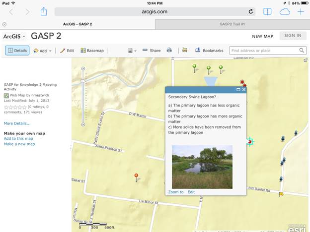
We recommend that participants be given a pretest measuring preexisting knowledge about agro-environmental sciences. ArcGIS.com was used to create web maps for the virtual activity. The virtual exercise (Figure 1) introduces participants to four learning zones for gathering knowledge about various aspects of integrated agro-ecological systems. They are (a) hay meadow and riparian, (b) pasture management, (c) animal production, and (d) farm operations. Zones are identified by unique map markers and are associated with multiple trails. Participants click on markers to reveal pop-ups that include multiple-choice questions and photos. Answer sheets are provided for the exercise, and participants engage in discussion about each zone. The information in this article is based on a trail that traverses three of the learning zones. To conclude the exercise, a posttest can be administered to determine participants' learning levels and identify ways to improve the exercise.
Figure 1.
GASP 2 Virtual Exercise on www.arcgis.com
Field Activity
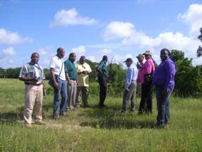
Participants use GPS units to visit some of the zones they encounter in the virtual activity (Figure 2). Various zone sites are preloaded in GPS units as way points along a trail that traverses the hay meadow and riparian, pasture management, and farm operations zones. The trail is 1.59 mi and has seven sites. Participants stop at each site and discuss the surroundings. This experiential exercise enhances comprehension of agro-ecological systems, stimulates rich discussion, and enables participants to experience a real-world version of the virtual activity. The activity concludes with a reflection time exercise (Table 4).
Figure 2.
Scientists and Professional Staff Using GPS in the GASP 2 Field Activity
| Audience | Reflection time activities |
| Faculty, scientists, Extension staff, and other adult audiences |
|
| 4-H'ers and other students |
|
Story Map Activity
Participants return to the computer lab for the story map activity (Figure 3), which is based on the trail walk experienced during the field activity (Figure 4). This activity further enhances comprehension of agro-ecological systems and stimulates additional rich discussion as participants already have experienced the virtual exercise and completed the field activity.
Figure 3.
Story Map (http://tamu.maps.arcgis.com/apps/MapTour/index.html?appid=edc6575cb1d04edb834199a0452ae640&webmap=5c0151e06f0847289651d81e37198435)
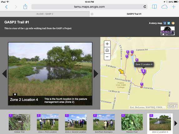
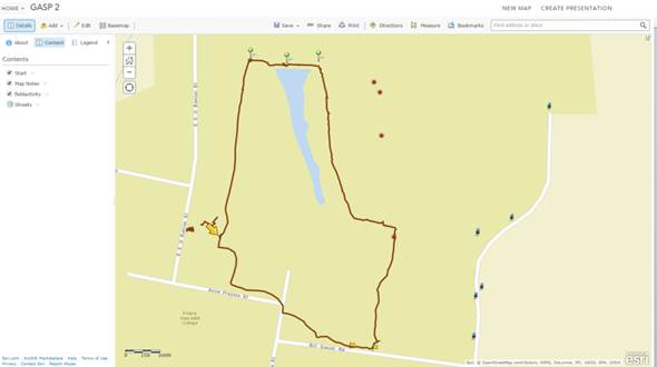
Figure 4.
GASP 2 Walking Trail
Summary
GASP 2 introduces the value of Web GIS as a tool in Extension education and research activities. It reinforces the utility of Web GIS by demonstrating how GIS-GPS and related technologies can be used to design and deliver programs that foster experiential learning opportunities in agro-environmental sciences.
We suggest that collaborations among research scientists, professional staff, and Extension personnel would encourage broader use of geospatial technologies in Extension. Examples include the creation of real-world applications to inform and enhance the development of resource inventories, community asset maps, curricula, and socioeconomic analysis. Because Web GIS technologies are dynamic, establishing these various technology linkages requires a certain level of knowledge. Thus, future work will include the creation of a technical manual on how to replicate GASP 2.
References
Abd-Elrahman, A., Duryea, M., Dix, M., & Perry, J. (2010). Online project mapping with researcher community input. Journal of Extension, 48(3) Article 3FEA3. Available at: https://www.joe.org/joe/2010june/a3.php
ArcGIS Resources. (2013). Welcome to ArcGIS.com Help. Retrieved from http://resources.arcgis.com/en/help/arcgisonline/index.html#//010q00000002000000
Brown, S. C. (2007). The Brown County online GIS: An example of a multi-agency collaborative mapping system. Journal of Extension, 45(5) Article 5TOT3. Available at: https://www.joe.org/joe/2007october/tt3.php
Gerard, L. (1990). Education in geographical information systems. In H. J. Scholten & J. Stillwell (Eds.), Geographical information systems for urban and regional planning (pp. 191–201). Netherlands: Kluwer Academic Publishers.
Gewin, V. (2004). Mapping opportunities. Nature, 427(6072), 376–377, ISSN 0028-0836.
Harvey, F., Kne, L., & Manson, S. (2013). U-spatial: A consortium for the spatial university. ArcNews, 34(4), Winter 2012/2013.
Johnson, L., McGee, J., Campbell, J., & Hays, A. (2013). The Virginia geocoin adventure: An experiential geospatial learning activity. Journal of Extension, 51(4) Article 41AW4. Available at: https://www.joe.org/joe/2013august/iw4.php
Kerski, J. J. (2008). The role of GIS in digital earth education. International Journal of Digital Earth, 1(4), 326–346.
Sinton, D. S. (2009). Roles for GIS within higher education. Journal of Geography in Higher Education, 33(51), S7–S16. doi:10.1080/03098260903034046