April 2015
|
April 2015 // Volume 53 // Number 2 // Research In Brief // v53-2rb6


Persistence Wins: Long-Term Agricultural Conservation Outreach Pays Off
Abstract
This article discusses the lesson learned from an Extension, state, and federal agency coordinated water quality project that was formally started in 1995. In the project, educational programing was provided, high risk areas were identified, and BMPs were implemented on these areas. The net result of BMP implementation was a 38% improvement in South Dakota Bad River water quality. This improvement was attributed to Extension and others providing leadership on: 1) the development of local learning communities and 2) identification and implementing BMP's in high risk areas. This work demonstrates that Extension can make a difference.
Introduction
Extension can help farmers and ranchers improve water quality and land use sustainability by coordinating activities between different organizations, assisting local groups overcome roadblocks, and facilitating discussions between individuals, organizations, and state and federal agencies. We believe that the first step at producing measurable impacts is to develop trust and local advocates. The second step is to identify and target activities to high risk areas (Wortmann et al., 2008), while the third step is to facilitate active communication between all collaborators.
In spite of the numerous projects that have attempted to produce measureable water quality improvements, few have done so. The lack of success generally revolves around the following (Rogers & Showmaker, 1971; Harrington, Krupnick, & Peskin, 1985; Nowak 1987; Osmond et al., 2012; Tyndall & Roesch, 2014):
- The lack of "trust" between the farmer/rancher and the project;
- A poor fit between recommended practices and the producers current cultural practices;
- High labor and financial cost;
- Non-targeting activities to high risk zones;
- A communication breakdown;
- High project management turnover; and
- The proposed practices are perceived to have limited beneficial impacts and improvements over the old approaches.
Producing measureable water quality impacts may take decades, and research suggests that corrective activities must be focused on high risk areas (Wortmann et al., 2008). The project reported here was based on a water quality risk assessment conducted by the South Dakota Department of Environment & Natural Resources (SD DENR) in the Bad River Watershed of western South Dakota (Thelen, 2004). The initial assessment identified rangelands as the sediment source for the Bad River. However, this assessment did not consider the impact of a wheat fallow system in the upland areas on water cycling across the entire watershed. Miller (2014) reported that a high risk area in this watershed was the transition zone between the crop and rangeland systems. Fortunately, SD Extension anticipated these results and helped create a no-tillage learning group (http://www.sdnotill.com/index.htm) and actively encouraged no-tillage adoption in the upland areas.
The Bad River Watershed Case Study
The case study used for this assessment was the South Dakota Bad River Watershed. Funding was provided by the USDA Conservation Effects Assessment Program (Weltz et al., 2008). This study assessed if coordinated educational programing could increase BMP adoption and produce measureable water quality improvements. The Bad River Watershed project used a holistic approach that relied on focused demonstration trials, producer learning groups, organized educational programming, and targeted governmental assistance.
The Bad River Watershed has an area of 3,173 miles2 or 2,030,720 acres and contains about 36% cropland and 63% rangeland (Thelen & Noeske, 1996). It can be separated into upland (53%) with slopes ranging from 0-15%, river breaks (32%) with slopes ranging from 16-45%, badlands (10%), and valleys (5%) (Thelen & Noeske, 1996; Figure 1). The Bad River originates in the Badlands near Wall, South Dakota, and flows to the Missouri River, where it discharges into Lake Sharpe. Native vegetation in the watershed is mixed grass prairie with open woodland along the main stem of the Bad River. Upland areas are used in crop production, hay production, and pasture, whereas the dominant management in the river breaks is rangelands.
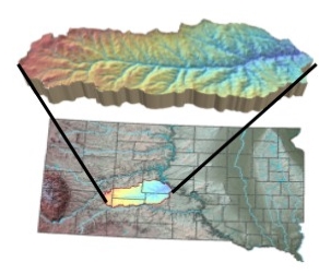
Figure 1.
The Bad River Watershed in South Dakota (produced by Kurt Reitsma)
Rangeland productivity decreases from east to west and coincides with rainfall (Rigge, Smart, Wylie, Gilmanov, & Johnson, 2013). The region average wheat yield ranges from 15 to over 40 bu/acre, while the average corn yield ranges from 20 to 90 bu/acre. Across the watershed, range and crop productivity is water limited. Fertilizers are generally applied to the croplands but not on rangelands. Since 1948, the U.S. Army Corps of Engineers (COE) has measured sediment and water flow at a gauging station located near the mouth of the Bad River. Of the 3.2 million tons of sediment that is discharged from the Bad River Watershed into Lake Sharp annually, approximately 80% is from gully formation (Thelen, 2004).
Resources Involved in the Project
Educational Programing
Over the past 20 years, learning groups, on-farm studies, field days, workshops, implementing improved practices, and leadership training has been conducted within and surrounding the Bad River Watershed. These events were sponsored by many different entities (Thelen & Noeske, 1996; EPA, 2012) including:
- South Dakota State University (SDSU) Extension,
- South Dakota Experiment Station,
- County Conservation Districts,
- SD DENR,
- South Dakota Game, Fish & Parks Department (SD GF&P),
- USDA Farm Service Agency (FSA),
- USDA Natural Resources Conservation Service (NRCS),
- South Dakota Department of Agriculture, U.S. Geological Survey (USGS),
- U.S. Fish & Wildlife Service (USFWS),
- North Central Resource Conservation and Development,
- Pheasants Forever, and
- South Dakota Wheat Commission
Each organization had slightly different responsibilities. For example, 1) the South Dakota Wheat Commission, SDSU Extension, SDSU Experiment Station, and USDA-NRCS sponsored no-tillage field demonstration studies; 2) EPA, NRCS, and SD DENR provided rangeland BMP adoption incentives with funding from EPA-319, EPA-Pollution Prevention Incentive Strategies (PPIS), and EQIP; 3) SD Extension and the Bootstraps program helped create learning groups with funds from EPA-319 and PPIS; and 4) the SDSU-AES and SDSU Extension sponsored range and crop management production workshops, tours, and demonstration studies. These educational programs were augmented by founding the Dakota Lakes Research Farm in 1990. An outcome of the Bootstraps program was the creation of learning groups (Sobrero & Jayaratne, 2014) and the eventual creation of the South Dakota Grassland Coalition (http://www.sdgrass.org/). This rancher-lead organization sponsored grazing schools, ranch tours, workshops, and demonstration studies and facilitated one-on-one discussions between ranchers, Extension personnel, and scientists.
Targeted Federal Assistance
Targeted federal assistance from EPA-319, NRCS-EQIP, and USDA-NIFA programs provided funding (approximately 9 million dollars) to implement range management BMPs. The implementation projects included installing cross fencing, livestock waterers, erosion control structures, and facilitated proper grazing practices on rangeland in sub-watersheds of Powel Creek, Ash Creek, Willow Creek, Dry Run Creek, and numerous tributaries (Thelen, 2004).
Quantifying Improvements
Changes in rancher behavior and improvements in water quality were determined using surveys and Bad River water quality field measurements. Details on the survey are available in Stover et al. (2012).
Rangeland BMP Adoption Survey
The effectiveness of the Bad River rangeland educational program was assessed by sending surveys to 71 participants who were involved in best management practice implementation and 252 farmers/ranchers not involved in the program (Stover et al., 2012). Of the mailed surveys, 27 (38% return rate) were returned from prior participants, and 96 (38% return rate) were returned from the control group.
Cropland BMP Adoption Survey
From 1985 to 2010, 1928 production soil sample surveys from the west central region of South Dakota were completed. These surveys in combination with the analytical results from soil samples were used to develop fertilizer recommendations (Clay et al., 2012).
Quantifying Sediment Loading
Average annualized suspended sediment concentration (mg/L) and water discharge (m3/sec) from the Bad River was evaluated from data collected by the USGS water gauging station located at the mouth of the Bad River from 1972-2011 (USGS, 2013). At the gauging station flow and sediment concentrations were measured using USGS protocols. Data was analyzed for pre-BMP years (1972-1994) and post-BMP years (1995-2011) using a paired t-test. Sediment transport during "average" flow rates was determined by omitting daily flow values of <2 m3/sec (low flows) and >12 m3/sec (high flows).
Assessment Results: Rangeland BMP Adoption
Rangeland BMPs were targeted toward the river breaks in the lower basin of Bad River Watershed, where the soils are very erosive (Table 1). It was estimated that BMPs were implemented on 77-90% of the ranches in several sub-basins within this region. The ranchers who returned the survey indicated that they were very satisfied and that most of the BMPs have been maintained since the completion of the project in 2006 (Table 1). These findings are in agreement with a regional water quality survey, where 79, 76, and 59% of South Dakota respondents thought that livestock management, better agricultural practices, and improved grazing was very or extremely important in improving water quality (Clay et al., 2007).
| Implemented | Maintained | Satisfaction1 | |
| Best Management Practice | # producers | # producers | (1-5 scale) |
| Pipelines | 11 | 8 | 4.11 |
| Water tanks | 11 | 9 | 4 |
| Cross fencing | 10 | 7 | 4.11 |
| Proper grazing use | 9 | 7 | 4.11 |
| Deferred grazing | 8 | 5 | 4.14 |
| Livestock pond | 8 | 6 | 4 |
| Wells | 8 | 7 | 3.8 |
| Planned grazing system | 7 | 5 | 4.12 |
| Livestock windbreak shelters | 7 | 4 | 4.28 |
| Windbreak structure | 6 | 5 | 4.57 |
| Creek crossing | 4 | 4 | 4.83 |
| Erosion control structure | 3 | 3 | 4.67 |
| Water spreader | 2 | 1 | 3.5 |
| Wildlife habitat development | 2 | 2 | 4.5 |
| Riparian vegetation | 2 | 2 | 5 |
| 1The possible answers to the satisfaction question were 1 = being very dissatisfied, 2 = dissatisfied, 3= neutral, 4 =satisfied, and 5 = very satisfied. | |||
A comparison between the survey results from the participants and the control group had subtle differences. For example, both groups indicated that erosion and sedimentation are an important problem (76-77% replied yes). However, of those involved in rangeland implementation projects, 44% thought that water quality could be improved by adopting BMPs, whereas 77% of the control group thought that sedimentation could be controlled by BMPs. This difference is intriguing and warrants further study. This comparison highlights the need to distribute a final report to the project participants.
Assessment Results: No-tillage Adoption on Croplands
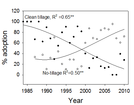
In this watershed, crop production was concentrated in the upland areas. Historically, management used in these areas was a wheat fallow rotation (Clay et al., 2014), and tillage was used to prepare a seed-bed and control weeds during the fallow year. The fallow saved water for wheat production that was planted every other year. The survey showed that prior to 1998 most farmers used tillage to prepare a seed bed (Figure 2). However, the survey also showed that between 1998 and 2000 management changed from a tilled system to a no-tilled system. This change was linked to the release of Roundup® ready crops, an active Extension program that demonstrated the technology, organized no-tillage learning groups, and the establishment of the Dakota Lakes Research farm that focused on no-tillage adoption. Associated with this management change was a corresponding increase in agricultural intensification from producing a crop every 2 years to producing a crop every year. Based on this survey, approximately 72% of the farmers used no-tillage in 2010. Related research has shown that adopting no-tillage increases water infiltration and reduces runoff and the amount of the water feeding the gullies (Verbree, Duiker, & Kleinman, 2010).
Figure 2.
No-tillage Adoption from 1985 to 2010 Across the West Central Region of South Dakota
Assessment Results: Quantifying Sediment Reduction
Over the study period, sediment loading was highest during high rainfall years and lowest during low rainfall years (Zhoui, Li, Nkedi-Kizza, & O'Hair, 2003). To separate climatic variability from BMP adoption, the data set was sorted according to water flow (Table 2). This sorting showed that after 1995 the sediment load during normal flow periods (>2 and <12 m3/sec decreased 38%. This reduction is attributed to SDSU Extension providing leadership on the creation of learning groups, which resulted in the wide-scale adoption of no-tillage in the upland areas and NRCS, EPA, and SD DENR funding range implementation projects on the pasturelands in the river breaks.
| All data | All data | Flow rate > 2 and < 12 m3/sec | ||
| Year | Sediment | Flow | Sediment | Flow |
| g/L | m3/sec | g/L | m3/sec | |
| 1972-1994 | 1.86 | 2.98 | 1.9 | 5.23 |
| 1995-2011 | 1.32 | 7.69 | 1.17 | 4.81 |
| p-value | 0.034 | 0.033 | 0.0417 | 0.765 |
In this watershed, Thelen (2004) reported that 80% of the sediment transported to the Bad River was linked to gully formation. Based on this assessment, stabilizing the gullies was identified as a high priority. Gully enlargement is the result of several interacting factors, including the amount of water feeding the existing gullies, the effectiveness of the control structures within the gully, and vegetation within the gully. This project addressed all three. Between 1998 and 2000 no-tillage was rapidly adopted across the region. The voluntary adoption of no-tillage when combined with switching from producing a crop every 2 years to producing a crop every year increased evapotranspiration and reduced runoff and the amount of water feeding the gullies (Linstrom et al., 1994). In addition, by adopting deferred grazing at targeted rangeland locations, the channels started to recover (Vande Kamp, 2012; Vande Kamp, Rigge, Troelstrup, Smart & Wylie, 2013).
Summary and Conclusions
A holistic approach was used to educate and implement conservation practices on rangeland and cropland in the Bad River Watershed. In critical rangeland areas, ranchers were involved in funded implementation projects, while in upland areas farmers' voluntary adopted no-tillage. Analysis showed that an important high risk area was the transition zones between crops on upland locations and pasturelands on the river breaks. This problem area was addressed by encouraging farmers to voluntarily switch from a wheat fallow rotation to a no-tillage continuous wheat rotation and incentivizing the installation of erosion control structures to deferred grazing practices by ranchers. Analysis showed that these efforts result was a 38% improvement in the Bad River water quality. Other studies have produced similar results (Heathwaite, Sharpley, Bechmann, & Peskin, 2005; Nowak 1987; Nowak & Cabot, 2004). Based on Osmond et al. (2012) we suggest that unless the conservation practices are placed in critical areas, producing measureable impacts is unlikely. Successful adoption of BMPs didn't happen overnight, and we believe it was the result of common message and careful planning. Extension played an important role in producing these outcomes.
References
Clay, D., Clay, S. Reitsma, K. Dunn, B. Smart, A. Carlson, G. Horvath, D. & Stone. J. (2014) Does the conversion of grasslands to row crop production in semi-arid areas threaten global food security? Global Food Security. Retrieved from: http://www.sciencedirect.com/science/journal/22119124/3 (accessed September 12, 2014)
Clay, D. E., Chang, J., Clay, S. A, Stone, J., Gelderman, R., Carlson, C. G., Reitsma, K., Jones, M., Janssen, L., & Schumacher, T. (2012). Corn yields and no-tillage affects carbon sequestration and carbon footprints. Agronomy Journal 104:763-770.
Clay, D., Ren, C., Reese, C., Waskom, R., Bauder, J., Mesner, N., Seelig, B., Paige, G., Reddy, K., Neibauer, M., & Mahler, R. (2007). People's perceptions, impacts, and willingness to utilize different learning opportunities designed to improve water quality. Journal of Natural Resource Life Science Education 363:36-44.
EPA. (2012). Water: Nonpoint source success stories – South Dakota. Retrieved from: http://water.epa.gov/polwaste/nps/success319/SD.cfm
Harrington, W., Krupnick, A. J., & Peskin, H. M. (1985). Policies for nonpoint source water pollution control. Journal of Soil and Water Conservation 40:27-32.
Heathwaite, L., Sharpley, A., Bechmann, M., & Rekolainen, S. (2005). Assessing the risk and magnitude of agricultural nonpoint source phosphorus pollution. p. 981-2021. Sims and Sharpley (eds), In Phosphorus: Agriculture and the environment. Agronomy monograph # 46. ASA, SSAJ, CSSA, Madison WI.
Lindstrom, M. J., Schumacher T. E., Congo, N. P., & Blecha, N. P. (1994) Management consideration for returning CRP land to crop production. Journal of Soil and Water Conservation 49:420-425.
Miller D. ( 2014). Calculating erosion potential using IFSAR elevation models in two major watersheds in South Dakota. MS Thesis, South Dakota State University, Brookings SD.
Nowak, P. J. (1987). The adoption of conservation technologies: economic and diffusion explanations. Rural Sociology 42:208-220.
Nowak, P., & P.E. Cabot (2004) The human dimension of resource management programs. Journal of Soil and Water Conservation 59(6):128A-135A.
Osmond, D., Meals, D., Hoag, D., Arabi, M., Luloff, A., Jennings, G., McFarland, M. Spooner, J., Sharpley, A., & Line, D. (2012). Improving conservation practices programming to protect water quality in agricultural watersheds: Lessons learned from the National Institute of Food and Agriculture-Conservation Effects Assessment Project. Journal of Soil and Water Conservation 67:122-127.
Rigge, M., Smart, A., Wylie, B., Gilmanov, T., & Johnson, P. (2013). Linking phenology and biomass productivity in South Dakota mixed-grass prairie. Rangeland Ecology and Management 66:579-587.
Rogers, E., & Showmaker, F. (1971). Communication of innovations: A cross-cultural approach, 2nd edition, New York, Free Press.
Sobrero, P., & Jayaratne, K. S. U. (2014). Engaging learners through collaborative learning: Leadership development of county extension directors and lessons learned. Journal of Extension [On-line], 52(2) Article 2FEA2. Available at: http://www.joe.org/joe/2014april/a2.php
Stover, R.G., Parvez, M. R., Janssen, L. Burkhard, S. Clay, D., Mousel, E. Reitsma, K. D., Smart, A. & Troelstrup, N. (2012) Executive summary: Social and economic attitudes toward conservation practices in the Bad River Basin of South Dakota. Retrieved from: http://www.sdstate.edu/soc/rlcdc/i-o/upload/Social-and-Economic-Attitudes-toward-Conservation.pdf
Thelen, J. P., & Noeske, L. (1996). Bad River phase II water quality project: Final report. South Dakota Department of Environment and Natural Resources, Pierre, SD. 64p.
Thelen, J. (2004). Section 319 nonpoint pollution control program watershed project final: Bad River phase III water quality project. South Dakota of Environment and Natural Resources, Pierre, SD. 76 p. Retrieved from: http://denr.sd.gov/dfta/wp/wqprojects/tmdl_badriver05impIII.pdf
Tyndall, J. & Roesch, G. L. (2014). Agricultural water quality BMPs: A standardized approach to financial analysis. Journal of Extension [On-line], 52(3) Article 3FEA10. Available at: http://www.joe.org/joe/2014june/a10.php
USGS. (2013). National water information system: Webinterface. 06441500 Bad River near Fort Pierre, SD. Retrieved from: http://waterdata.usgs.gov/nwis/annual?referred_module=sw&site_no=06441500&por_06441500_8=1413065,80154,8,
1972,2012&start_dt=1972&end_dt=2012&year_type=W&format=html_table&
date_format=YYYY-MM-DD&rdb_compression=file&submitted_form=parameter_selection_list
Vande Kamp, K. L. (2012). Implications of best management practices on channel evolution within the Bad River watershed: West central South Dakota. South Dakota State University MS thesis, Brookings SD.
Vande Kamp, K., Rigge M., Troelstrup, N. H., Smart, A .J. & Wylie, B. (2013) Detecting channel riparian vegetation response to best-management-practices implementation in ephemeral streams with the use of spot high-resolution-visible imagery. Rangeland Ecology and Management 66:63-70.
Verbree, D. A., Duiker, S. W., & Kleinman, P. J. (2010). Runoff losses of sediment and phosphorus from no-till and cultivated soil and dairy manure. Journal of Environ Quality 39:1750-1750.
Weltz, M.A., Jolley, L., Nearing, M., Stone, J., Goodrich, D. Spaeth, K., Kiniry, J., Arnold, J., Bubenheim, D., Hernandez, M., & Wei, H. (2008). Assessing the benefits of grazing land conservation practices. Journal of Soil and Water Conservation 63:214-217. doi:10.2489/jswc.63.6.214A.
Wortmann, C. S., Helmers, M., Devlin, D., Anderson, S., Tranti, T., Tomer, M., & Frees, L. (2008). Targeting of watershed management practices for water quality protection. Nebraska University Extension publication RP195. Retrieved from: http://www.ianrpubs.unl.edu/live/rp195/build/rp195.pdf
Zhoui, M., Li, Y. C., Nkedi-Kizza, P., & O'Hair, S. K. (2003). Endosulfan losses through runoff and leaching from calcareous gravel or mare soils. Vadose Zone Journal 2:231-238.