December 2014
|
December 2014 // Volume 52 // Number 6 // Ideas at Work // v52-6iw1


Google Earth for Landowners: Insights from Hands-On Workshops
Abstract
Google Earth is an accessible, user-friendly GIS that can help landowners in their management planning. I offered hands-on Google Earth workshops to landowners to teach skills, including mapmaking, length and area measurement, and database management. Workshop participants were surveyed at least 6 months following workshop completion, and learning outcomes as well as landowner application of Google Earth were assessed. Participants made significant gains in Google Earth skill level immediately following workshop completion, but longer-term skill retention was variable. Most participants found Google Earth to be a valuable tool for a variety of land management purposes.
Introduction
Maps and remote sensing have long been an integral part of natural resources management. While hand-drawn maps and hardcopy aerial photographs have largely been replaced by computer-based systems, landowners still use geographic information to plan management activities, monitor changes to their property, and share ideas with others. Larger forestry and agricultural entities have been quick to adopt geographic information system (GIS) technologies (Rongxia, Bettinger, Danskin, & Hayashi, 2007), but many smaller producers are unable to do the same because of the large investments in time and money associated with a traditional GIS. The need to plan, monitor, and share ideas about land, though, is common to both large and small owners. Indeed, certification systems employed by many smaller-scale producers, including the American Tree Farm System, Forest Stewardship Council, and USDA Organic, all require management plans with maps. The need for a user-friendly and universally discernable GIS exists across the spectrum of land-based enterprises served by Cooperative Extension.
Google Earth (GE) (Google Inc., 2013) is a freely available commercial GIS product that can be easily adapted to use in land management planning. GE allows users to view archived aerial and satellite imagery and also to create, save, and share geographic features. While the mapping and analysis tools of GE are less powerful than a full-featured commercial GIS, it will usually meet the needs for smaller-scale producers.
To help meet the need for a user-friendly GIS, I offered a series of GE workshops to landowners in Oregon. In this article, I describe the workshops as well as the results of a program evaluation and impact assessment.
Google Earth Workshop
I offered six 1.5-hour introductory GE workshops throughout Oregon in 2011-2013. The goal of the workshops was to give landowners experience with relevant GE skills including:
- Locating and viewing aerial imagery of one's property;
- Mapping features such as roads, fields, and management units;
- Saving and sharing features created in GE;
- Measuring lengths and areas of features;
- Viewing historical imagery of one's property; and
- Importing GPS data into GE.
I demonstrated the GE features listed above while participants followed along on their computers. Some sessions benefited by having a floating assistant who checked in with participants to address individual questions. Participants were provided a "Google Earth for Landowners" guide describing in detail the GE procedures covered in the workshop. Workshops were kept relatively small (12-20 participants) so the instructor was able to field questions and comments from participants. Two of the workshops included additional time (1.5 hours) for participants to practice using the GE tools and create a management map of their property.
Evaluation and Impact Assessment Results
I surveyed participants via email at least 6 months after each workshop. Ninety-four (out of 107 total) participants had provided valid email addresses and of these, 43 responded to the survey for a response rate of 46%.
Age
Survey respondents were older than average for Oregon landowners (Butler, 2008) but were typical in age for Extension program participants (Table 1).
| Age Group | Count | % |
| 15 to 24 years | 0 | 0 |
| 25 to 34 years | 3 | 7 |
| 35 to 44 years | 3 | 7 |
| 45 to 54 years | 0 | 0 |
| 55 to 64 years | 12 | 28 |
| 65 to 74 years | 25 | 58 |
| 75 to 84 years | 0 | 0 |
| 85 years or over | 0 | 0 |
GE Skill
Self-reported GE skill level of participants increased an average of 35 points (on a scale of 0 to 100) immediately following the workshop but since completion of the workshop decreased (on average) four points (Table 2) (Figure 1). This slight reduction in average skill is comprised of 22 participants reporting an increase in skill over time, 7seven reporting little or no change (fewer than five points plus or minus), and 14 reporting a decrease (Figure 2).
| Min. Reported Value | Max. Reported Value | Average Value | |
| Before Attending the Workshop | 0 | 60 | 22 |
| Immediately After the Workshop | 5 | 90 | 57 |
| Time of Survey | 4 | 91 | 53 |
Figure 1.
Histogram of Participant Self-Reported GE Skill Level Change from Before Attending the Workshop to Immediately Following the Workshop
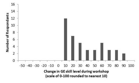
Figure 2.
Histogram of Participant Self-Reported GE Skill Level Change from Immediately Following the Workshop to the Time of Taking the Survey

GE Use Following Workshop
Most participants (81%) used Google Earth at least once since the workshop for various uses (Table 3). A majority of participants (62%) found GE to be a useful tool in the management of their land, while some found limited (31%) or no (7%) practical value (Table 4).
| Task | Count | % |
| Explore or learn more about my property | 28 | 80 |
| Measure area and distances | 22 | 63 |
| Explore other properties in the area | 22 | 63 |
| Show things about the property to family members | 20 | 57 |
| Map points or lines from a handheld GPS unit | 11 | 31 |
| Learn about the history of the property | 7 | 20 |
| Show things about the property to professionals such as foresters or loggers | 6 | 17 |
| Other (please describe) | 6 | 17 |
| Help me write a management plan | 4 | 11 |
| Help me update a management plan | 4 | 11 |
|
Note: Percentage is based on the number of participants who indicated they have used GE since the workshop. Respondents were allowed to select multiple tasks. |
||
| Answer | Count | % |
| Google Earth hasn't interested me and it doesn't help me take better care of my woods | 3 | 7 |
| Google Earth is a neat tool but it doesn't help me take better care of my woods | 13 | 31 |
| Google Earth is a useful tool that has helped me take better care of my woods | 26 | 62 |
|
Note: Not all survey respondents answered this question. |
||
Discussion/Implications
The GE workshops offered in Oregon resulted in positive learning outcomes in the short-term for all participants and in the long-term for some participants. Following completion of the workshop, participants used GE to plan and implement management activities and also to share information with family members and assistance providers.
While most workshop participants used GE following the workshop and continued to grow their skills, some participants stagnated in their learning or even lost skills in the time since the workshop. This loss of skill could likely be attributed to lack of time spent using GE. Ultimately, landowners won't use a tool that is not useful to them, and many participants reported that GE does not help them in their land management. Guevara, Swett, and Monroe (2013), in their evaluation of a series of GIS workshops for professionals, identified a similar lack of relevance among participants. Their solution was to implement an "active learning design" where participants worked together in small groups to solve a real world problem. Given the proven track record of peer-learning among landowners (Kueper, Sagor, Blinn, & Becker, 2014), this format could improve skill learning and utilization in this group. Lack of relevance might also be addressed by offering follow-up, advanced GE sessions specific to a single topic or to integrate GE skills into other courses. GE skills could, for example, be worked into a course on timber harvesting, road layout, rotational grazing, riparian restoration or any number of other topics.
Distance education could offer another opportunity to integrate GE with other topics. As online Extension education becomes more prevalent (Hightower, Murphrey, Coppernoll, Jahedkar, & Dooley, 2011), one can easily imagine how GE, with its ability to create and share geographic information, could be advantageously incorporated.
It was encouraging to see so many older landowners quickly gain skills with GE during this workshop. The success of this demographic in learning GE speaks to both the user-friendly interface of GE and also to the significant technology skills present in our older stakeholders. This gives credence to the growing body of evidence that Extension clientele, even its aging clientele, are not as technology-averse as was previously thought (Fishel & Ferrell, 2010; Seger, 2011).
The results of the workshop assessment indicate that with proper training, GE could expand GIS opportunities for landowners; however, to see continued use and skill building, care must be taken to make GE trainings relevant to the audience.
References
Butler, B. J. (2008). Family forest owners of the United States, 2006. Gen. Tech. Rep. NRS-27. U.S. Department of Agriculture, Forest Service, Northern Research Station. 72 p.
Fishel, F., & Ferrell, J. (2010). Does user age differ in perceptions of online learning for certified and licensed pesticide applicators? Journal of Extension [On-line], 48(5) Article 5RIB5. Available at: http://www.joe.org/joe/2010october/rb5.php
Google Inc. (2013). Google Earth (Version 7.1.2.2041) [Software]. Retrieved from: http://www.google.com/earth/
Guevara, C., Swett, R., & Monroe, M.C. (2013). Improving interactive workshops: A case study of GIS workshops. Journal of Extension [On-line], 51(2) Article 2TOT5. Available at: http://www.joe.org/joe/2013april/tt5.php
Hightower, T. E., Murphrey, P. T., Coppernoll, S. M., Jahedkar, J., Dooley, K. E. (2011). An examination of the strengths, weaknesses, opportunities, and threats associated with the adoption of Moodle™ by eXtension. Journal of Extension [On-line], 49(1) Article 1FEA1. Available at: http://www.joe.org/joe/2011december/rb3.php
Kueper, A. M., Sagor, E. S., Blinn, C. R., Becker, D. R. (2014). Extension forestry in the United States: Master Volunteer and other peer learning programs. Journal of Forestry, 112(1), 15-22
Rongxia, L., Bettinger, P., Danskin, S., & Hayashi, R. (2007). A historical perspective on the use of GIS and remote sensing in natural resource management, as viewed through papers published in North American forestry journals from 1976 to 2005. Cartographica, 42(2), 165-178.
Seger, J. (2011). The new digital [st]age: Barriers to the adoption and Aadaptation of new technologies to deliver Extension programming and How to Address Them. Journal of Extension [On-line], 49(1) Article 1FEA1. Available at: http://www.joe.org/joe/2011february/a1.php