August 2014
|
August 2014 // Volume 52 // Number 4 // Tools of the Trade // v52-4tt2


Google Earth: Low-Investment GIS for Extension Professionals
Abstract
Extension professionals need geospatial and remote sensing solutions that meet their varied needs; however, training time and funding for expensive software packages can be limited. Google Earth is a freely available, user-friendly GIS that can meet many of the day-to-day needs of Extension professionals by providing high-quality current and historical aerial photography, length and area measurement tools, GPS integration, and simple mapping capabilities. Third-party add-ons can increase the somewhat limited capabilities of Google Earth. Google Earth's general accessibility also lends itself to innovative, collaborative uses with clients, youth, and the general public.
Introduction
Geospatial tools, including geographic information systems (GIS), remote sensing (RS), and global positioning systems (GPS), have many uses for Extension professionals in the fields of agriculture, forestry, conservation, education, and applied research (Milla, Lorenzo, & Brown, 2005). These fields are served by a bewildering array of technologies, ranging from expensive with steep learning curves to free and very easy to learn. With the wide range of geospatial tools available, Extension professionals need solutions that meet their varied needs while keeping investments in training time and money to a minimum (Samson, 1995).
Google Earth (GE) (Google Inc., 2013) is a freely available, user-friendly GIS that can meet many of the day-to-day needs of Extension work. GE allows users to view archived aerial imagery and terrain models and also to create, save, and share geographic features. While the mapping and analysis tools of GE are less powerful than a full-featured commercial GIS such as ArcGIS, the intuitive interface and high-quality imagery available make it a good fit for natural resource and agriculture Extension programs.
Google Earth Features Relevant to Extension Professionals
High-Quality, Recent Aerial Photos
Google sources its images from a variety of commercial and government sources. In my coverage area (Oregon's South Coast), GE has very high resolution photographs from 2013. These are higher quality and more recent than the freely available USDA NAIP aerial photographs I usually work with. GE allows one to quickly view and print photos with no need to locate and download large aerial imagery coverages and load them into ArcGIS.
Historical Aerial Photos.
GE stores older images in its database, which allows users to look "back in time." Photographs in my region go back 20 years, showing a timeline of past management activities and changes in land use (Figure 1). Photographs from different seasons can be used to differentiate deciduous from evergreen forest types and to discern other seasonal differences in land cover.
Figure 1.
Imagery of Hybrid Poplar Plantation at Four Points in Time, (a) May, 1994 prior to poplar planting, (b) March, 2004 (note leaf-off condition of deciduous trees and higher river level), (c) August, 2007, (d) May, 2013 post-harvest with resprouting.
(a) 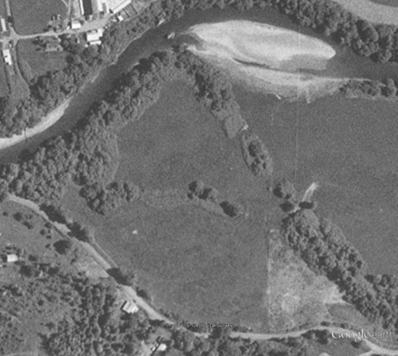
(b) 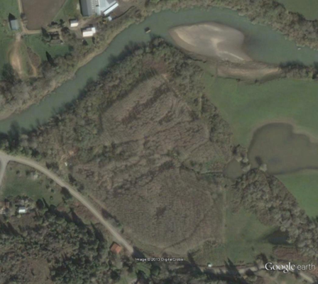
(c) 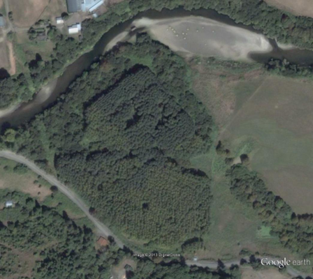
(d) 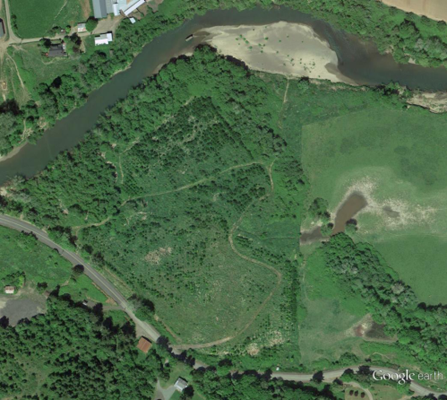
Measure Lengths and Areas
Lengths of roads, fence lines, irrigation layouts, etc., can be quickly estimated using GE's onboard tools. Acreage cannot be measured directly in the free version of GE, but there are some excellent third-party tools that make it possible to quickly measure area using GE. (See the discussion below of the upgraded "Pro" version and of available add-ons to the free version.)
Import GPS Lines and Points
Waypoints and paths can be directly imported into GE from a handheld GPS receiver. This feature is useful when marking points of interest during a site visit, mapping stands of trees or fields and documenting research plots and photopoints.
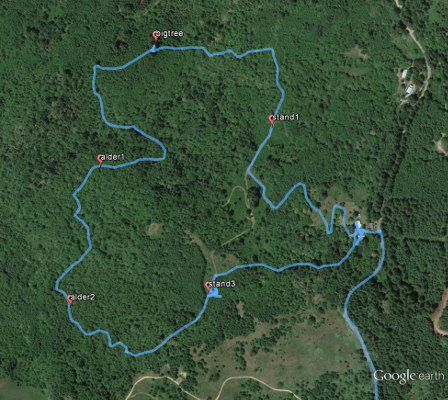
Figure 2.
GPS Track and Points from Tree Farm Site Visit. Data collected using Garmin GPSMap 62
Digitizing Features to Create Management Maps
Points, lines, and polygons are easily created and their appearances customized in GE to make management maps. Because these features are created and saved in GE's KML (keyhole markup language) format, maps can be shared digitally with anyone who has access to GE. The ability to label and create legends is limited in GE, so some amendments would need to be made using other software (such as Microsoft Office) to create a finished map.
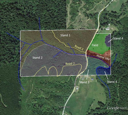
Figure 3.
Simple Management Map of a Mixed Forest/Agriculture Property. Polygons and roads were manually digitized in GE and streams were converted from an Oregon Department of Forestry shapefile into KML format using the "Layer to KML" geoprocessing tool in ArcGIS. Labels were added outside of GE using Microsoft Office.
Limitations of Google Earth
In exchange for an intuitive user interface and free access to high-quality aerial photography, users give up a great deal in terms of precision, database capabilities, and analytical power and when using GE instead of a full commercial GIS.
When digitizing features such as fields, stands of trees, roads, etc., to GE maps, only a simple point-and-click digitizing method is available instead of the more advanced snap, intersect, and merge features that are found in ArcGIS. This results in a level of precision that, while good enough for quick estimations and simple management maps, may not be acceptable for all uses.
GE is not a good solution for working with large sets of data because the amount of information that can be associated with a geographic feature is very limited (usually no more than a name and some descriptive text). In addition to not being able to catalog significant amounts of data, GE does not allow for complex analyses. For example, you can digitize roads and enter text describing whether they have a rock surface or native soil surface, but you cannot ask GE to calculate the total length of all rock roads or all native soil roads.
Add-On's Increase Google Earth's Capabilities
A "Pro" version of GE is available for an annual license fee that has a few more features, most notably an imbedded layer with tax lot boundaries and an area measurement function. However, the limitations of the free version of GE can be ameliorated somewhat by some useful add-ons and Web-based tools. University of New Hampshire Cooperative Extension's KML Tool Project (http://extension.unh.edu/kmlTools/) allows users to manipulate KML files to calculate acreage, create buffers, and lay out systematic or random survey points. If one needs a property boundary layer, datasets can be purchased with tax lot and owner information along with Public Land Survey System layers for most areas of the country. (http://www.huntinggpsmaps.com/computer-hunt-maps). This dataset is very useful for day-to-day Extension work, but be aware that ownership information can change between updates.
Conclusion
GE can be quickly adopted and put to work by Extension programs with little investment of time or money. There are many more uses for GE that go beyond the scope of this article; once one is comfortable with GE, he or she may want to look into other uses including:
- Virtual tours complete with videos, photographs, and narration (http://www.google.com/earth/outreach/)
- Using GE and KML files on your smartphone or tablet while working in the field (http://www.google.com/mobile/earth/)
- GE as a tool for youth geospatial education (Johnson, McGee, Campbell, & Hays, 2013)
Perhaps GE's most exciting and promising aspect lies in its accessibility, allowing it to be used by the Extension professional and layperson (Extension client) alike (Hamilton et al., 2009) . Having a shared tool opens up many new opportunities for outreach, education, and cooperation.
References
Google Inc. (2013). Google Earth (Version 7.1.2.2041) [Software]. Retrieved from: http://www.google.com/earth/download/
Hamilton, N. J., Mijatovic, B., Mueller, T. G., Lee, B. D., Kew, B. W., Cetin, H., & Karathanasis, A. D. (2009) Google Earth dissemination of soil survey derived interpretations for land use planning. Journal of Extension [Online], 47(5) Article 5FEA3. Available at: http://www.joe.org/joe/2009october/a3.php
Johnson, L., McGee, J., Campbell, J., & Hays, A. (2013). The Virginia geocoin adventure: An experiential geospatial learning activity. Journal of Extension [Online], 51(4) Article 4IAW4. Available at: http://www.joe.org/joe/2013august/iw4.php
Milla, K. A., Lorenzo, A., & Brown, C. (2005). GIS, GPS, and remote sensing technologies in Extension Services: Where to start, what to know. Journal of Extension [Online], 43(3) Article 3FEA6. Available at: http://www.joe.org/joe/2005june/a6.php
Samson, S. A. (1995). Determining need for a geographic Information system (GIS). Journal of Extension [Online], 33(5) Article 5TOT2. Available at: http://www.joe.org/joe/1995october/tt2.php