October 2013
|
October 2013 // Volume 51 // Number 5 // Research In Brief // v51-5rb5


Comprehensive Land Use Planning in Exurban Communities: A Case Study from Ohio
Abstract
Comprehensive land use planning at the county level has been a focus of a good deal of public attention in the U.S. in the post-World War II era. Because Extension is typically very active at the county level and provides substantial expertise on land use at the university level, it has long played a significant role in the planning process. This article reports the findings of a survey among residents of an exurban community on land use designed to obtain public opinion prior to the update of a comprehensive plan, contributing a sense of public inclusion to the process.
Introduction
Extension has had a long history in helping communities with comprehensive land use planning. This can be seen by perusing the extensive amount of literature that has been published on the topic in JOE over the years. An early example is a very sobering article by Vaughn (1971) that highlighted limitations of land use planning in combating chronic problems like poverty. More recently, Arnold (2000) urged that Extension make land use a central theme of education, research, and outreach in order to maintain relevance.
A great deal of community planning has always occurred at the county level (McLeod, Coupal, Seidl, Inman, & Taylor, 2003). This tends to be a good fit for Extension, which typically has offices and professionals (agents and or educators, along with Extension associates and program assistants) at the county level.
Moreover, countywide comprehensive plans have become very common across the U.S. in recent decades. Extension involvement with the comprehensive land use planning process has been described by Haines (2002) and more recently by Lee and Kew (2008).
Elected officials who authorize the development of a land use plan may wish to foster a sense of public inclusion in the planning process. They can better justify or explain local land use policies if those policies are based on a comprehensive plan (Moss & Grunkemeyer, 2010). Obtaining public opinion via surveys prior to the initiation of the planning process can provide an additional layer of accountability for these officials (Goldberg, 2005; Inman, McLeod, & Coupal, 2002).
In addition to provision of local resources for land use planning, Extension also contributes considerable expertise in obtaining measures of public opinion on a wide variety of issues, including land use (Blaine, 2005). This is especially true when Extension resources at the county level are combined with those at the regional and state level, where the research resources of the land-grant university can be brought to bear to conduct rigorous studies of public opinion (Arnold, 2000; McLeod et al., 2003). Local officials in many communities are aware of this.
Land use pressures are often greatest in communities located just beyond the rural-urban fringe—called "exurban communities." The flight of middle class households to suburban areas during the post World War II era has been well documented, and is a topic that is somewhat familiar to most Americans. But trends in residential and commercial development well beyond the "suburbs" intensified in the 1990s and 2000s, consuming large amounts of farmland and open space in exurban communities across the U.S. and causing concerns as to whether many of these communities will be able to maintain a viable agricultural industry as well as a sense of rural character in the future.
How can a traditional rural and agricultural community maintain its identity if it happens to be located adjacent to a large, expanding urban center? Examining the communities that have been successful in achieving these objectives may provide a model for others who are currently facing this challenge, or may face it in the future.
Study Area, Survey Design, and Method
Madison County Ohio (population 43,435; Ohio County Profiles: Madison County, 2011) is an exurban community located in central Ohio, adjacent to Franklin County, which is home to the state capital and largest city in Ohio, Columbus. Like many urban areas, Columbus has produced a great deal of population growth and concomitant expansive urban, suburban, and exurban development throughout the county in which it is located as well as a number of adjacent counties. Yet Madison County has been able to maintain low levels of population growth despite the expansion of Columbus.
Maintaining a rural atmosphere as well as a vibrant agricultural industry has been a goal of many residents. An important environmental asset in the county is Little Darby Creek, the primary tributary of the Big Darby, which is one of the most biologically diverse aquatic ecosystems in the Midwestern U.S. (The Nature Conservancy, 2011).
In the spring of 2010, the Madison County Commissioners began the 5-year update of the county's Comprehensive Land Use Plan. The commissioners established a task force consisting of representatives of townships, villages, the soil and water conservation district (SWCD), Farm Bureau, business, the news media, the Ohio Department of Natural Resources (ODNR), and Ohio State University (OSU) Extension.
The task force asked county OSU Extension to undertake a public opinion survey on land use. The county Extension office brought in regional and state Extension staff to work with the task force to develop the survey. At a public meeting held in March 2010, the task force reviewed a survey instrument that Extension had developed 5 years before and implemented prior to the adoption of the previous land use plan. Each task force member examined the questions in the survey, and everyone was allowed to give feedback as to whether survey questions achieved construct validity and reliability. OSU Extension regional and state staff provided technical expertise in survey question development and facilitated the discussion. Once the task force agreed on the questions, they constructed a timeline for survey implementation, including follow-up, input and analysis of data, and a date for the presentation of the final report to the task force and the public.
Following procedures recommended by Dillman (1978), representatives of the task force mailed post cards to a sample of 800 Madison County residents whose names and addresses were randomly selected from a list provided by the County Auditor. The auditor's office itself used an on-line random number generator to select a list of 800 respondents from the master list of 18,507 it had on file. The post cards indicated that a survey on land use would be arriving in the mail within 2 weeks. The surveys were sent out in late May to the 800 residents, along with a cover letter signed by the one of the commissioners and the state Extension representative. The letter explained the rationale behind the research initiative, emphasizing the importance of public input to the planning process. The letter requested that recipients return the completed survey within 10 days. A total of 205 residents responded with completed surveys by the requested date. Follow-up letters were then sent to non-respondents, who were asked to return completed surveys by a date in late June. A total of 54 complied, bringing the total number of surveys to 259, for a response rate of 32%.
County Extension recruited volunteers from the public to input the data from the survey into SPSS (Statistical Package for the Social Sciences). State, regional, and county Extension personnel conducted a training session in July to acquaint the volunteers with SPSS data input, which was completed by August. The report was finalized and presented at a public meeting in September.
Results and Discussion
Initial data analysis involved comparing early respondents (those who returned the survey by the initial deadline) to late respondents (those who responded to the second mailing). Statistical tests (Chi-Square) showed no significant differences between early and late respondents (p > .05), indicating that non-response bias is not likely to be a problem for the study reported here (Lindner & Wingenbach, 2002; Miller & Smith, 1983; Wiseman, 2003).
In the first portion of the survey, respondents were asked about their awareness of county plans and their views on frequency of plans. The results are presented in Table 1 and Figure 1.
| Plan Type | Yes | No | n |
| Comprehensive Land Use Plan | 46 | 54 | 241 |
| 208 Plan for Waste Water (planning phase) | 25 | 75 | 235 |
| County Zoning Plan | 61 | 39 | 238 |
| Farmland Preservation Plan | 56 | 44 | 241 |
The results show that about half of respondents (46%) were aware of the comprehensive land use plan. The highest level of awareness (61%) was associated with the county zoning plan. This should not be surprising, since zoning is so controversial, and therefore people in the general public tend to remain somewhat well informed about it. There was relatively little awareness (25%) of the 208 plan for waste water. A slight majority (56%) of respondents were aware of the farmland preservation plan.
Figure 1.
Opinions on Timing of Reviews of Plans (n = 196)
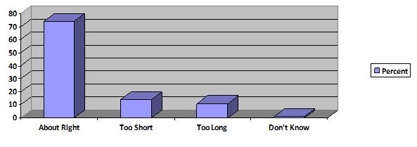
Most respondents (74%) believed that the 5-year interval between plans is about right, with small percentages roughly equally believing that they are either too far apart or too frequent.
Next, respondents were presented with a series of choices designed to obtain their views on current rates of development and the amount of population growth they would like to see in the community.
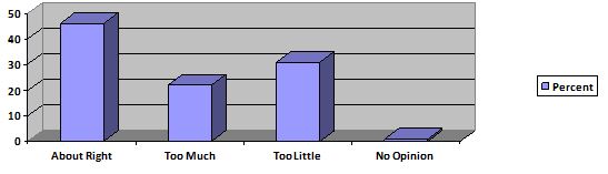
Figure 2 shows the perceptions of the overall development rate. Roughly half of respondents (46%) believed that the rate of development is "about right," while fewer than 2% had no opinion.
Figure 2.
Views on Current Rate of Development in the Community (n = 199)
Respondents were asked to give their views on desired population growth they would like to see in the county by 2030. The results are presented in Figure 3.
Figure 3.
Desired Population Growth in the County to 2030 (n = 245)
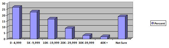
A plurality (27%) would like to see growth remain below 5,000 over the period to 2030, which would maintain a total population below 50,000. But a considerable percentage (19%) remained unsure on the issue of population growth.
Next, respondents were asked to provide rankings on the kinds of development they prefer to see. Development types were placed in the following categories: industrial, commercial, residential, recreational, agricultural, "other," and no development. Each respondent was asked to check two of the development types most preferred. The results are presented in Figure 4.
Figure 4.
Types of Development Most Preferred (Percentages sum to 200 due to multiple selections—two per respondent; n = 247)
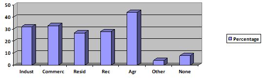
The results in Figure 4 indicate that there is a broad range of support for a blend of development in the community. The highest level of support goes to agricultural development, reinforcing the idea that members of the community want to maintain the agricultural viability in the economy. But industrial and commercial development also received considerable support, each appearing on roughly one third of all respondent rankings. Taken together, these results suggest that pursuing value-added agriculture (e.g., food processing) would be an acceptable economic strategy for the community. On the other hand, only 8% checked "no development," implying that anti-development attitudes are not widespread among respondents.
Respondents were presented with a series of statements about the community and asked to respond on a five point Likert-type scale, ranging from strongly agree to strongly disagree. The results are presented in Table 2.
| Strongly Disagree | Disagree | Neutral | Agree | Strongly Agree | n | |
| Madison County is developing in the right direction. | 5 | 12 | 41 | 38 | 3 | 235 |
| I am optimistic about the future of Madison County. | 2 | 8 | 28 | 55 | 7 | 236 |
| Madison County should control rural residential development. | 5 | 13 | 12 | 45 | 24 | 243 |
| Zoning to protect farmland should be a priority in Madison County. | 4 | 6 | 16 | 39 | 35 | 242 |
| Madison County needs more public places for recreation. | 9 | 15 | 33 | 32 | 11 | 239 |
| Madison County should spend more money on recreational facilities. | 13 | 21 | 31 | 27 | 8 | 238 |
| Madison County needs to have a balance of agriculture, business, and residential development. | 2 | 6 | 16 | 54 | 22 | 241 |
| We should attract more business to Madison County. | 3 | 6 | 18 | 46 | 27 | 242 |
| We need more housing in Madison County. | 9 | 22 | 40 | 23 | 6 | 238 |
| Madison County is a good place to raise children. | 1 | 1 | 14 | 54 | 30 | 244 |
| Madison County should allow development to take its own course. | 22 | 37 | 21 | 15 | 5 | 241 |
| Zoning of all development is important in Madison County. | 6 | 7 | 14 | 50 | 23 | 238 |
The mixed results on the first statement in Table 2 indicate that there is considerable uncertainty about the overall direction of the community, but respondents remain optimistic about its future, as reflected in the results on the second statement. A key indicator of the degree to which respondents have a positive view of the community is the result that shows that 84% either agree or strongly agree that Madison County is a good place for raising children.
The results on attracting businesses in the community provide support for the inference obtained from Figure 4 that respondents are not anti-development, as do the results on having a blend of different types of development. But large majorities believe that development should not be allowed "to take its own course" and that zoning of all development is important for the community. In other words, while respondents favor a number of types of development, they do have strong preferences for how development should proceed, and they support government action via zoning to ensure that it do so in a way that preserves the agricultural economy and the rural character of the community.
Next, respondents were asked about provisions in the comprehensive and zoning plans. The results are presented in Table 3.
| Yes | No | Don't Know | n | |
| The current Madison County Comprehensive Land Use Plan calls for new residential development to be primarily located inside the current city and village corporate limits. Do you agree with that part of the plan? | 81 | 17 | 2 | 198 |
| The Zoning Plan for Madison County has a provision that no buildings can be erected within 120 feet of Little Darby Creek. Should that restriction be extended to all streams in the county? | 64 | 36 | 0 | 183 |
| Should Madison County continue with the Farmland Preservation Plan? | 88 | 10 | 2 | 177 |
These results show that there is very strong support among respondents for new residential development to occur within corporate limits of cities and villages. Nearly 2/3rds of respondents believe that the zoning restriction on building within 120 feet of Little Darby Creek should be extended to all streams within the county.
A total of 88% support the county continuing with the farmland preservation plan. Note that this number is considerably higher than the 56% who were aware that the plan exists (Table 1). This kind of result reveals that the process of surveying respondents in a community is not static. It is highly likely in this case that a segment of respondents, now made aware by participating in the survey that the farmland preservation plan exists, support it.
Conclusions and Implications
Exurban communities throughout the U.S. have been facing and continue to face the challenge of maintaining their identity in the face of expansion of urban areas. Extension has a role to play in this effort. The study reported here shows how Extension mobilized resources at the county, regional, and state level in response to the requests of elected officials in an exurban county to measure public opinion on land use. Extension can provide a unique role in educating and facilitating community task forces and community leadership in the development of effective instruments to gage community attitudes and desires toward planning and future land use.
The results reveal that while respondents are not anti-development, they do have strong preferences in favor of managing and directing future development in order to maintain the rural identity and the viability of the agricultural industry in their community. They generally favor the 5-year period for review of development plans and strongly support continued efforts to protect farmland and sensitive areas like wetlands and streams. Moreover, they support specific policies for achieving these goals, including zoning and restricting areas where development can occur—particularly relating to prime farmland and impacts on streams. There is also strong support for attracting more business to the county, and value added agricultural development would appear to be a priority among respondents.
The results also reveal a dynamic aspect of community-based surveys. Initially, only a slight majority of respondents were aware of the county farmland preservation plan. By the end of the survey, however, many of those who had not known about the existence of the plan before now expressed support for continuing it.
By participating in the survey, Madison County residents helped to guide the direction of the 5-year update of the county's comprehensive plan. Public opinion confirmed the desirability of existing land use policies and identified measures to protect agricultural viability and the rural character of the community. The land use survey and comprehensive plan update, completed in the fall of 2010, led to the subsequent update of the county's Farmland Preservation Plan in the fall of 2011. The comprehensive plan set the stage for this further examination and development of policies supportive of agriculture in Madison County.
The study reported here can serve as a model for those interested in obtaining measures of public opinion on a variety of issues—including land use. Madison County has been successful in maintaining a rural and agricultural community even though it is adjacent to a large and expanding urban center. The kinds of opinions reported here among its residents have likely shaped the land use policies that have allowed the community to maintain its rural atmosphere and agricultural industry in recent decades. Members of exurban communities that face pressure from expanding urban centers should consider using public opinion surveys as a means to guide policies that promote planning and growth while also protecting farmland and natural areas.
References
Arnold, C. L. (2000). Land use is the issue, but is land grant the answer? Journal of Extension [On-line], 38(6) Article 6COM1. Available at: http://www.joe.org/joe/2000december/comm1.php
Blaine, T. W. (2005). Applied Extension research in an era of devolution. Journal of Extension [On-line], 43(2) Article 2COM1. Available at: http://www.joe.org/joe/2005april/comm1.php
Daniels, T.L. (1999). When city and county collide: Managing growth in the metropolitan fringe. Washington, DC: Island Press.
Dillman, D. A. (1978). Mail and telephone surveys: The total design method. New York: John Wiley and Sons.
Goldberg, D. (2005). Choosing our community's future. Washington, D.C.: Smart Growth America.
Haines, A. L. (2002). Blended learning: Land use education in Wisconsin and lessons learned. Journal of Extension [On-line}, 40(5) Article 5IAW2. Available at: http://www.joe.org/joe/2002october/iw2.php
Inman, K., McLeod, D. M., & Coupal, R. H. (2002). Uinta County: A case study in Wyoming land use planning. Journal of the Community Development Society, 33(2): 91-111.
Lee, B. D., & Kew, B. W. (2008). A workshop about land-use decision-making in the context of community/societal values. Journal of Extension [On-line], 46(5) Article 5IAW1. Available at: http://www.joe.org/joe/2008october/iw1.php
Lindner, J. R., & Wingenbach, G. J. (2002). Communicating the handling of nonresponse error in Journal of Extension research in brief articles. Journal of Extension [On-line], 40(6) Article 6RIB1. Available at: http://www.joe.org/joe/2002december/rb1.php
Moss, M. L., & Grunkemeyer, W. T., (2010). Building shared visions for sustainable communities. Journal of the Community Development Society, 41(2): 240-254.
McLeod, D., Coupal, R., Seidl, R.A., Inman, K., & Taylor, D. (2003). Opportunities and challenges for land use planning in the intermountain west. Journal of Extension [On-line], 41(5) Article 5FEA5. Available at: http://www.joe.org/joe/2003october/a5.php
Miller, L. E., & Smith, K. L. (1983). Handling non-response issues. Journal of Extension [On-line], 21(5): 45-50. Available at: http://www.joe.org/joe/1983september/index.php
The Nature Conservancy (2011). Ohio Darby Creek watershed. [On-line]. Retrieved from: http://www.nature.org/ourinitiatives/regions/northamerica/
unitedstates/ohio/placesweprotect/darby-creek-watershed.xml
Ohio County Profiles: Madison County (2011). Office of Policy, Research and Strategic Planning, Ohio Department of Development. Retrieved from: http://www.development.ohio.gov/research/files/s0/Madison.pdf
Vaughn, G. F. (1971). Extension's part in better communities: A case study. Journal of Extension [On-Line], 9(4). Available at: http://www.joe.org/joe/1971winter/1971-4-a4.pdf