August 2013
|
August 2013 // Volume 51 // Number 4 // Research In Brief // v51-4rb3


A Comparison of Recreational- and Intermediate Survey-Grade GPS Units for Importing Data into GIS Software Packages
Abstract
Global positioning systems (GPS) and Geographic Information Systems (GIS) have become common tools for Extension professionals. These systems vary in terms of accuracy and cost. GPS ranges from recreational-quality to survey-quality, with intermediate levels in between. As the user moves from recreational-quality to survey-quality, both accuracy and cost increase. We compare a recreational GPS unit (Garmin) and importing data into Google Earth software and an intermediate survey-grade GPS unit (Trimble Juno) and importing data into ArcMap GIS software. These represent two of the most common GIS choices available to natural resource professionals. Cost effectiveness will depend on accuracy requirements.
Introduction
A global or geographic information system (GIS) is a software product used for mapping or geographical data analysis purposes. It is defined as a computer-based system to aid in the collection, maintenance, storage, analysis, output, and distribution of spatial data and information (Bolstad, 2012). GIS is a spatial tool that can enhance field and office productivity of agricultural and natural resource professionals and Extension agents in terms of on-the ground applications (Milla, Lorenzo, & Brown, 2005).
A Global Positioning System (GPS), a navigational tool, is also used to collect spatial data that may then be imported into GIS software to create maps. It calculates position on earth using a constellation of 24 satellites developed by the U.S. Department of Defense (Brase, 2006).
Once users establish the need for GIS (Samson, 1995), specific tools can be matched to each task (Merry, Bettinger, & Hubbard, 2008a, 2008b). These tools are used for more than to just generate maps; Extension-related uses include watershed management (Meeker, Tate, Czapar, & Vaughan, 2005), disaster planning (Brown, Crum, & Foote, 2003), landscape use (Rozum, Wilson, & Arnold, 2005), agricultural production practices (Flynn & Arnold, 2010), and identification of agricultural and forestry educational needs (Bridges, 2008).
Geospatial tools originally used to be specialized, complex, and costly. Today they are less technical and less costly, and their use has become the norm for spatial aspects of Extension activities (McGee & Kirwan, 2010). There is a broad spectrum of GIS software packages that serve multiple purposes and technical levels at corresponding costs (Veith, Wolfe, & Heatwole, 2003). The major source for GIS software is Esri (Esri, 2012), a major GIS software developing company that developed the well-known GIS software package ArcGIS.
Methods
Along with the different GIS systems there are also different brands of GPS receivers that collect the raw data that is inputted into the GIS software systems. There are small recreational GPS units and survey-grade GPS units, and many intermediate-level units in between. Both cost and accuracy increase as the user moves from recreational-grade to survey-grade units. However, the quality of cheaper recreation units has been increasing as the technology continues to develop. This makes the choice of GIS/GPS systems difficult for field applications, because the cost-effective choice of units is not always easy to determine (Merry, Bettinger, & Hubbard, 2008a; Merry, Bettinger, & Hubbard, 2008b).
Our objective was to assist the average Extension professional or landowner to better understand the costs and benefits of basic mapping with two different software package options. We compared two of the most common choices field professionals have in terms of GPS and GIS systems used to perform standard field mapping and spatial operations. Our comparison is of a recreational GPS unit (Garmin) importing data into Google Earth software and an intermediate survey-grade GPS unit (Trimble Juno) importing data into ArcMap GIS software. Few organizations can afford to hire GIS personnel and use survey-grade GIS and GPS equipment. Our two options are realistic alternatives that provide reasonable tradeoffs between cost and accuracy. The Extension professional can make his or her own decision on cost-effectiveness.
The recreational-grade GPS unit was the Garmin 60CSX, which costs $400 (Garmin, 2012). Other free software was needed with this option: Basecamp software to import the GPS data into the GIS package (Basecamp, 2012) and Google Earth to generate the maps by overlaying GPS data on top of aerial photography (Google Earth, 2012). The only additional software needed with this unit was the local topographic map set that was uploaded onto the GPS unit at a cost of $130. The total cost of this option was $530.
The intermediate survey-grade GPS unit was the Trimble Juno, which cost $675 (Trimble, 2012a). Along with the receiver itself, the GPS software packages needed to collect and manipulate the data were TerraSync, which costs $1,165 (Trimble, 2012b), and GPS Pathfinder Office, which costs $1,795 (Trimble, 2012c). This option required ArcMap, which costs $1,500 for a single use license (Esri, 2012). The total cost of this option was $5,135.
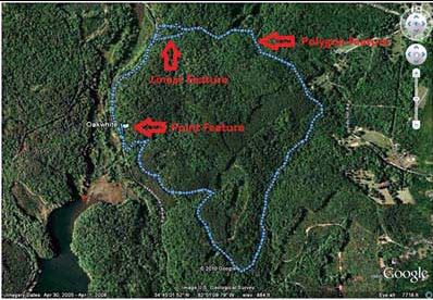
The Clemson University Experimental Forest was used as the study area. The 17,500-acre forest is located immediately north and south of Clemson University near Clemson, South Carolina. The GPS data collection was conducted near Wildcat Creek Recreational Area, north of Lake Issaqueena (Figure 1).
Figure 2 shows the process flow charts for collecting and importing the GPS data using the Trimble Juno and Garmin. These flowcharts present the step-by-step methodology and allow for comparisons. A polygon feature (compartment boundary line using the Juno unit as the reference line), linear feature (access road going into the Wildcat Springs area), and point feature (a specific white oak (Quercus alba) tree that was located 66 feet inside the polygon) were collected for the comparison. Having all three features inside or near the compartment boundary allowed for a central location area of interest.
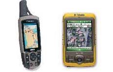
Both GPS receivers were used simultaneously, to ensure that they were collecting at the same spot and time, allowing for direct comparisons of the two data sets. Operating systems differed, so knowledge of both was crucial for field use to obtain raw GPS data and for making proper recommendations. Figure 3 is an image of the Garmin 60CSX and the Trimble Juno SB GPS units.
Once the data collection was completed, the raw GPS data were transferred into the two different GIS software packages. The Trimble Juno GPS data were transferred first by importing them into GPS Pathfinder Office, differentially correcting all of the raw GPS files and exporting each of them as a shapefile. Differential correction is a technique to reduce small systemic errors caused by factors such as tree cover and atmospheric conditions (Morgan-Owen & Johnston, 1995). A shapefile allows for transfer of spatial data (points, polygons, etc.) that represent things like roads, lakes, and rivers. The shapefile was then brought into ArcMap GIS software.
Figure 1.
Map Area of Compartment 312 Clemson University Experimental Forest
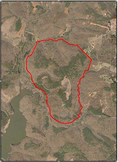
Figure 2.
Process Flow Charts for Collecting and Importing Juno and Garmin Data
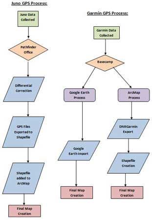
Figure 3.
The Garmin 60CSX Recreational- (left) and Juno Intermediate Survey- Grade (right) GPS Units
The Garmin 60CSX (recreational) GPS was connected into the computer, and all the files were transferred into a folder to save for backup purposes through the Basecamp software package to allow for transfer of files from the recreational GPS unit to the computer. Then the Garmin GPS data were transferred into Google Earth by plugging the unit into the computer, automatically causing the Garmin GPS data files to overlay on top of the Google Earth aerial photography.
The two different types of GPS data were evaluated by comparing the two maps to check for accuracy. This required the Garmin GPS data to be imported as shapefiles and brought into the ArcMap GIS software using the free software tool GarminDNR (Minnesota DNR, 2012). Once the tool was downloaded, it was automatically brought into ArcMap for use.
Results and Discussion
Once the raw GPS data were imported into ArcMap, a data comparison revealed spatial differences between the Garmin 60CSX and the Trimble Juno GPS, and a measuring tool was used to find the lengths of the offsets for each. Table 1 below shows the average spatial deviation in distance (feet). Figure 4 is a visual depiction of this same spatial difference. The Garmin GPS data appear to be more accurate than the Trimble Juno data because the features seem to line up more appropriately on the resulting map. This results from both GPS units being as close as possible during data collection to provide consistency. A close evaluation of Figure 4 shows that the Trimble Juno GPS features are farther spatially from the true boundary, while the Garmin GPS features are constant with that boundary.
| Distances (feet) | |
| Polygon | 44.3 |
| Linear | 28.7 |
| Point | 46.7 |
Figure 4.
Garmin and Juno GPS Data Overall Comparison Map
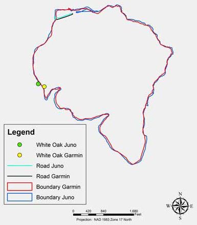
To get a better idea of how these data compare, focus was directed on the different features collected. These polygon features are very consistent with each other visually. On average they are spatially different from each other by 44.3 feet (determined by using the measure tool in ArcMap to measure differences at 20 random points around the polygon).
Figure 5 is an image that shows a comparison of the difference in a linear feature (a road) and in a polygon feature or point (a tree). Both linear features were collected from the start of each polygon boundary and ended at Wildcat Creek recreational picnic shelter. The Garmin linear feature is shown in black and the Juno linear feature is shown in teal. The average distance that is shown between the roads is 28.7 feet which was found using the ArcMap measuring tool. The nearby boundaries are also shown.
Figure 5.
Comparison of a Linear Feature (Road) and a Point Feature (Tree)
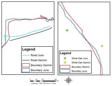
The point feature (a white oak tree) focuses on accuracy. The Garmin point feature (shown as a yellow dot) is inside the collected GPS polygon boundaries, while the Juno point feature (shown as a green dot) is outside the collected GPS polygon boundaries. The points were collected very close to the GPS polygon boundaries to determine distance from the boundary. The point was selected as the nearest tree that was measured 66 feet into the forest perpendicular from the polygon boundary line. When using the ArcMap measuring tool, the distance to the Garmin point feature from the Garmin polygon feature, which came out to be 65.4 feet within the boundary. The same measurement using the Juno point feature and the Juno polygon feature placed the point 44.2 feet outside of the polygon area.
Following the ArcMap analysis, the Garmin GPS data were downloaded into Google Earth. ArcMap software required the long process of adding layers, while Google Earth automatically takes in the GPS data and overlays it onto the aerial photography. Figure 6 shows the Google Earth result. GPS features are individually identified to illustrate how they would look. The distance from the polygon GPS feature to the point GPS feature was measured to see if it was close to 66 feet, and Google Earth showed the distance to be 53.3 feet.
Figure 6.
Garmin and Juno GPS Comparison Map
Conclusion
If cost is a driving factor for mapping purposes, the best option is the recreational package, with a cost of $530.00, for a simple but fairly accurate mapping system. The recommended "survey" package would include the Trimble Juno GPS unit, TerraSync, GPS Pathfinder Office, and ArcMap. This package has more power and options, but an estimated cost of $5135.00. The advantages of using the "survey" package are the option to have more tools for mapping, the ability to obtain and better manipulate clearer aerial photography, and often a representative to help with questions. The disadvantages are a steep learning curve, greater cost for the field forester or landowner, and the required use of multiple software packages to create a map.
The recommended recreational package includes a choice of a cheaper GPS unit, topographic maps, Basecamp, and Google Earth. One recommendation would be to use the Garmin 60CSX GPS unit and the Google Earth software package. The advantages of using the recreational package are affordability, accuracy similar to the Trimble-based unit, and a simple learning curve. The disadvantages of using the recreational package are the limits on customizing the map layout (i.e., title, north arrow, legend, and scale bar) and reduced resolution in some cases. (Google Earth aerial photography may not be as clear as the ArcMap aerial photographs.) The use of extra software like Basecamp to import data is an added step in the mapping process. However, with 10 times less the package cost, the recreational GPS units appear to be nearly as accurate as the Trimble survey-grade units.
References
Basecamp. (2012). Garmin Basecamp homepage. Retrieved from: http://www.garmin.com/us/products/onthetrail/basecamp
Bolstad, P. (2012). GIS Fundamentals A first text on geographic information systems (4th ed.). White Bear Lake, MN: Eider Press.
Brase, T. A. (2006). Precision agriculture. Clifton Park, NY: Thompson Delmar Learning.
Bridges, C. A. (2009). Identifying agricultural and forestry educational needs using spatial analysis techniques. Journal of Extension [On-line], 46(3) Article 3TOT6. Available at: http://www.joe.org/joe/2008june/tt6.php
Brown, S. C., Crum, S., & Foote, V. S. (2003). GIS and GPS emergency response lessons learned from the Space Shuttle Columbia disaster. Journal of Extension [On-line], 41(4) Article 4IAW1. Available at: http://www.joe.org/joe/2003august/iw1.php
Esri. (2012). Esri homepage. Retrieved from: http://www.esri.com
Flynn, A., & Arnold, S. (2010). Advancing technology: GPS and GIS outreach training for agricultural producers. Journal of Extension [On-line], 48(3) Article 3IAW5. Available at: http://www.joe.org/joe/2010june/iw5.php
Garmin. (2012). Garmin homepage. Retrieved from: http://www.garmin.com/us
Google Earth. (2012). Google Earth Homepage. Retrieved from: http://www.google.com/earth/index.html
McGee, J., & Kirwan, J. (2010). The sky's the limit: Integrating geospatial tool with pre-college youth education. Journal of Extension [On-line], 48(1) Article 1TOT5. Available at: http://www.joe.org/joe/2010february/tt5.php.
Meeker, S., Tate, J. L., Czapar, G. F., & Vaughan, T. (2005). A Web-based resource for watershed management in Illinois. Journal of Extension [On-line], 43(3) Article 3TOT6. Available at: http://www.joe.org/joe/2005june/tt6.php
Merry, K. L., Bettinger, P., & Hubbard, W. G. (2008a). Back to the future part I: Surveying geospatial needs of Georgia land use planners. Journal of Extension [On-line], 46(3) Article 3RIB6. Available at: http://www.joe.org/joe/2008june/rb6.php
Merry, K. L., Bettinger, P., & Hubbard, W. G. (2008b). Back to the future part I: Surveying geospatial needs of Georgia agriculture and natural resources Extension professionals. Journal of Extension [On-line], 46(4) Article 4RIB1. Available at: http://www.joe.org/joe/2008august/rb1.php
Milla, K. A., Lorenzo, A., & Brown, C. (2005). GIS, GPS, and remote sensing technologies in Extension Services: Where to start, what to know. Journal of Extension [On-line], 43(3) Article 3FEA6. Available at: http://www.joe.org/joe/2005june/a6.php
Minnesota DNR. (2012). Minnesota Department of Natural Resources DNR Garmin application. Retrieved from: http://www.dnr.state.mn.us/mis/gis/tools/arcview/extensions/DNRGarmin/DNRGarmin.html
Morgan-Owen, G. J., & Johnston, G. T. (1995). Differential GPS positioning. Electronics & Communication Engineering, 7, 11-21.
Rozum, J. S., Wilson, E., & Arnold C. (2005). Strengthening integration of land use research and outreach through innovative web technology. Journal of Extension [On-line], 43(5) Article 5IAW1. Available at: http://www.joe.org/joe/2005october/iw1.php
Samson, S. A. (1995). Determining the need for a geotropic information system (GIS). Journal of Extension [On-line], 33(5) Article 5TOT2. Available at: http://www.joe.org/joe/1995october/tt2.php
Trimble. (2012a). Trimble Juno series handhelds. Retrieved from: http://www.trimble.com/mappingGIS/juno3.aspx?dtID=applications&
Trimble. (2012b). Trimble TerraSync series. Retrieved from: http://www.trimble.com/mappingGIS/TerraSync.aspx?dtID=applications&.
Trimble. (2012c). Trimble Pathfinder Office software. Retrieved from: http://www.trimble.com/mappingGIS/PathfinderOffice.aspx?dtID=applications&.
Veith, T. L., Wolfe, M. L., & Heatwole, C. D. (2003). Optimization procedure for cost effective BMP placement at a watershed scale. Journal of the American Water Resources Association, 46, 1331-1343.