August 2013
|
August 2013 // Volume 51 // Number 4 // Ideas at Work // v51-4iw4


The Virginia Geocoin Adventure: An Experiential Geospatial Learning Activity
Abstract
Geospatial technologies have become increasingly prevalent across our society. Educators at all levels have expressed a need for additional resources that can be easily adopted to support geospatial literacy and state standards of learning, while enhancing the overall learning experience. The Virginia Geocoin Adventure supports the needs of 4-H groups and other educators, by providing a low-cost and user-friendly entry point to expose students to geospatial tools, such as GPS receivers, geographic viewers, and basic remote sensing techniques.
Introduction
The influence of geospatial technologies can be found in many fields, including natural resource management, agriculture, business, emergency services, and public health. Geospatial technologies form core components of an expanding variety of industries (Tomlinson, 2003). Geospatial technologies include:
- Remote sensing: information collected from a distance, usually by satellite imagery or aerial photography;
- GIS (Geographic Information Systems): a powerful tool that combines spatial information with attribute data and can be used for display, analysis, and storage;
- GPS (Global Positioning System): a satellite and receiver based system used for navigation and measurement (Milla, Lorenzo, & Brown, 2005; Shellito, 2012).
In 2003, the U.S. Department of Labor identified the geospatial field as one of three most important emerging career fields (Gewin, 2004). A recent study conducted by DaraTech, Inc. found that the industry grew 10.3% in 2010 and was anticipated to grow 8.3% in 2011 (Foundyller, 2009).
As the geospatial industry grows, the demand for geospatially literate professionals grows, and the need for education of pre-college students in geospatial technologies also increases to fuel this "pipeline" (McGee & Kirwan, 2010). Pre-college students who will not ultimately pursue geospatial careers will also need to master a basic understanding of geographic concepts and tools in order to be active, informed citizens and decision makers in an increasingly geospatial-oriented society (Edelson, 2012).
Accessible, engaging, and ready-to-use geospatial tools and lessons may increase delivery of geospatial education for pre-college students (Milla, Lorenzo, & Brown, 2005). Additionally, these tools will be most effective if they combine inquiry with experiential learning (Blair, et al., 2004; Skelton, Seevers, Dormody, & Hodnett, 2012).
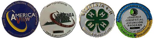
To facilitate awareness of geospatial technologies, the Virginia Geospatial Extension program (VGEP), in partnership with VirginiaView and the National Geospatial Technology Extension Network (NGTEN), developed a geospatial learning activity called the "Virginia Geocoin Adventure." This program is appropriate for 4-H groups, middle and high school classrooms, scout troops, and other formal and informal educational venues. The Virginia Geocoin Adventure uses the hobby of geocaching, in which participants hide and track a traveling coin, also known as a "geocoin" (Figure 1).
Figure 1.
Examples of Geocoins Used in Virginia
The Virginia Geocoin Adventure not only provides participants with exposure to geospatial tools. The program is designed to facilitate STEM career awareness, and provide an entry point to learn more about science and technology, which is a component of the national 4-H science mission mandate (United States Department of Agriculture, n.d.). Leaders can utilize several learning lesson guides that enrich geospatial skills, scientific knowledge, and critical thinking skills. The learning lessons are supported by readily available and free geographic viewers, such as GoogleEarth. The Virginia Geocoin Adventure supports four tier platforms of learning:
- Technology—new technologies that are utilized in current industry, agriculture, and business
- Team building—working in teams, critical thinking, planning and deployment
- Science and Engineering—concepts of GPS, navigation, engineering and math
- Reading and writing—map reading, following instructions, journal writing
Geocaching
The Virginia Geocoin Adventure uses the hobby of geocaching. Participants in this activity, geocachers place small containers or landmarks called "geocaches" in various hidden locations throughout the world. The coordinates of a geocache are recorded using a GPS unit. Other geocachers use these coordinates in their own GPS receiver to navigate to the geocache. Geocachers exchange geocache information on www.geocaching.com. There are over 1,890,000 million geocache locations throughout the world, and over 5 million people participate in this hobby each year (www.geocaching.com).
In addition to finding geocaches, geocachers can place a trackable item, such as a Geocoin or travelbug, in a cache. Other geocachers will pick up the geocoin and take it to another cache. The Virginia Geocoin Adventure uses trackable geocoins. Trackable geocoins have a unique number on each coin. This number is used to log the coin in and out of a geocache. Each trackable coin has its own identity, webpage, and map.
The Virginia Geocoin Adventure
To begin a Virginia Geocoin Adventure, group leaders obtain a Virginia Trackable Geocoin from the Virginia Geospatial Extension Program. The Geocoin Adventure Getting Started Guide is available online at http://virginiaview.cnre.vt.edu/education.html. In Virginia, groups can check out a GPS kit from local 4-H offices if they do not have access to a GPS.
Figure 2.
Overview of the Virginia Geocoin Adventure.
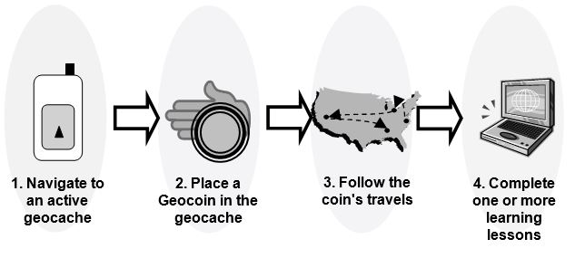
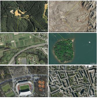
Participants use their GPS receiver (or even a smart phone) to find a geocache near them, navigate to it, and place their trackable geocoin in the geocache. They log their geocoin's location on geocaching.com and then wait for other geocachers to pick up the geocoin and move it to another geocache. Each move of the geocoin is logged on geocaching.com, and participants can track their coin and view any comments made by other geocachers on this website. Geocoin locations can be accessed from a global view or landscape view (Figure 3 and Figure 4).
Figure 3.
The Global View: Tracking a Logged Geocoin Using GoogleEarth
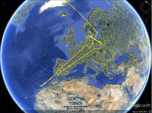
Figure 4.
Tracking Geocoins at a Local Level Using GoogleEarth Enables Participants to Explore and Compare Communities and Landscapes.
Selecting and finding a geocache, placing a trackable geocoin, and watching the geocoin travel are engaging activities that give students a first-hand overview of GPS technology. In addition, travels of these geocoins form a starting point for exploration of additional geospatial and scientific concepts.
Geocaching Learning Lessons
As an enhancement to the learning platforms that geocoins offer, the VGEP and VirginiaView developed four learning lesson activity guides (Table 1) to be used with the trackable geocoins that introduce additional geospatial concepts and incorporate locally relevant critical thinking and decision-making skills. Each learning lesson uses the "stops" that the Virginia Geocoin (or another geocoin) made, as well as Google Earth, a free, online geographic viewer, to teach students a combination of natural resource and ecological concepts, as well as skills in science and math. Curriculum for these lessons can be accessed from the VirginiaView website <http://www.virginiaview.net> under the "educational resources" menu selection.
| Learning Lesson Name | Geospatial Concepts |
| Invasive Species: Gypsy Moth Geocoins | Land use and land cover, basic measurements |
| The Earth's Mosaic: Land Use / Land Cover | Land use and land cover, Remote sensing |
| Watershed Wanderings | Basic measurements, Networks |
| Searching for Patterns: Landscape Ecology | Landscape patterns, Remote sensing image interpretation |
Conclusion
The Virginia Geocoin Adventure provides 4-H groups and other educators with an exciting entry point to introduce basic geospatial concepts and provide opportunities for hands-on activities. Four learning lessons encourage the integration of geospatial literacy and to provide educators with innovative approaches to introduce earth science and natural resource issues. This approach is fully transferable and can be easily adopted by other organizations in other states and countries.
Acknowledgments
Geocoins are made available through partnerships between the Virginia Geospatial Extension Program, Virginia Cooperative Extension 4-H, National Geospatial Technology Extension Network (NGTEN, http://www.geospatialextension.org ), VirginiaView, and the Extending Geospatial Technician Education for Virginia's Community Colleges (EGTEVCC) project. The authors wish to acknowledge the continued contributions of: Kathleen Jamison, Extension Specialist, Virginia Tech; Jeff Kirwan, professor emeritus, Virginia Tech; and Cathy Sutphin, Extension Associate Director, Virginia Tech.
References
Blair, R. B., Meyer, N., Rager, A. B., Ostlie, K., Montgomery, K. L., & Carlson, S. (2004). Best practices for environmental field days: Structuring your event for fun and learning. Journal of Extension [On-line], 42(5) Article 5TOT4. Available at: http://www.joe.org/joe/2004october/tt4.php
Edelson, D. (2012, Summer). Geo-education: Preparation for 21st-century decisions. ArcNews, 34(2) 42. Retrieved from: http://www.esri.com/news/arcnews/summer12articles/files/arcnews34_2/arcnews-summer12.pdf
Foundyller, C. (2009). The GIS/geospatial industry: Forecast for 2010 and beyond despite slowdown in 2009. ACSM Bulletin, 242 (December), 47-48. Retrieved from: http://www.webmazine.org/issues/bull242/
Geocaching. Retrieved from: http://www.geocaching.com
Gewin, V. (2003). Mapping opportunities. Nature, 427(22), 376-377.
McGee, J., & Kirwan, J. (2010). The sky's the limit: Integrating geospatial tools with pre-college youth education. Journal of Extension [On-line], 48(1) Article 1TOT5. Available at: http://www.joe.org/joe/2010february/tt5.php
Milla, K. A., Lorenzo, A., & Brown, C. (2005). GIS, GPS, and remote sensing technologies in Extension services: Where to start, what to know. Journal of Extension [On-line], 43(3) Article 3FEA6. Available at: http://www.joe.org/joe/2005june/a6.php
Shellito, B.A. (2012). Introduction to geospatial technologies. New York: W.H. Freeman and Co.
Skelton, P., Seevers, B., Dormody, T., & Hodnett, F. (2012). A conceptual process model for improving youth science comprehension. Journal of Extension [On-line], 50(3) Article 3IAW1. Available at: http://www.joe.org/joe/2012june/iw1.php
Tomlinson, R. (2003). Thinking about GIS: Geographic information system planning for managers. Redlands, CA: ESRI Press.
United States Department of Agriculture, 4-H National Headquarters. (n.d.). Mission Mandates [Fact Sheet]. Retrieved from: http://www.csrees.usda.gov/nea/family/res/pdfs/Mission_Mandates.pdf