August 2013
|
August 2013 // Volume 51 // Number 4 // Feature // v51-4a5


GIS in Public Planning Agencies: Extension Opportunities
Abstract
This article examines opportunities for Extension professionals regarding GIS functions relevant to planning and applicable for public agencies. The study uses data from two surveys examining perspectives of professionals in Wisconsin's public planning agencies and educators from University of Wisconsin-Extension. The results show that the use of GIS in public planning agencies is mostly limited to routine and administrative tasks rather than more advanced functions of analysis, modeling, and alternative scenario evaluation. Extension educators and specialists could play a critical role, especially by providing training opportunities, in helping these agencies use GIS more effectively.
Introduction
The roles, opportunities, and perceptions that Extension educators in the United States have with regards to geospatial technologies have been given attention (Merry, Bettinger, & Hubbard, 2008b; Milla, Lorenzo, & Brown, 2005; Watermolen, Andrews, & Wade, 2009). Indeed, Extension educators have a unique opportunity to aid communities using these technologies in a range of activities and fields, including agriculture, forestry, conservation, demography, community development, and planning. In this article, I examine these opportunities for functions relevant to urban and regional planning and applicable for public agencies. I base my discussion primarily on a study of geographic information systems (GIS) use in public planning agencies and among Extension educators as well as my experience spanning two decades using and teaching GIS as a specialist, professional planner, and educator.
GIS in Planning: Evidence from Literature
As a planning tool, GIS is here to stay. A simple Internet search performed in July 2012 resulted in over 4 million hits for "planning applications of GIS" and over 28 million for "GIS in planning." Its uses in planning are vast, covering different stages of the planning process, such as identification of problems and opportunities, public participation, and creation and evaluation of proposals. GIS use enhances the display of current conditions, analysis (e.g., detecting change, needs assessment, land suitability, proximity, build-out), three-dimensional visualization, and "what-if?" scenarios, often invaluable to planning practice.
Most empirical work related to GIS use in public planning agencies appeared in the 1990s—when the technology was relatively new to public agencies—and documented that GIS had reached a significant proportion of public planning agencies (Warnecke, Beattie, Kolin, & Lyday, 1998) and that the applications used were largely rudimentary (Budic, 1993; Campbell & Masser, 1992; French & Wiggins, 1990; Gilfoyle & Wong, 1998; Gill, Higgs, & Nevitt, 1999; Tulloch, 1997). These studies showed that GIS was mostly used for data acquisition, information processing, and mapping, rather than advanced analysis or decision-making. Indeed, analytical functions such as land suitability analysis and environmental impact assessments were among the least commonly used applications of GIS and related technologies (French & Wiggins, 1990).
Advances related to hardware and software—most recently Internet-based GIS—in addition to the promotion of geospatial technologies through higher education, increased access to datasets, and a wider adoption of related technologies in agencies have promoted wider adoption and use of GIS among planners and other land-based professionals. Because of this, one would expect that the GIS applications used for planning in public agencies would be varied and sophisticated compared to the early years when GIS was first introduced. Yet even the most recent studies do not paint a hopeful picture of GIS use for planning purposes. In a study of planning professionals in the state of Georgia, Merry, Bettinger, and Hubbard (2008a) found that while around three-quarters of Georgian planners used GIS in their planning process and the majority understood the value of GIS as a land use projection tool, only a modest proportion (16%) of them used GIS for analyzing spatial data and allocating future urban growth areas.
Surveys
In this article, I report from two closely related surveys conducted in 2007 and 2008 in Wisconsin, a state with a rich history of land record modernization dating back to 1980s. These surveys were designed, in part, to understand the extent to which GIS was being used in Wisconsin's public planning agencies, to understand barriers to its use from planners' as well as Extension educators' perspectives, and to identify ways Extension can help mitigate these barriers. Both surveys were designed to be Web-based.
The public agency survey was sent in the summer of 2007 to all planning and planning-related staff in Wisconsin counties, regional planning commissions (RPC), and municipalities with a minimum population of 5,000, and follow-up interviews with 20 respondents were conducted in 2008. The survey received 525 responses, a 44% response rate, and represented 84% of the organizations invited to the survey. In this article, I report the views of 265 practitioners from 121 agencies who worked in a planning, zoning, or community development department with functional GIS and who identified themselves as familiar with GIS. The survey explored whether and how GIS was used in comprehensive planning efforts, the prevalence of different types of GIS applications, the use of planning support systems (PSS), benefits that GIS has brought to the planning departments, and challenges the departments faced in using GIS for planning. The interviews gauged practitioners' opinions on topics such as whether they thought their department was using GIS effectively, additional and advanced applications for GIS use in their department, and what the ideal use for GIS in their department would be.
The survey for Extension educators was sent to 65 county-based educators working for University of Wisconsin-Extension's Community, Natural Resources, and Economic Development program in the summer of 2007. The survey, which replicated some of the questions from the public agency survey, investigated the various planning-related roles that Extension educators have, their GIS familiarity and usage, and their perceptions on GIS use in their jurisdiction, including barriers to use. Thirty Extension educators responded to the survey, 24 identifying themselves as doing planning-related work and familiar with GIS. In this article, I report the views of these 24 educators. Eight of these respondents said they used GIS in their job, three of these on a regular basis beyond solely viewing geospatial data created by others. For the most part, these respondents agreed that when needed they could receive GIS-related products or help with GIS functions from public agencies in their jurisdictions or from University of Wisconsin-Extension GIS state specialists.
Findings
GIS Use in Planning
The survey and follow-up phone calls with agencies that did not participate in the Web-based survey found that the majority of local and regional governments in Wisconsin used GIS. All the RPCs, all the counties, and two-thirds of the municipalities sampled in the survey as well as all of the planning departments that participated in the survey had an in-house GIS in 2007.
The survey revealed that most public planning agencies used GIS in various planning tasks, including simple operations such as accessing parcel information and mapping. A much smaller number engaged in more advanced uses such as land suitability analysis, impact assessment, visualization, public participation, and decision support. Fifteen percent of the respondents suggested that in their planning activities they frequently used at least three of the six GIS advanced applications included in the survey:
- General data analysis
- Site selection
- Land suitability analysis
- Impact assessment
- Visualization
- Public participation.
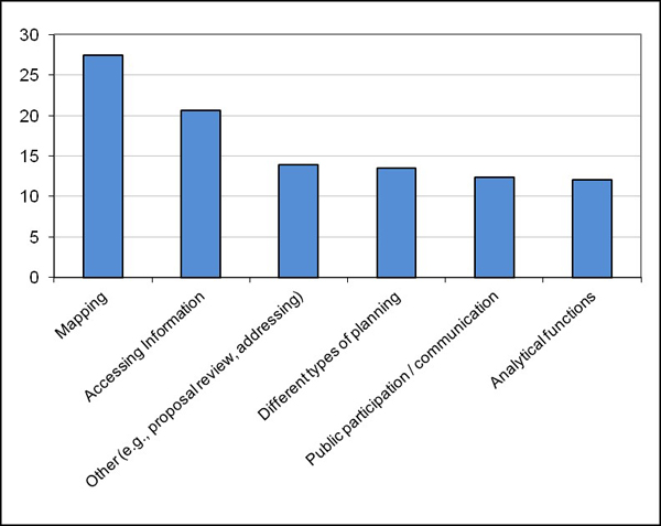
When asked an open-ended question, respondents stated that simpler and routine uses of GIS for applications—such as accessing parcel information and mapping—were the most beneficial planning uses of GIS for their agency (Figure 1). These simple functions overshadowed GIS's analytical benefits, such as the analysis of socio-demographic characteristics, land suitability, impact assessment, and site selection. Similarly, most respondents ranked the use of GIS as a tool to communicate with the public or empower the public in the planning process as less beneficial to their department than mapping and accessing information via GIS. Specifically, just nine respondents (3%) identified Internet mapping (part of public participation/communication in this analysis) as the most beneficial application of GIS in their planning activities, even though around one-half of Wisconsin's public planning agency practitioners indicated that their department used Internet mapping applications on a regular basis.
Figure 1.
Most Beneficial GIS Applications for Planning Departments (Percent of Respondents Indicating Application)
GIS's analytical functions were used mostly for analyzing conditions for rezoning applications, creating buffers to help analyze environmental constraints, and for overlays (which were sometimes used for land suitability analysis). Most of the analytical functions mentioned related to comprehensive planning efforts. A senior planner at a county government where various types of spatial analyses were conducted reported that he and his colleagues conduct mostly reactive data analysis (e.g., as a response to an application for land use change on a property) rather than a proactive and macro-level comprehensive analysis, such as determining "there (are) so many acres of developable land in the county."
The use of GIS for predicting, modeling, and alternative scenario analysis did not appear to be widespread among these public agencies. A few of the interviewees mentioned that their department undertook this kind of work, and a few others mentioned that such work was either outsourced to consultants or were undertaken by other departments (e.g., engineering). GIS modeling and predicting capabilities were most commonly used in the transportation field to predict traffic on highways.
Around half of the respondents stated that their department used in-house GIS to complete a comprehensive plan for their community or another community. In comprehensive planning efforts, while GIS was used by far the most for map making, it was also used—in decreasing order:
- To create and evaluate future growth alternatives
- To conduct demographic and economic analysis, land suitability analysis, and other spatial analysis
- For public participation
- For other applications.
Our interview findings caution us about emphasizing public participation as a use of GIS in planning agencies; the use cited most often was displaying a map created by GIS, which is much different from using geospatial technologies to empower citizens in the decision-making process.
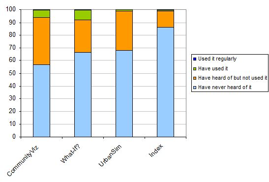
Familiarity with and use of planning support systems (PSS)—tools designed specifically to aid the planning process and planning functions—was very limited among the planning agencies surveyed. This was found despite the perceived benefits to decision-making, productivity, and performance, and a high awareness of and enthusiasm for the capabilities of GIS for planning-related work in the agencies (Table 1). Specifically, over four-fifths of the survey respondents agreed that they themselves or their colleagues were very aware of these capabilities, and one-third agreed that their department was using GIS to its maximum potential.
When the respondents were questioned about their awareness and use of GIS-based PSS, however, the percentages plummeted. The survey found that just three respondents (1%) had regularly used one of the four GIS-based PSS specified in the survey, which have a high profile in the planning field and high visibility in Wisconsin due to substantial advertising campaigns and training opportunities. Most respondents had never heard of these or any other PSS software (Figure 2). Similarly, despite having a high perceived awareness of GIS for planning purposes, Extension educators were not familiar with PSS. Most had not heard about any of the mentioned software, and only one of them had ever used these PSS. However, with some of the PSS programs, planners can now easily conduct analysis and are able to respond to questions like "How much land would be required for single-family residential development in a section of a town if population increased by a certain percentage or the land regulations changed?" or "What will the impacts of alternative scenarios be on the nearby water resources?" While some of these questions can be answered by standard GIS software packages, PSS can be more efficient and accessible to users without advanced analytical skills.
| Planner | Educator | |
| (n = 265) | (n = 24) | |
| GIS improved and facilitated decision-making in my agency / jurisdiction | 70% | 71% |
| GIS improved productivity and performance in my agency / jurisdiction | 69% | 71% |
| There is strong enthusiasm for GIS in my agency / jurisdiction | 90% | 76% |
| I am very aware of the capabilities of GIS for planning-related work | 85% | 90% |
| My colleagues are very aware of the capabilities of GIS for planning-related work | 81% | 67% |
| My agency / jurisdiction is using GIS to its maximum potential | 33% | 43% |
Figure 2.
Awareness and Use of Planning Support Systems (Percentages of Respondents in Planning Agencies)
In interviews with practitioners, it appeared that the most significant planning department needs and desires for GIS in their department involved technological advances as well as applications relevant to the planning process. When asked what GIS uses or application areas they would like to implement in the near future, participants primarily suggested they would like to have improved technical capabilities such as being able to seamlessly carry GIS to the field or to meetings—which current advances will soon make possible for many jurisdictions—and to have access to other agency data. Other future desired uses involved:
- Three-dimensional visualization and modeling
- Heightened analytical capabilities
- Increased public access to data
- The use of mash-ups for decision support and planning support systems in general.
Barriers to GIS Use in Planning
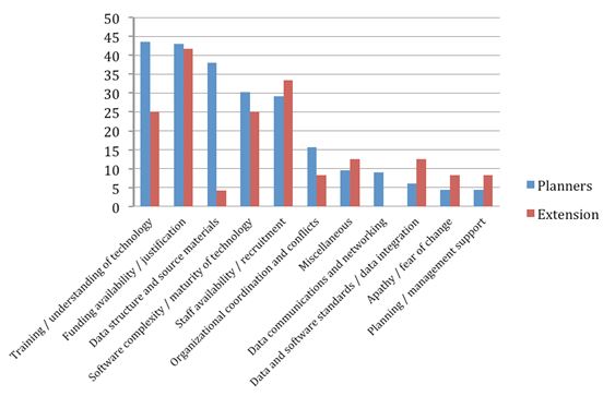
Planners face a multitude of barriers in using GIS in their work, which we discussed in detail in earlier work (Göçmen & Ventura, 2010). According to planners, the most significant of these barriers relates to training and understanding the technology, which encompasses not just a lack of training necessary to learn how to do a GIS function but also insufficient knowledge of what the technologies can offer. Barriers related to funding, data, software, staffing, and organizational coordination follow training-related barriers for planners. Extension educators differed in their perceptions of these barriers to GIS use in public planning agencies in their communities (Figure 3). According to them, the greatest challenges were a lack of funding or an agency's inability to justify the funding. Training-related barriers were deemed to be the third most significant group of barriers by Extension educators, following staff availability and recruitment-related barriers. The study found that Extension educators did not perceive data-related barriers such as the lack of up-to-date, accurate data—barriers that were significant to practitioners—as top barriers to GIS use.
Figure 3.
Top Barriers to GIS Use for Planning Identified by Public Planning Agency Staff and Extension Educators (Percentage of Respondents Indicating Barriers)
Opportunities for Extension Educators and Specialists
Watermolen, Andrews, and Wade (2009) suggested that Extension educators have the most significant roles in training with regards to geospatial technologies. While Extension educators can also be influential in mitigating some other barriers to GIS use in planning, based on my experience and the survey results, I echo the view that Extension educators have the most significant role mitigating training-related barriers. One educator, suggesting that coordination between planners and GIS professionals was also important, stated:
Planning and GIS require two different sorts of skills and intelligences. I am not sure how realistic it is to expect an individual to be highly proficient in both. GIS techs seldom understand what planners need, and planners seldom know how to fully utilize the power of GIS. The successes we've had so far have largely been either basic operations or fortuitous discoveries. I can't help feeling there's so much more we could be doing.
This section focuses on opportunities for training for the above-cited reasons, because other practitioners and scholars have stressed the need for continual training to take advantage of geospatial technologies (Croswell, 1991; Drummond & French, 2008; Gilfoyle & Wong, 1998; Innes & Simpson, 1993; Ventura, 1995), and because the majority of both the practitioners and educators stated in the survey that they would like to receive further training on GIS. A discussion of other opportunities in the areas of mitigating data-related issues or extending GIS to agencies that have not adopted the technology can be found in Göçmen, Ventura, and Seeboth (2010, 2008). In addition, Extension educators can tap into some state-based programs (e.g., Wisconsin Land Information Program, which provides annual grant opportunities for Wisconsin's land information professionals; State of Wisconsin Department of Administration, n.d.), and federal programs (e.g., National Spatial Data Infrastructure Cooperative Agreements Program for up to $70,000; Federal Geographic Data Committee, n. d.) to help mitigate data- and funding-related barriers.
Providing centrally located or community-based workshops that are cost free or reduced cost is important and could significantly increase attendance by community-based planners and other professionals. Both the practitioner and the Extension educator surveys showed that location and cost were factors inhibiting the respondents from attending GIS-related workshops. More specifically, 70% of the practitioners stated that restricted budgets hinder access to much-needed training, and another three quarters stated that travel times beyond 2 hours makes workshops undesirable. Furthermore, focusing on more than one type of delivery and instruction would be beneficial. Watermolen, Andrews, and Wade's study (2009) suggested that a combination of workshops, printed materials, and Internet resources would be the most effective educational approach for Extension educators and their audiences. Our study also echoes the idea that using multiple instruction methods (e.g., workshops, presentations, seminars, Webcasts, printed publications) can increase capacity among practitioners. Some of these instruction methods could be used successfully by an Extension educator with a good understanding of GIS and GIS-related sources but not necessarily technical expertise in specific GIS software.
While the research presented here has drawn on the perspectives of Wisconsin's county-based Extension educators, the opportunities are not limited to educators but extend to Extension's GIS state specialists as well. Indeed, state specialists would complement educators in providing the necessary training and information on GIS uses for planning. Very few educators are experts in GIS (as this research highlighted); because of this, expecting them to provide training on particular functions of GIS or on specific software would not be reasonable in most cases. GIS state specialists, on the other hand, are experts in this technology. If they have planning background, they have the unique ability to offer trainings on particular software or applications and to also offer seminars that show the numerous possibilities of applying GIS in planning and related fields.
In particular, I suggest that in order to increase the use of advanced GIS in planning activities, state specialists design and deliver workshops and seminars that highlight the utility of GIS for analytical, modeling, public participation, and visualization purposes. According to the survey findings and an investigation of training programs throughout Wisconsin, which I believe is true for the nation, a wide range of workshops on GIS functions and applications exist, but training in planning-related GIS applications is limited. In particular, it is worthy to note that ESRI—which provides ArcGIS, the most widely used GIS software—offers a wide range of training. As of December 2012, ESRI's training includes over 100 instructor-led online courses and over 50 instructor-led workshops. In addition, ESRI offers close to 200 online, self-paced training modules. These trainings cover a large variety of topics including working with ArcGIS Server, building Web applications, a comprehensive introduction to ArcGIS software, many analytical capabilities, and "Community Analyst," a tool of potential interest to planning practitioners and Extension educators in community and resource development programs (ESRI, n.d.). Many higher education institutions also provide GIS certificate programs geared to practitioners; similarly software users group or professional organizations for land information professionals, planners, and engineers in many states offer GIS-based training at their annual meetings. Most of these trainings have a fee, some of which are above $1,000. These fees are likely barriers to attaining the training practitioners need; as mentioned above, close to three quarters of the practitioners surveyed stated that restricted budgets hinder access to much-needed training.
For Extensions specialists interested in helping their public planning agencies make more effective use of GIS, I suggest that providing workshops on topics such as socio-demographic and land suitability analyses and impact assessments would be a good start. Similarly, trainings about Internet-based GIS tools would be useful, as these tools have the great potential to enhance public participation (Drummond & French, 2008) and to evaluate different scenarios. It is important, however, to provide information not only about what tools are available and how to use them, but also about how to evaluate them in terms of accuracy of datasets, units of analysis, and underlying assumptions. Such critical evaluation is important since some Internet-based tools make assumptions that can limit their usefulness in ways that are not obvious to users who are not savvy GIS professionals.
Extension educators would also benefit from attending these workshops and seminars, and, in fact, could play essential roles. Because they know the issues in their communities much more than do state specialists, they can initiate and help tailor specific workshops and seminars to be delivered by state specialists and introduce various GIS-related resources in their states and communities. Furthermore, as Watermolen and colleagues (2009) showed, Extension educators can successfully deliver workshops on some of the Internet-based tools.
In summary, Extension educators can play a vital role in increasing advanced GIS use in planning agencies by identifying training needs in their district, introducing practitioners to various training options, and working with Extension GIS state specialists to organize and provide training events.
Acknowledgments
I thank Steve Ventura for his invaluable collaboration on the research, Amy Seeboth for her assistance with conducting the surveys, and Kristine Zaballos for her feedback on an earlier version of this manuscript. This work was supported in part by the Consortium for Rural Geospatial Innovations, funded by the Cooperative State Research, Education, and Extension Services, U.S. Department of Agriculture, and in part by the University of Wisconsin–Madison, College of Agriculture and Life Sciences and University of Wisconsin-Extension.
References
Budic, Z. D. (1993). GIS use among southeastern local governments. Journal of Urban and Regional Information Systems Association, 5(1), 4–17.
Campbell, H. & Masser, I. (1992). GIS in local government: Some findings from Great Britain. International Journal of Geographical Information Science, 6(6), 529–546.
Croswell, P. L. (1991). Obstacles to GIS implementation and guidelines to increase the opportunities for success. Journal of the Urban Regional Information Systems Association, 3(1), 1–15.
Drummond, W. J., & French, S. P. (2008). The future of GIS in planning: Converging technologies and diverging interests. Journal of the American Planning Association, 74(2), 161–173.
ESRI (n.d.). Training. Retrieved from: http://training.esri.com/gateway/index.cfm
Federal Geographic Data Committee. (n.d.). 2013 NSDI Cooperative Agreements Program. Retrieved from: http://www.fgdc.gov/grants/2013CAP/2013CAPDescriptions
French, S. P., & Wiggins, L. L. (1990). California planning agency experiences with automated mapping and geographic information systems. Environment and Planning B: Planning and Design, 17, 441–450.
Gilfoyle, I., & Wong, C. (1998). Computer applications in planning: Twenty years' experience of Cheshire County Council. Planning Practice and Research, 13(2), 191–197.
Gill, S., Higgs G., & Nevitt, P. (1999). GIS in planning departments: Preliminary results from a survey of local planning authorities in Wales. Planning Practice and Research, 14(3), 341–361.
Göçmen, Z. A., & Ventura, S. J. (2010). Barriers to GIS use in planning. Journal of the American Planning Association, 76(2), 172–183.
Göçmen, Z. A., Ventura, S. J., & Seeboth, A. B. (2010). Geospatial data issues in Wisconsin public planning agencies. University of Wisconsin-Extension, Cooperative Extension Publishing. G3872-03.
Göçmen, Z. A., Ventura, S. J., & Seeboth, A. B. (2008). GIS use in Wisconsin's public planning agencies. University of Wisconsin-Extension, Cooperative Extension Publishing. G3872-01.
Innes, J., & Simpson, D. (1993). Implementing GIS for planning: Lessons from the history of technological innovations. Journal of the American Planning Association, 59(2), 230–236.
Merry, K. L., Bettinger, P., & Hubbard, W. G. (2008a). Back to the future part I: Surveying geospatial technology needs of Georgia land use planners. Journal of Extension [On-line], 46(3), Article 3RIB6. Available at: http://www.joe.org/joe/2008june/rb6.php
Merry, K. L., Bettinger, P., & Hubbard, W. G. (2008b). Back to the future part II: Surveying geospatial technology needs of agriculture and natural resources Extension professionals. Journal of Extension [On-line], 46(4), Article 4RIB1. Available at: http://www.joe.org/joe/2008august/rb1.php
Milla, K. A., Lorenzo, A., & Brown, C. (2005). GIS, GPS, and remote sensing technologies in Extension services: Where to start, what to know. Journal of Extension [On-line], 43(3), Article 3FEA6. Available at: http://www.joe.org/joe/2005june/a6.php
State of Wisconsin, Department of Administration (n.d.). Wisconsin Land Information Program. Retrieved from: http://www.fgdc.gov/grants/2013CAP/2013CAPDescriptions
Tulloch, D. (1997). A theoretical model of the lifecycle of community multipurpose land information systems development. Ph.D. Dissertation, University of Wisconsin–Madison.
Ventura, S. J. (1995). The Use of Geographic Information Systems in Local Government. Public Administration Review, 55(5), 461–467.
Warnecke, L., Beattie, J., Kolin, C., & Lyday, W. (1998). Geographic information technology in cities and counties: A nationwide assessment. American Forests and Urban and Regional Information Systems Association, Washington, D.C.
Watermolen, D. J., Andrews, E., & Wade, S. (2009). Extension educators can use Internet GIS and related technologies. Journal of Extension [On-line], 47(5), Article 5FEA21. Available at: http://www.joe.org/joe/2009october/a2.php