April 2013
|
April 2013 // Volume 51 // Number 2 // Tools of the Trade // v51-2tt5


Improving Interactive Workshops: A Case Study of GIS Workshops
Abstract
Traditional training in geospatial technologies consists of lecturing for up to 45 minutes, giving a demonstration, and then assigning a hands-on software exercise. This educational approach, however, can be improved upon to increase learning and retention by adults. In this article, a more active learning design is presented that was used to improve Geographic Information System training workshops for university faculty, staff, and students.
Introduction
Geospatial technology refers to a system that is used to acquire, store, analyze, and output data in two or three dimensions (Reed & Ritz, 2004). It is considered as one of the leading technological areas of the 21st century. It includes geographic information systems (GIS), global positioning systems (GPS), remote sensing, and location-based systems (LBS) (Geospatial Technologies and Homeland Security Symposium & Sui, 2008). These technologies represent valuable tools for professionals of different fields (e.g., natural resource management, agriculture, economic development, planning, engineering, transportation, tourism, public safety, and health) due to the variety of applications that they can offer.
However, these tools are constantly changing, and users require continuing education opportunities to stay current. The Boating and Waterway Planning Program's (BWPP) conducts workshops in geospatial technology to assist resource managers in understanding and using these technologies. The first workshop was implemented in 2007 and focused on geographic information systems (GIS). A comprehensive evaluation of the workshop helped us change the nature of how we create interaction with learners and suggests new strategies that may differ on how Extension faculty might approach "hands-on" learning in the context of GIS training.
Traditional Delivery of a GIS Workshop
Educators know that engaging learners in exploring content is essential for learning to occur. Instructors design workshops, commonly called "hands-on" learning, to enable learners to practice and explore materials. In the context of GIS training, Wheeler (2011) suggests that the instructor typically lectures for up to 45 minutes, giving a demonstration and then assigning a hands-on software exercise. This is how the BWPP also implement its first seven workshops, which basically consisted in providing a series of lectures on ArcGIS Desktop TM follow by natural resource- based exercises (Figure 1). However, "hands-on-learning" or "learning-by doing" does not necessarily imply that learning will actually happen. Indeed, active reflection on the subject matter and application of knowledge are essential to make that experience meaningful and positive (Enfield, Schmitt-McQuitty, & Smith, 2007).
Overall, the evaluation results for the first seven workshops suggested that participants were satisfied with the training program. However, exploratory data analysis of the evaluation questions "Opportunities for interaction with other participants," "Relevance to my work," and "what aspects of the training can be improved" (open- ended question) revealed that, in some instances, insufficient interaction among participants occurred (score below 4.0; five point scale) and that the course content was not always applicable to their personal situations/professions. These two aspects led us to alter the workshop delivery style to address these two key aspects of adult learning (Ota, DiCarlo, Burts, Laird, & Gioe, 2006.)
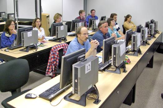
Figure 1.
A Traditional GIS Workshop: Participants Spend More Time Listening to Lectures and Doing Software Exercises Individually.
A More Active Delivery Style
As a response to the issues that arose in the GIS workshop's evaluation, a new, more active delivery style was implemented for the recent five GIS workshops (Figure 2). The workshop was readjusted as follows.
- First, participants interact more by working in small groups to solve scenario exercises.
- Second, additional material—in the form of questions—has been included in the workbook. The questions are presented in different exercises, and solved throughout the training to promote further discussion and to help participants relate workshop content to their own experiences.
- Third, in the most recent workshop (12), a practical final project was added to challenge students to apply all learned concepts and skills, and to discuss the various experiences and difficulties that they encountered while completing the project.
This is a training style that has been suggested by Wheeler (2011) as well, and it provides a greater focus on the student-to-student interaction, which could be very beneficial because, as research shows, it can help students to learn and retain more (TA Consultants, n.d.).
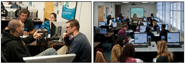
Figure 2.
A More Active GIS Workshop: Participants Work in Small Groups to Solve a Scenario Exercise.
Since implementing adjustments, the answers to evaluation questions "The workshop was relevant to my work," "There were sufficient opportunities to interaction with other participants," and "what aspects of the training can be improved" indicate that, overall, participants were more satisfied (scores above 4) with the level of interaction among students, and there have not been any comments criticizing the training for not being sufficiently relevant to participants' professional disciplines or work needs than was the case for the earlier workshops. Although these results suggest the course is improving with regard to providing the best learning experience possible, we still monitor and assess all workshops and collect the data necessary to continually improve and incorporate relevant active learning elements.
Conclusions
Providing information and asking participants to complete exercises, while technically "hands-on" and engaging, may be insufficient for some adult audiences in the context of geospatial technology. The educational experience can be improved by employing a more active training style that takes into account established principles of adult learning such as the need to know, self-concept, prior experience, readiness to learn, learning orientation, and motivation to learn. The active learning format we employed emphasized increasing interaction among GIS workshop participants, helping them to better relate to the course content and better place it within the context of their own professional needs. Our evaluations suggest these changes have improved the course and increased the likelihood that participants will successfully use GIS technologies in their work.
References
Enfield, R. P., Schmitt-McQuitty, L., & Smith, M. (2007). The development and evaluation of experiential learning workshop for 4-H volunteers. Journal of Extension [On-line], 45(1) Article 1FEA2. Available at: http://www.joe.org/joe/2007february/a2.php
Geospatial Technologies and Homeland Security Symposium, & Sui, D. Z. (2008). Geospatial technologies and homeland security: Research frontiers and future challenges. Dordrecht, Netherlands: Springer. Pg. 1-2.
Ota, C., DiCarlo, C. F., Burts, D. C., Laird, R., & Gioe, C. (2006) Training and the needs of adult learners. Journal of Extension [On-line], 44(6) Article 6TOT5. Available at: http://www.joe.org/joe/2006december/tt5.php
Reed, P. A., & Ritz, J. (2004). Geospatial technology. The Technology Teacher, 63, 17-20.
TA Consultants, Center of Excellence in Teaching and Learning, University of California, Davis. (n.d.). Active Learning. Retrieved from: http://cetl.ucdavis.edu/wp-content/uploads/2010/10/Active-learning.pdf
Wheeler, C. (2011). More interactive learning, less lecturing. ArcUser, 14(1), 64-66.