October 2011
|
October 2011 // Volume 49 // Number 5 // Tools of the Trade // v49-5tt8


Training Organizations in Use of a Modified Stream Visual Assessment Protocol
Abstract
The Stream Visual Assessment Protocol (SVAP) was evaluated as a means to increase watershed surveys in New Jersey. Groups were trained in an SVAP modified for New Jersey streams. Participants in three training workshops were surveyed to determine the usefulness of SVAP as a cost-effective method to evaluate watershed health. Many respondents found that the workshops were helpful due to the "hands-on" aspect and the combination of classroom and field components to the training. Additional technical support and follow up to the trainings was essential to achieve the program's objective of getting additional groups collecting information on watershed health.
Introduction
In New Jersey, approximately 60 grassroots watershed organizations have formed over the past half-century (The Watershed Institute, 2006). Most of these are non-profit and comprised primarily of volunteers. Budgets for these organizations are typically not enough to leverage significant water quality improvement when compared to state agencies or national organizations.
Only about 18% of all subwatersheds in New Jersey have had their health fully assessed (NJDEP, 2009). There is a need for an inexpensive and user-friendly method to assess stream health for groups lacking sufficient resources. Among the tools used to characterize watershed health, the Natural Resources Conservation Service (NRCS) Stream Visual Assessment Protocol (SVAP) provides an excellent option. SVAP is used to characterize stream health, inspire stewardship, educate landowners, and develop watershed improvement projects (NRCS, 1998; Bjorkland, Pringle, & Newton, 2001). It can lead to more advanced monitoring, prioritization of restoration opportunities, and watershed planning.
Many of the Extension efforts in the Water Resources Program at Rutgers University involve providing technical assistance to the surrounding community. Following the principles for working with watershed organizations outlined for Oregon State University's Watershed Stewardship Education Program (WSEP) (Conway, Godwin, Cloughesy, & Nierenberg, 2003), Rutgers Cooperative Extension's (RCE) Water Resources Program works to train local environmental organizations in an SVAP protocol modified to reflect New Jersey's changing landscape.
SVAP Modification and Training
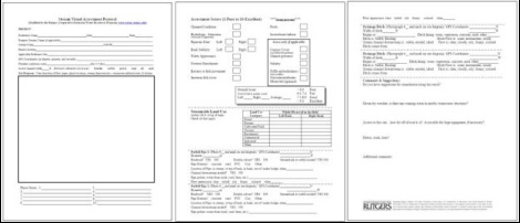
In January 2007, a survey was conducted of New Jersey's 60 watershed organizations and 42% of respondents requested additional workshops on stream assessment. After deciding on using SVAP and to better fit New Jersey's urbanizing environment, RCE modified the NRCS SVAP to include assessment elements to determine impacts from urbanization, including the possible effects of pipe discharges and stormwater ditches on a stream's stability (Figure 1). The modified data sheet now records characteristics of pipes and ditches, as well as their coordinates using a hand-held global positioning system (GPS) (Figure 1). It includes separate scores for the riparian zone and bank stability categories ("right bank" and "left bank") to aid in locating potential sites for future restoration projects (Figure 1).
Figure 1.
The Original NRCS SVAP Data
Sheet (A) and the Rutgers Cooperative Extension Water Resources
Program Modified Version (B)
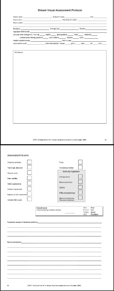
(A)
(B)
Three training workshops were conducted in 2007 and 2008 using the modified SVAP. The first workshop was attended by 32 volunteers from one watershed association. The second and third were attended by 61 people from watershed associations, state and local government agencies, consulting companies, universities, and the general public. Workshops were comprised of a classroom session covering stream ecology and the modified SVAP, followed by outdoor exercises in nearby streams. Attendees were supplied with an SVAP manual, a laminated field identification sheet with example photos for each SVAP category, and a laminated invasive plant species identification guide.
Data Organization
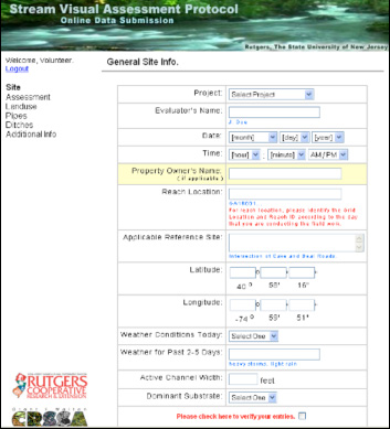
Extension staff organized the resulting SVAP data through an online data entry system established and maintained at Rutgers University. SVAP evaluators were given a login identifier and password to a website that mimics the field data sheet (Figure 2). The online database allows downloads as a series of spreadsheets. Combined with the GPS coordinates recorded by evaluators in the field, data was converted into a geographic information system (GIS) to be projected spatially.
Figure 2.
The First of Six Online Data
Submission Interface Pages Used by SVAP Evaluators
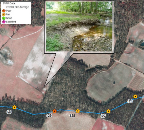
A major outcome of the project was providing organized GIS data to trained organizations. This allows the user to sort through data to identify patterns related to soils, land use, topography, or proximity to major roads. Data can be sorted and organized by a combination of factors (Figure 3), all of which are easily performed in a GIS environment.
Figure 3.
SVAP Data Points Depicted Over
an Aerial Image and a Single Site Exhibiting Poor Bank Stability and
Riparian Health
Technical Assistance
Post-workshop technical assistance was (and continues to be) offered to attendees by phone, email, and site visits in their watersheds by Extension staff. In some cases, training was given to members of watershed associations who were unable to attend the scheduled training workshops. Other examples of technical assistance include preparing field maps of particular watersheds and locating and assessing reference sites which are used as the highest standard for comparison to other reaches when determining assessment scores (NRCS, 1998).
Survey Results
Workshop attendees participated in a survey to evaluate the training program. Survey questions consisted of closed- and open-ended questions and ranking the presentations, presenters, and course content from "unsatisfactory" to "excellent." Additionally, attendees were surveyed by phone after the workshops to identify whether or not they were using SVAP and what barriers, if any, prevented its use.
Results from the surveys were generally positive with the majority of content rated as "excellent." Participants found the combination of classroom instruction and field work to be the most useful aspect to the training, emphasizing the "hands-on" nature of the workshop. Not surprisingly, many of the responses from attendees indicated they planned on using SVAP in their local watersheds. Because the intent of the workshop was to provide tools and technical support, participants were more likely to complete field work when this help was readily available. As noted in the number of stream reaches assessed after the Extension-sponsored program (Table 1), providing follow up technical assistance was successful in achieving the program's objective of getting additional evaluators in the field and collecting information on watershed health.
| Number of Active Evaluators† | ||||
| Watershed Name | Counties | Number of Stream Reaches Assessed | Staff | Volunteers |
| Big Timber Creek | Camden & Gloucester | 10 | 1 | 0 |
| Mantua Creek | Gloucester | 25 | 1 | 1 |
| Oldmans Creek | Salem & Gloucester | 21 | 1 | 0 |
| Raccoon Creek | Gloucester | 7 | 1 | 2 |
| Repaupo Creek | Gloucester | 15 | 1 | 0 |
| Woodbury Creek | Gloucester | 5 | 1 | 0 |
| Musconetcong River | Warren, Morris & Hunterdon | 114 | 4 | 6 |
| Total | 197 | 10 | 9 | |
| † Evaluators as of August 2007 who have been trained to use an Extension-modified SVAP. | ||||
Summary
The value of SVAP is that it requires low cost and minimal training, and encourages stewardship and awareness within a watershed. Due to training offered by RCE's Water Resources Program, several watershed organizations in New Jersey are utilizing this tool to document watershed conditions (Table 1). Additionally, while conducting the SVAP, evaluators reported illegal discharges to the NJDEP, identified invasive species, located vernal pools that would have gone undocumented otherwise, and trained additional people from their own organizations to perform SVAP assessments. In these respects, Extension-sponsored training was able to increase the number of people conducting SVAP assessments and increase areas within New Jersey being assessed for potential water quality improvement projects by following recommendations on multidisciplinary education from the WSEP (Conway et al., 2003). Increasing the number of subwatersheds assessed in New Jersey above the current value of 18% (NJDEP, 2009) will certainly help improve policies and decisions made to protect watershed health by providing data for areas where watershed health is currently unknown.
References
Bjorkland, R., Pringle, C. M., & Newton, B. (2001). A stream visual Assessment Protocol (SVAP) for riparian landowners. Environmental Monitoring and Assessment, 68, 99-125.
Conway, F. D., Godwin, D., Cloughesy, M., & Nierenberg, T. (2003). Watershed stewardship education program—A multidisciplinary Extension education program for Oregon's watershed councils. Journal of Extension [On-Line], 41(4) Article 4FEA4. Available at: http://www.joe.org/joe/2003august/a4.php
Natural Resources Conservation Service (NRCS). (1998). Stream Visual Assessment Protocol. National Water and Climate Center, Technical Note 99-1, Portland, OR.
New Jersey Department of Environmental Protection (NJDEP). (2009). 2008 New Jersey integrated water quality monitoring and assessment report. Water Monitoring and Standards, Bureau of Water Quality Standards and Assessment, Trenton, NJ.
The Watershed Institute. (2006). Locating organizations. Retrieved from: http://www.thewatershedinstitute.org/njwatersheds/locating_groups/