October 2011
|
October 2011 // Volume 49 // Number 5 // Ideas at Work // v49-5iw3


Youth GIS Partnerships in Action: Alert, Evacuate, and Shelter
Abstract
Across the state of Oklahoma, teams of youth and adults have formed to use Geographic Information Systems (GIS) to help prepare their communities for potential emergencies. Oklahoma 4-H teams have selected projects ranging from locating storm sirens to distributing emergency maps. Each of these teams has partnered with a local EMS agency to address a community need while developing their geospatial skills. When conducting 4-H GIS, two goals should be kept in mind: public service and youth development. Partnerships are important to the success of youth and GIS. This program would not be as successful and effective without these partnerships.
Across the state of Oklahoma, teams of youth and adults have formed to use Geographic Information Systems (GIS) to help prepare their communities for potential emergencies. GIS enables the management, storage, and analysis of spatially distributed data. For example, water quality data would be associated with sampling sites; crop yields would be associated with fields or experimental plots (Milla, Lorenza, & Brown, 2005). Oklahoma 4-H teams have selected projects ranging from locating storm sirens to distributing emergency maps. Each team has partnered with a local Emergency Management Service (EMS) agency to address a community need while developing their geospatial skills.
Washington County GIS Club
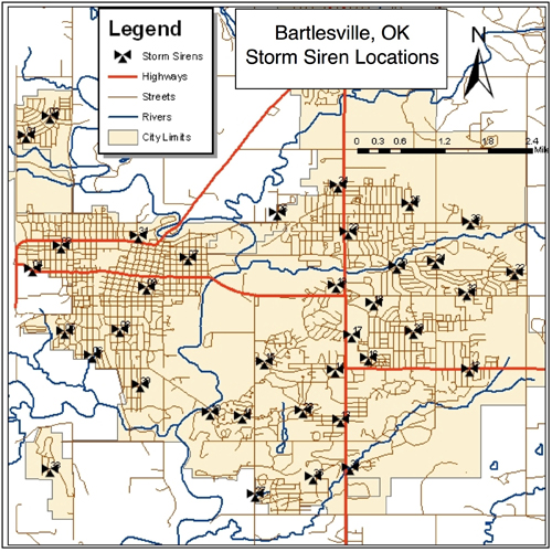
The Washington County GIS Club contacted their local fire department to investigate how they could help prepare Bartlesville, Oklahoma for a potential emergency. The fire department didn't have the latitude and longitude coordinates for the storm sirens in Bartlesville and Dewey, Oklahoma. The team pulled together and quickly located and mapped the storm siren locations. The fire department was so impressed with the work of the youth GIS club, they requested further maps of the fire hydrants in Dewey and Ramona, Oklahoma. Their partnership has greatly contributed to improving the safety of the residents in Washington County, Oklahoma.
Figure 1.
Bartlesville Storm Sirens
Cleveland County 4-H GIS
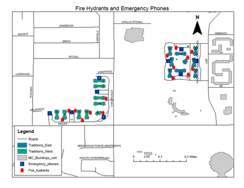
The Oklahoma 4-H program is supported and administered through Oklahoma State University. Cleveland County 4-H broke down the barriers when they partnered with the University of Oklahoma (OU) to help map emergency locations for new dormitories. Cleveland County 4-H GIS Club partnered with the campus police department at the University Of Oklahoma and the OU Center for Spatial Analysis to locate and map the fire hydrants and emergency phones for the Traditions dorms. Upon completion, the maps were presented to the OU police department for public use.
Figure 2.
Traditions Dorm Emergency Phones
and Fire Hydrants
McClain County GeoClovers
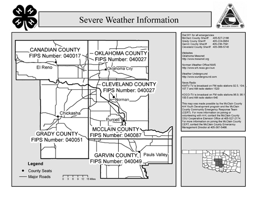
The McClain County Emergency Manager agreed to work with the McClain County GeoClovers to teach them about GIS and emergency management. For the initial project, they located rural fire hydrants near Purcell, Oklahoma. The emergency manager needed to locate the "dry" and "wet" hydrants in the area. The development of the hydrant map led to a partnership with the fire department and expanded the club's emergency preparedness GIS work. The fire department was conducting educational programs to teach the public how to access emergency information during severe weather. To assist, the GeoClovers developed a Severe Weather Information map using Federal Information Processing Standard (FIPS) codes as identifiers for McClain and the surrounding Oklahoma counties. Through the educational outreach, over 800 Severe Weather Information maps were distributed.
Figure 3.
Weather Radio Map
Washita County 4-H
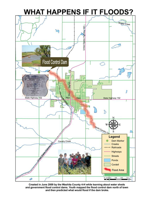
The Washita County 4-H program was one of Oklahoma 4-H's first GIS clubs. They developed one of Oklahoma's first 4-H GIS maps by locating public storm shelters in Washita County. Through that first map they learned there were only three public storm shelters in the county. Since that time, they have partnered with the Corp of Engineers, Natural Resources Conservation Service (NRCS), and the Great Plains Resource Conservation District. The club worked with these agencies along with the public to map illegal roadside dumping sites. Upon completion of their "roadside dump" map, the club used it to create a school-based waste management educational program. Recently, they partnered with NRCS to learn about watersheds. The youth created a "what if" map by analyzing a flood control dam above the county seat and predicting what areas would be affected if the dam broke. Along with conservation issues, several youth are working on a "Welcome Basket" featuring geospatial information of interest to new residents.
Figure 4.
Projected Flood Areas
Oklahoma 4-H GIS Methodology
Oklahoma 4-H has built its GIS program on the basis of partnerships. The first partnership that must be formed in a GIS club is a positive relationship between youth and adults who share a desire to improve their community through GIS. Youth-adult partnerships are a fostered relationship between youth and adults where both parties have equal potential in making decisions, utilizing skills, mutual learning, and promoting change through civic engagement, program planning, and/or community development initiatives (Jones & Perkins, 2004).
The youth and adult partnership is designed to bring the strengths from each side together to form a strong, vibrant educational program that allows adults to see the true value of youth to the community while helping youth develop into caring, productive, community-minded citizens. Youth-adult partnerships are particularly applicable in community mapping projects. Community organizations (such as 4-H) benefit from these partnerships by providing effective educational programs that are beneficial to communities and youth. Members of the community benefit by developing youth who are more prepared to become active members in their communities (Wright, 2000). The participating adults experience the competency of youth firsthand and begin to perceive them as legitimate contributors to society and the decision making process (Innovation Center, 2003).
The second GIS partnership is the combination of a 4-H club and a community organization to address a real community need. Oklahoma 4-H never desires to create a map for the sake of creating a map. Instead, GIS is used to enhance communities and develop technical skills within youth participants. Community partners help find and meet community needs while teaching youth valuable geospatial skills. The last partner in our GIS programs is the public. Each project is designed to involve the public, either through site identification or educational programming. The bottom line is that 4-H GIS projects are for the benefit of the public and communities.
These are a few examples of Oklahoma 4-H GIS projects. When conducting 4-H GIS, two goals should be kept in mind: public service and youth development. Partnerships are vital to the success of youth and GIS. This educational program would not be as successful and effective without these partnerships.
References
Innovation Center for Community and Youth Development and National 4-H Council. (2003). At the table: Making the case for youth in decision-making. Retrieved from: http://www.theinnovationcenter.org/files/Youth_in_Decision_Making-At_The_Table-Report.pdf
Jones, K. R., & Perkins, D. F. (2005). Determining the quality of youth-adult relationships within community-based youth programs. Journal of Extension [On-line], 43(5) Article 5FEA5. Available at: http://www.joe.org/joe/2005october/a5.php
Wright, S. (2000). Youth as decision makers. Ontario: Laidlaw Foundation [Report]. Retrieved from: http://www.laidlawfdn.org/cms/file/YADM-fullreport.pdf
Milla, K. A., Lorenza, A., & Brown, C. (2005) GIS, GPS, and Remote Sensing Technologies in Extension services: Where to start, what to know, Journal of Extension [On-line], 43(3) Article 3FEA6. Available at: http://www.joe.org/joe/2005june/a6.php