August 2011
|
August 2011 // Volume 49 // Number 4 // Tools of the Trade // v49-4tt8


Assisting with Ecological Land Planning: Introducing the Conservation Subdivision Ecological Design and Site Assessment Toolkit
Abstract
Geospatial tools can be helpful in the practice of land use and environmental planning. This article introduces an easy-to-use and cost-free geospatial toolkit that was created to help with the ecological design and evaluation of (open space) conservation subdivision proposals. The article describes the ecological design and site assessment functions and discusses how Extension educators might use it to help planning-related professionals conduct ecological planning in their communities.
Background and Rationale for the Toolkit
Throughout the United States, natural and agricultural lands at the urban fringe are continuously being converted to residential uses. One technique that has become popular in the past two decades as an approach to reducing the conversion of these lands is "open space conservation subdivision design" (often called "conservation subdivision design"), which is touted for preserving environmentally sensitive and significant lands in a subdivision, creating a network of open spaces, and providing water quality benefits (Arendt, 1996, 1999; City of Olympia, 1995; NEMO, 1999).
The primary idea behind a conservation subdivision is simple: residences are clustered on smaller lots than in conventional subdivisions, and the remainder of the subdivision's land is set aside for preservation from further development to benefit residents, wildlife, and plants in the subdivision itself as well as the region as a whole. Arendt, who introduced and popularized conservation subdivision design, recommends that in the design and development of conservation subdivisions, at least 50% of the overall land area be set aside for preservation and neighborhood trails.
However, the limited empirical research on conservation subdivision design shows that in practice, these subdivisions are not uniformly successful in achieving these benefits (Brabec, 2001; Brander, Owen, & Potter, 2004; Lenth, Knight, & Gilbert, 2006; Taylor, Brown, & Larsen, 2007; Williams & Wise, 2006). We believe that several factors, such as inadequate land use regulations, a lack of familiarity with conservation subdivisions, and a lack of tools to facilitate the development of best practices in this area, have contributed to the inconsistent results.
We felt that there was an opportunity to address part of the issue related to a lack of tools based in part on recent research on planners' use of tools such as geographic information systems (GIS) and planning support systems (PSS), which has shown that these tools are not being effectively used (Brail, 2008; Göçmen, 2009; Merry, Bettinger, & Hubbard, 2008). Among the identified significant barriers to use are lack of training, lack of knowledge about what the tools can do for planners, difficulty sparing time to learn and use the tools, and budgetary problems (Esnard, 2007; Göçmen & Ventura, 2010; Vonk, Geertman, & Schot, 2005).
In order to facilitate and improve the conservation subdivision planning process, we have developed a new interactive GIS-based toolkit that is intended to improve efficiency and effectiveness in different stages of the subdivision planning process. The Conservation Subdivision Ecological Design and Site Assessment Toolkit is also intended to mitigate the barriers identified in the literature. It is free, easy to use, and readily available. It can be downloaded from <http://urpl.wisc.edu/people/gocmen/projects.php>.
The toolkit does not require extensive GIS knowledge of spatial analysis or methods of quantifying landscape patterns. The user just needs to be familiar with basic GIS operations and to gather the relevant GIS data for different features. Required GIS data consist of environmental resources, environmental restrictions (i.e., unbuildable areas), the proposed subdivision boundary, and the plan identifying build-up and open space areas. The user also needs to be familiar with minimum open space requirements and conservation goals in his or her jurisdiction.
The toolkit includes self-explanatory and easy-to-use support files, including a ReadMe file, two separate Help files for the two components of the toolkit, and a guide to interpreting the results of the "ecological design" component. The toolkit was developed in ESRI ArcGIS version 9 as an ArcToolbox and has an updated version for ArcGIS 10; further information can be found in the Help files.
Functions of the Toolkit
The Conservation Subdivision Ecological Design and Site Assessment Toolkit has two components, ecological design and site assessment, that can be used separately or together. In a nutshell, the "ecological design" component is intended to help developers, designers, and planners understand the ecological characteristics of the environmental resources falling in and around a proposed subdivision. The "site assessment" component is designed to help planners, local officials, and citizens evaluate a proposed subdivision plan based on local land use regulations and land preservation principles of conservation subdivision design.
In the "ecological design" component, the output is produced with the use of landscape quantification methods known as "landscape metrics" (Figure 1, Table 1). These metrics have been essential for landscape ecologists and can be useful to planners in a number of ways as well. For instance, planners can use landscape metrics to help identify significant environmental resources, to evaluate environmental changes that may have taken place, and to help assess environmental impacts of alternative development proposals. Our ecological design tool treats each environmental resource polygon as a "patch" (i.e., a relatively homogenous area that differs from its surroundings). By characterizing the shapes of individual patches, the tool helps users understand the ecological functions of the patches. (Please note that the tool is accompanied by a guide to interpreting the metrics used.) This insight may help planners and developers to allocate the open spaces in the subdivision that best address local conservation concerns.
Figure 1.
Ecological Design
Component Sample Output
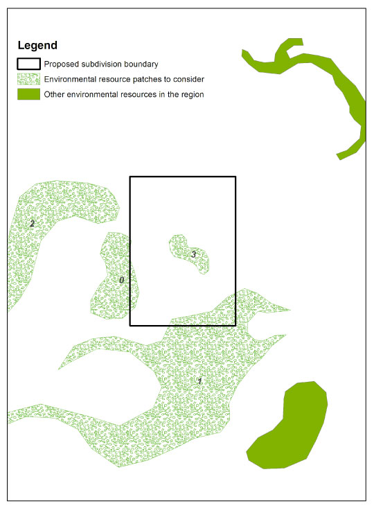
| PatchID | Perimeter | Area | PA_Ratio | ShapeIndex | CoreArea | CA_Index |
| 0 | 6345.47 | 2064486.25 | 0.00 | 1.25 | 348728.51 | 0.17 |
| 1 | 31193.97 | 12861760.62 | 0.00 | 2.45 | 5639322.05 | 0.44 |
| 2 | 12651.62 | 5084740.66 | 0.00 | 1.58 | 1295707.83 | 0.25 |
| 3 | 3467.42 | 555710.59 | 0.01 | 1.31 | 0.00 | 0.00 |
For the "site assessment" component, the tool generates two outputs (Figure 2, Figure 3). The first is a GIS polygon layer which contains the proposed build-up areas where development should be restricted because the land is environmentally sensitive or ecologically significant. The second is a text report, which contains information on whether the proposed subdivision follows the local minimum open space requirements and the extent to which it fails to protect environmentally sensitive or ecologically significant areas.
Figure 2.
Site Assessment
Component Sample Output
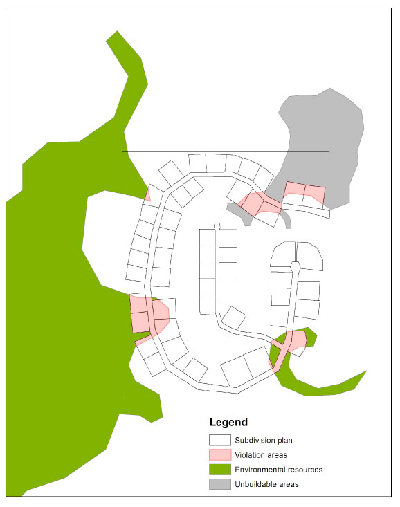
|
Statistics for the proposed subdivision
Area of open space: 141.55 acres (56.34 % of the subdivision),
including: !!!CAUTION: This subdivision proposal VIOLATES the minimum requirement of open space (60 %)!
Area of build-up: 109.68 acres (43.66 % of the subdivision),
including: !!!CAUTION: 15 build-up polygons include ecologically significant and environmentally sensitive areas! |
Implications for Extension
Extension has an exceptional opportunity to assist planning-related professionals with ecological planning through the community development and natural resource protection units throughout the United States. Perhaps the most significant way in which Extension educators can assist practitioners is to familiarize them with the need for ecological planning and with tools to promote ecological planning. The tool we describe in this article is one step toward achieving that goal and can be a useful part of a local educational program.
Acknowledgments
Many individuals have provided invaluable feedback on this work. We particularly thank Jim LaGro, Jack Huddleston, and staff of Waukesha County, WI, Department of Parks and Land Use for their feedback on the development of the toolkit; practitioners for their feedback and effort testing the toolkit; and Brian Ohm for his feedback on an earlier version of the manuscript. Funding has been provided for this research from the USDA Cooperative State Research, Education and Extension Service (CSREES) project WIS01173.
References
Arendt, R. G. (1999). Growing greener: Putting conservation into local plans and ordinances. Washington, DC: Island Press.
Arendt, R. G. (1996). Conservation design for subdivisions: A practical guide to creating open space networks. Washington, DC: Island Press.
Brabec, E. (2001). An evaluation of the effectiveness of cluster development in the Town of Southampton, New York. Urban Ecosystems. 4, 27-47.
Brander, K. E., Owen, K. E., & Potter, K. W. (2004). Modeled impacts of development type on runoff volume and infiltration performance. Journal of the American Water Resources Association. 40(4), 961-969.
Brail, R. K. (ed.) (2008). Planning support systems of cities and regions. Puritan Press, Hollis.
City of Olympia. (1995). Impervious surface reduction study: Final report. Retrieved from: http://www.ci.olympia.wa.us/~/media/Files/PublicWorks/PDFs/WaterResources/Impervious-Surface-Reduction-Study-1995-072407.ashx
Esnard, A. M. (2007). Institutional and organizational barriers to effective use of GIS by community-based organizations. Journal of the Urban Regional Information Systems Association, 19(2), 13-19.
Göçmen, Z. A. (2009, June). GIS use in planning in Wisconsin's public agencies. Paper session presented at the International Conference of Computers in Urban Planning and Urban Management.
Göçmen, Z. A., & Ventura, S. J. (2010). Barriers to GIS use in planning. Journal of the American Planning Association. 76(2), 172-183.
Lenth, B. A., Knight, R. L., & Gilbert, W. C. (2006). Conservation value of clustered housing developments. Conservation Biology. 5, 1445-1456.
Merry, K. L., Bettinger, P., & Hubbard, W. G. (2008). Back to the future part I: Surveying geospatial technology needs of Georgia land use planners. Journal of Extension [On-line], 46(3), Article 3RIB6. Available at: http://www.joe.org/joe/2008june/rb6.php
NEMO (Nonpoint Education for Municipal Officials). (1999). Conservation subdivisions: A better way to protect water quality, retain wildlife, and preserve rural character. NEMO Project Fact Sheet 9. Connecticut Cooperative Extension's NEMO project and the Natural Lands Trust.
Taylor, J. J., Brown, D. G., & Larsen, L. (2007). Preserving natural features: A GIS-based evaluation of a local open-space ordinance. Landscape and Urban Planning. 82, 1-16.
Vonk, G., Geertman, S., & Schot, P. (2005). Bottlenecks blocking widespread usage of planning support systems. Environment and Planning A, 37(5), 909-924.
Williams, E., & Wise, W. (2006). Hydrologic impacts of alternative approaches to storm water management and land development. Journal of the American Water Resources Association. 42, 443-455.