August 2009
|
August 2009 // Volume 47 // Number 4 // Tools of the Trade // v47-4tt3


Web Soil Survey: A New Horizon in the Use of Site-Specific Soil Data
Abstract
The USDA-NRCS Web Soil Survey (WSS) is
a new electronic version of the Soil Survey that includes
soils of all 50 states with the same great content but in a
searchable, interactive format that is quick and efficient to use.
Once you have found the site-specific soil information you need, WSS
provides you a checklist to select the categories of information you
want to develop into a professional-looking printable map and report
that can also be saved in Adobe Acrobat (.pdf) format. This article
shows you where to access the WSS on the Internet and how to get
started.
Introduction
Soil is "the collection of natural bodies in the earth's surface, in places modified or even made by man of earthy materials, containing living matter and supporting or capable of supporting plants out-of-doors" and is the foundation for everything we do (Soil Survey Staff, 1973). Soil includes the very thin surface layer of the earth's crust that differs from underlying rock material as a result of interactions through climate, living organisms, time, relief, and parent material. In the modern era of precision agriculture with the advent of field-specific management practices, it is imperative that farmers, consultants, and researchers alike be able to realize the spatial variability of soil. For example, within-field variability of yield, soils, topography, soil electro-conductivity, and other similar variables are critical factors that one needs to understand to be successful in current production agricultural systems.
The characterization of soil properties is a daunting task at best. In the past, farmers have relied upon hard-copy published soil surveys that were produced in the 1940's through the 1980's. When these soil surveys were created, their primary purpose was for "land-planning" such as drainage and erosion control and contained predictions of soil behavior for selected land uses. They also highlighted limitations and hazards inherent in the soil, improvements needed to overcome limitations, and the impact of selected land uses on the environment.
Even though yield potential was a part of these predictions, they were/are very subjective in nature. The ultimate objective of soil surveys is to improve the producers' knowledge of the soil landscape so that land-use decisions can be based on factual information (Morris, Ross, & Johannsen, 2008). One tool that has been developed to meet this need is the Web Soil Survey (WSS), which allows efficient and accurate characterization of site-specific soil properties and conditions.
Web Soil Survey
The USDA-NRCS Web Soil Survey (WSS) is an Internet Web-based version of the local (parish or county) soil survey book that has been used for decades. The WSS provides the most current soils information, allows the user to get only the information needed, and eliminates the cost of hard-copy publishing. WSS allows a user to select the area of interest, which could be as specific as a field or farm, and allows the user to produce custom-made soil maps and interpretations for the defined area. If, after reviewing the soil survey report, users still have unanswered questions about the survey in their area of interest, they can contact the nearest NRCS or conservation district office. A brief description follows of where to access the WSS and how to get started.
How to Use Web Soil Survey
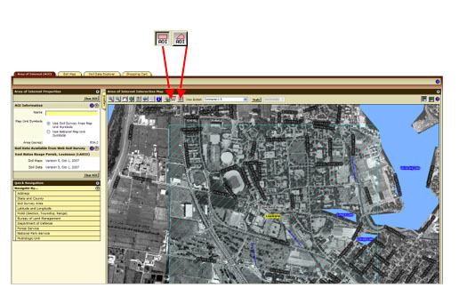
The Web Soil Survey can be accessed via the link <http://websoilsurvey.nrcs.usda.gov/app/>. Once at the homepage, click the green "Start WSS" button near the top. Once you are directed to the mapping page, you must select an area of interest (AOI) to view the soils information. The AOI can be determined by street address, county and state, soil survey area, latitude and longitude, section, township and range, federal land boundaries, or hydrologic unit. The user can also click on the United States map and continue to zoom in to locate the AOI, (e.g., field, farm, etc.) or draw a box around the area of interest. As seen in Figure 1, there are two ways to define the AOI for soils information. The red arrows in Figure 1 indicate that the icon for irregular fields was selected (right), or the other option is the icon just to the left by which a user can select a rectangular area.
Figure 1.
Selecting the Area of Interest in Web Soil Survey (Red Arrow Points to AOI Icons)
As you are clicking to define your area a red line will outline the area of interest. The line will then turn to light blue once the area is defined. After that, select tabs for the information you want. The Soil Map tab (selected in Figure 2, indicated by red arrow) allows you to view the soil series mapped on the property. The associated table lists the soil series' names and the acres of each series mapped. You can select the soil series within the table and a list of properties will appear that gives information about the texture, depth to limiting layer and other features about the soil.
Figure 2.
Viewing Soil Series Information for the Area of Interest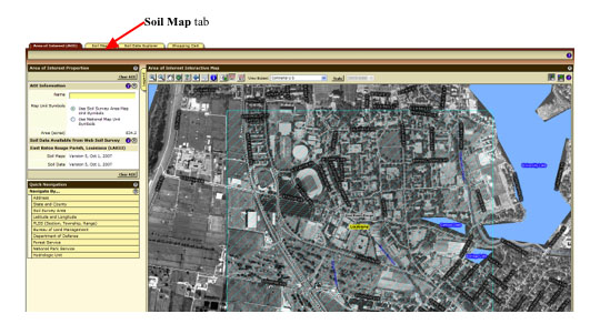
One of the more powerful features of WSS is the Soil Data Explorer tab (Figure 3), which gives information about land use suitability and limitations. The first sub-tab under Soil Data Explorer is Intro to Soils, and among other items this contains a dictionary of soil terms that may be useful. The second tab is Suitabilities and Limitations for Use, which provides a text-based description and maps of the properties and limitations for various uses. The next tab to the right is Soil Properties and Qualities and includes information about soil chemical properties, soil erosion factors, soil physical properties, and soil quality (Figure 3). View Rating provides a visual map with the associated tables. The last tab to the right is Soil Reports, which allows the user to select the particular land use issue and develop a map and report. Soil reports are listed by category and allow the user to select a soil feature or land use issue to develop a complete report in a printable version. Currently, maps and reports from the Web Soil Survey are delivered in Adobe Acrobat (.pdf) format.
Figure 3.
Soil Data Explorer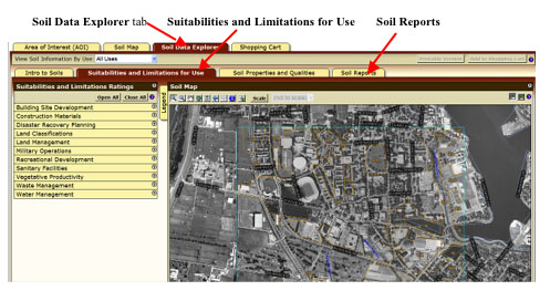
Soil Survey Limitations
While the soil survey is clearly one of the most valuable and sometimes indispensable tools we have, it does have certain limitations that should be noted. For example, soil map units may have inclusions of up to two acres that do not fit within the use and limitations for the series that is labeled. This is due to the scale at which the maps were originally created. Therefore, onsite soil examination and testing are sometimes necessary to determine soil suitability for intensive use of small areas or individual fields. The other limitation is that soil mapping is a continual process in that soil survey reports age; some parts may continue to accurately reflect existing soil conditions and other parts may lose their utility. For example, precision leveling of a particular site may change the accuracy of a given area.
What's Ahead?
As stated earlier, map products from the Web Soil Survey are delivered in Adobe Acrobat (.pdf) format, and one can currently download spatial data sets from Soil Data Mart for the particular county/parish; however, within the year, maps and reports for a particular AOI will be available in a geographical information system (GIS) format, thereby adding greatly to their utility for a number of applications, including precision agriculture and natural resource conservation.
References
Morris, D. K., Ross, K. W., & Johannsen, C. J. (2008). The characterization of soil properties to develop "soil management/mapping units" using high-resolution remotely sensed data sets, Journal of Terrestrial Observation. 1 (1) Retrieved August 13, 2009 from: http://docs.lib.purdue.edu/jto/vol1/iss1/art4
Soil Survey Staff, (1973). Soil survey manual. United States Department of Agriculture, Washington, DC.
Soil Survey Staff, Natural Resources Conservation Service, United States Department of Agriculture. (2006) NCSS soil Web survey. Retrieved August 13, 2009 from: http://websoilsurvey.nrcs.usda.gov/app/