October 2008 // Volume 46 // Number 5 // Tools of the Trade // 5TOT5
Stakeholder Education About the Designation of Coastal Zones for the Protection of the Florida Manatee (Trichechus manatus latirostris): The Manatee Awareness and Protection Resource (MAPR) Web Site
Abstract
In Florida, boaters often have close encounters with Florida manatees (Trichechus manatus latirostris), a protected marine mammal. Manatee protection zones are established to regulate boating traffic in coastal areas where manatees may be at risk of injury. Public debate over the demarcation of the zones is acrimonious. The Boating and Waterways Management Program of Florida Sea Grant created the Manatee Awareness and Protection Resource (MAPR) Web site to promote stakeholder education and awareness surrounding the designation of manatee protection zones. The Web site includes an interactive map that allows visitors to visualize some of the factors involved in delineating manatee protection zones.
Introduction
A contentious management issue in Florida involves balancing protection of the Florida Manatee (Trichechus manatus latirostris) with human use of coastal waters. Public debate surrounding the issue is acrimonious, often pitting environmental interests against those of boating and fishing. The polarization of the debate makes it increasingly important to expand public awareness and education regarding how manatee protection zones, a type of marine protected area, are classified and demarcated throughout Florida waters. Providing stakeholders and the public with an interactive visualization tool to view and interpret relevant information--whether regarding manatees, habitat, or boats/boaters--will engender a greater understanding and appreciation of this complex management issue, possibly leading to greater acceptance of and compliance with protection zone restrictions.
Florida Sea Grant's Boating and Waterways Management Program (BWMP) Extension faculty were funded by the National Oceanic and Atmospheric Administration's Coastal Services Center to develop a visualization tool incorporating geographic information and educational modules that explore factors important to the delineation of manatee protection zones in Florida. As part of this effort, a public education Web site was developed.
Manatee Awareness and Protection Resource (MAPR) Home Page
Students and faculty in the University of Florida Digital Media Art Program and the Mint Graphic Design Studio collaborated with Florida Sea Grant to design the Manatee Awareness & Protection Resource (MAPR) Web site <www.flmapr.org>. MAPR uses interactive graphics and maps to illustrate and describe important factors considered in the designation of manatee protection zones in Florida's coastal waters.
The left screen shown in Figure 1 below depicts the MAPR home page. The text box titled "Welcome to MAPR!" explains the purpose of the Web site and invites visitors to begin exploring by moving their cursor over the various icons depicted in a representational cross-section of a Florida coastal area. Any of the features depicted can be selected to access more information. Each of these topical reviews includes citations to current peer-reviewed scientific literature or reports of research projects. The icons, and what they represent, include: (a) a government building (legislation for manatee protection); (b) a power plant (warm water aggregation sites); (c) a dock (effects of coastal development); (d) a navigation sign (manatee protection zones); (e) two manatees (manatee facts); (f) seagrass (aquatic vegetation); (g) water (aquatic habitat); and (h), a boat (effects of boating).
Figure 1.
MAPR Home Page
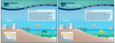
The view on the right in Figure 1 shows the screen after a visitor to the Web site selects the manatee icon. The scrollable text box is titled "Manatee Facts" and contains basic information regarding manatees. A link to "more information" about manatees is available at the end of the basic text. This information was gleaned from a review of current literature (e.g., Haubold, Deutsch, & Fonnesback, 2006; Reep & Bonde, 2006). The format for the manatee icon is typical of other topics, and similar reviews were written for these areas as well, including the results of research by University of Florida Sea Grant BWMP extension faculty (Sidman & Flamm, 2001; Sidman, Fik, & Sargent, 2004; 2005; 2006).
Early stages of the MAPR project explored the feasibility of a spatial decision support system (SDSS) to help identify and evaluate manatee protection zones. While effort was made towards developing a SDSS, ultimately, it was not pursued because scientific partners agreed that such a system was premature given the current state of knowledge. The results of this effort included the assembly and formatting of spatial information about Lee County, Florida. These were put to good use as a case study on the Web site, which represents the heart of MAPR. Lee County includes part of Florida's largest estuary (greater Charlotte Harbor), is home to an estimated 38% of Florida's manatees, and is one of the state's most popular boating regions.
The MAPR GIS/Interactive Map
A link to the case study labeled "GIS/INTERACTIVE MAP" is located in the lower left corner of the home page (Figure 1). When selected, an interactive map opens, allowing visitors to explore and learn more about the geographic information relevant to manatee protection efforts (Figure 2).
Figure 2.
The GIS/Interactive Map
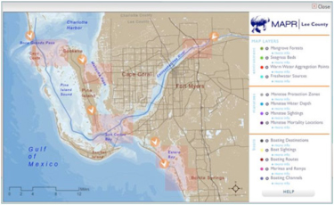
The interactive map incorporates basic Geographic Information System (GIS) functionality that allows a user to display and overlay various related data themes. The user can simply click in the legend to turn on data layers (mangrove forests and manatee sightings, for instance) to display features on the map. Clicking the "more info" link for each data theme in the legend provides insights into that layer's origins and significance. Figure 3 shows boating destinations layered with seagrass beds for Lee County.
Figure 3.
Distribution of Seagrass Beds and Boating Destinations in Lee
County, Florida
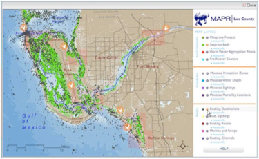
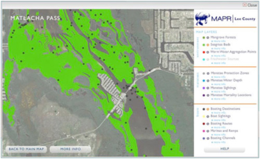
The map highlights six locations in Lee County (Boca Grande, Matlacha Pass, San Carlos Bay, Caloosahatchee River, and Estero Bay--north and south areas). The user may pause the cursor over one of the locations to either display options for more information, or open a map that is zoomed to the area. "More information" describes the local area and its relevance to manatees, and "zoomed in map" opens a detailed view of the location with aerial photography as a base map. The user can explore the relationships among various data layers in the zoomed map by turning them "on" or "off" in the legend. Figure 4 shows the distribution of boating destinations and seagrass beds for Matlacha Pass.
Figure 4.
Distribution of Seagrass Beds and Boating Destinations in
Matlacha Pass
Additional Web Site Content
Visitors also can access additional site content from the home page via the navigation links located on the blue banner near the top of the home page (Figure 1). "GIS/MAP"links to a brief tutorial on GIS theory and its application to manatee issues. "RESOURCES" includes a downloadable PDF of all site content and a bibliography of references cited. "CONTACTS" provides information about the organizations that created the site, and a means for site visitors to send feedback to Florida Sea Grant. The "SITE MAP" is a list of direct hyperlinks to the Web site's main sections. "HOME"always returns the visitor the home page.
Acknowledgements
The following organizations contributed to the development of the MAPR Web site: Florida Sea Grant, University of Florida Digital Media program <http://www.arts.ufl.edu/ART/Programs/digitalMediaGrad.asp> and Mint Graphic Design Studio <http://www.ufdesigners.com/main/?page_id=15>, the Florida Fish and Wildlife Conservation Commission, the FWC Fish and Wildlife Research Institute, Mote Marine Laboratory, the Lee County Division of Natural Resources, and the South Florida Water Management District.
References
Haubold, E. M., Deutsch, C., & Fonnesback, C. (2006). Final biological status review of the Florida manatee St. Petersburg, FL: Florida Fish and Wildlife Conservation Commission, Florida Wildlife Research Institute.
Reep, R. L., & Bonde, R. K. (2006). The Florida manatee: Biology and conservation. Gainesville, FL: University of Florida Press.
Sidman, C., Fik, T., & Sargent, B. (2004). A recreational boating characterization for Tampa and Sarasota Bays (Rep. No. Florida Sea Grant Publication TP-130). Gainesville, FL: Florida Sea Grant, University of Florida.
Sidman, C., & Flamm, R. (2001). A survey of methods for characterizing recreational boating (Rep. No. Florida Sea Grant Technical Paper 109). Gainesville, FL: University of Florida.
Sidman, C., Swett, R., Fik, T., Fann, S., Fann, D., & Sargent, B. (2005). A recreational boating characterization for the greater Charlotte Harbor (Rep. No. Florida Sea Grant Publication TP-150). Gainesville, FL: Florida Sea Grant, University of Florida.
Sidman, C., Swett, R., Fik, T., Fann, S., & Sargent, B. (2006). A recreational boating characterization of Sarasota County (Rep. No. Florida Sea Grant Publication TP-152). Gainesville, FL: Florida Sea Grant, University of Florida.