June 2008 // Volume 46 // Number 3 // Tools of the Trade // 3TOT6
Identifying Agriculture and Forestry Educational Needs Using Spatial Analysis Techniques
Abstract
The development and delivery of effective educational programming requires the identification of community needs. This article introduces a relatively simple method for integrating Agricultural Census data with a geographic information system to summarize farm characteristics at multiple scales. A case study of Tennessee farm and forest data illustrates how this method can help prioritize Extension and outreach efforts to most efficiently address landowner needs. Results indicate the applicability of this method for focusing educational efforts in areas where programs can optimize agricultural profitability and environmental quality.
Introduction
As public agencies are increasingly faced with limitations in funding and staff, the need to prioritize Extension and outreach efforts becomes increasingly evident. While there is an increasing need for educational programs in both urban and rural communities, many face difficulties in identifying the audiences that would benefit most from issue-specific instruction. Additionally, the significance of onsite meetings and hands-on instruction for agriculture and natural resource education (Trede & Whitaker, 2000) illustrates the need for Extension educators to understand spatial variation in agricultural practices.
Comprehensive needs assessments have long been used by Extension personnel to identify issues relevant to local audiences (Etling, 1995). These approaches often utilize census data in addition to surveys, key informant interviews, nominal group processes, and other tools to prioritize the needs of Extension audiences (Caravella, 2006). However, recently developed geographic information systems (GIS), coupled with readily accessible, nationally standardized data provide new opportunities to rapidly identify the educational needs of communities at a finer scale.
Need assessment processes may be particularly important for providers of educational programs geared toward producers of specialty agricultural products and commodities that are regulated under environmental permits (Clay, Ren, Reese, Waskom, Bauder, Mesner, Paige, Reddy, Neibauer, & Mahler, 2007). For example, National Pollutant Discharge Elimination System (NPDES) permits of many livestock producers require best management practices be implemented to prevent water pollution. Livestock waste management Extension specialists can greatly benefit from an enhanced understanding of where these types of facilities are located. This may be of particular important considering recent findings of the potential impacts of agricultural Extension and environmental education on water quality BMP installation by farmers (Benham, Braccia, Mostaghimi, Lowery, & McClellan, 2007).
Also, the success of forestry and natural resource educational programs is largely dependent upon the identification of forest landowners (Kuhns, Brunson, & Roberts, 1998). Given the increasing opportunity cost of conserving woodlands, farmers and landowners stand in greater need of options to maintain the economic viability of private forests (Alig, 2007). While Extension foresters are often able to provide valuable information on forest management and marketing, large-scale Extension programming requires the identification of farms that include large woodlots. The identification of farms with extensive woodlots is important, particularly regarding landowner adoption of innovative nonindustrial private forest management practices, such as certification (Mercker & Hodges, 2007).
Methods
While many applications of geospatial technologies for Extension educators have been previously described (Milla, Lorenzo, & Brown, 2005), this article introduces a novel technique for educators to access apply these tools for program planning. Although the practicality of complex GIS applications for Extension education is sometimes questioned (Samson, 1995), the simple methods described here are well within the capabilities of many field offices.
The United States Department of Agriculture (USDA) National Agricultural Statistics Service (NASS) conducts the Agricultural Census every 5 years. This survey is mailed to farmers and ranchers to determine a number of characteristics regarding agricultural operations (USDA NASS, 2008). Recent and historical results are publicly available via <http://www.nass.usda.gov>. This information can be summarized at the national, state, county, and zip code levels. Data from the 2002 Agricultural Census were downloaded for all Tennessee zip codes in CVS (comma delimited) format. Microsoft Excel was used to prepare the attribute table for input into a GIS.
The CVS file was reformatted into DBF IV (database IV) format. This was added as a table into ESRI ArcMap 9.2 and joined by attributes to a shapefile of Tennessee zip codes. This brief process enabled graphical visualization of Agriculture Census data.
Results and Implications for Educators
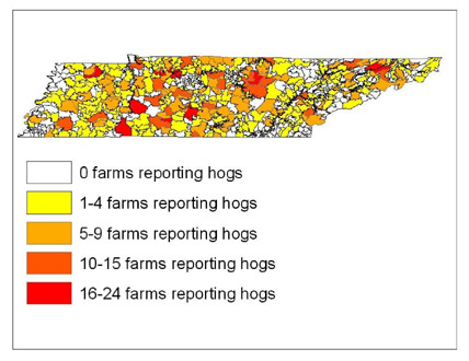
The geographic distribution of livestock producers is an important characteristic for designing and planning agricultural education programs. While a great amount of Extension program planning is done at the county-level, one of the purposes of this study was to illustrate the potential for Agricultural Census data to provide greater detail than traditional county-level estimates. The methods described in this paper can be applied to summarize agricultural attributes at regional, state, county, or zip code scales. For the purposes of this case study, maps were developed that illustrate the spatial arrangement of swine producers across Tennessee zip codes (Figure 1).
Figure 1.
Tennessee Swine Producers by Zip
Code, as Reported by the 2002 Census of Agriculture
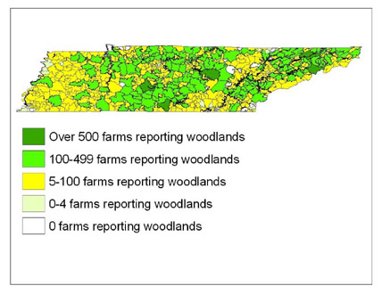
Additionally, successful design and delivery of natural resource Extension programs is dependent upon the identification of receptive audiences. Given the familiarity of many agricultural producers with Extension education, farms containing extensive woodlots may be ideal for delivery of forestry education programs. Forest management practices that improve environmental quality, such as agroforestry and forest certification, may be most successful if implemented on farms that contain large forested tracts (Udawatta, Krstansky, Henderson, & Garrett, 2002). Therefore, a map was developed that illustrates the distribution of Tennessee farms reporting woodlots (Figure 2).
Figure 2.
Tennessee Woodlands by Zip code,
as reported by the 2002 Census of Agriculture
This case study helps to illustrate the significance of integrating a spatial perspective into Extension program planning. While various forms of media present great opportunity to put agricultural and natural resource research in the hands of farmers and private landowners, the process described here offers a simple method to use publicly available data to make the most efficient use of Extension tools.
Additionally, the upcoming release of 2007 Agricultural Census data should provide additional insight into the characteristics of agricultural communities. Great potential exists to examine change in agricultural practices and subsequently Extension audiences. In summary, while audiences are changing rapidly, the integration of spatial analysis tools and census data provides opportunities for planners to identify where specific educational programs should be targeted.
References
Alig, R. J. (2007). A United States view on changes in land use and land values affecting sustainable forest management. Journal of Sustainable Forestry, 24(2/3): 209-227.
Benham, B. L., Braccia, A., Mostaghimi, S., Lowery, J. B., & McClellan, P. W. (2007). Comparison of best management practice adoption between Virginia's Chesapeake Bay Basin and Southern River Watersheds. Journal of Extension [On-line], 45(2) Article 2RIB3. Available at: http://www.joe.org/joe/2007April/rb3.shtml
Caravella, J. (2006). A needs assessment model for Extension educators. Journal of Extension [On-line], 44(1) Article 1TOT2. Available at: http://www.joe.org/joe/2006february/tt2.shtml
Clay, D. E., Ren, C., Reese, C., Waskom, R., Bauder, J., Mesner, N., Paige, G., Reddy, K., Neibauer, M., & Mahler, R. (2007). Linking public attitudes with perceptions of factors impacting water quality and attending learning activities. Journal of Natural Resources and Life Sciences Education, 36: 36-44.
Etling, A. (1995). Needs assessment: A handbook. Journal of Extension [On-line], 33(1). Available at: http://www.joe.org/joe/1995february/tt1.html
Kuhns, M. R., Brunson, M. W., & Roberts, S. D. (1998). Landowners' educational needs and how foresters can respond. Journal of Forestry, 96(1): 38-43.
Mercker, D., & Hodges, D. (2007). Forest certification and nonindustrial private landowners: Who will consider certifying and why? Journal of Extension [On-line], 45(4) Article 4RIB6. Available at: http://www.joe.org/joe/2007august/rb6.shtml
Milla, K. A., Lorenzo, A., & Brown, C. (2005). GIS, GPS, and remote sensing technologies in Extension services: Where to start, what to know. Journal of Extension [On-line], 43(3) Article 3FEA6. Available at: http://www.joe.org/joe/2005june/a6.shtml
Samson, S. A. (1995). Determining need for a geographic information system. Journal of Extension [On-line], 33(5). Available at: http://www.joe.org/joe/1995october/tt2.html
Trede, L. D., & Whitaker, B. S. (2000). Educational needs and perceptions of Iowa beginning farmers toward their education. Journal of Agricultural Education,41(1).
Udawatta, R. P., Krstansky, J .J., Henderson, G. S., & Garrett, H. E. (2002). Agroforestry practices, runoff and nutrient losses: A paired watershed comparison. Journal of Environmental Quality, 31: 1214-1225.
United States Department of Agriculture - National Agriculture Statistics Service. (2008). National Agricultural Census questions and answers. Retrieved May 1, 2008, from http://www.agcensus.usda.gov