October 2007 // Volume 45 // Number 5 // Tools of the Trade // 5TOT3
The Brown County Online GIS: An Example of a Multi-Agency Collaborative Mapping System
Abstract
One of the benefits of an online Geographic Information System (GIS) is that it allows many different organizations and individuals to utilize a GIS without actually having the software and data on their computers. This article explains how Brown County Kansas and Brown County Extension developed an online GIS to improve emergency preparedness in such a way that multiple agencies and the public could also benefit.
Introduction
A Geographic Information System (GIS) is computer software that can display, manipulate, and query spatially referenced maps and data (Purcell, Ponomarenko, & Brown, 2006). As the power of personal computers has continued to increase and the cost to decrease, GIS systems are becoming increasingly common. From an Extension education standpoint, GIS has become an extremely important technology for agriculture, natural resources, and other programming areas (Milla, Lorenzo & Brown, 2005), including 4-H.
Despite its increasing utility, one of the initial barriers to implementing a local GIS system is software and data cost. While there are many examples of free GIS software such as Environmental Systems Research Institute's ArcExplorer program, these systems are usually limited in their capabilities. An even bigger barrier is the acquisition and maintenance of current GIS data and imagery.
Despite these barriers, many public agencies are discovering GIS capability is crucial to their purpose. Consequently, it is very common for multiple public agencies to be buying, developing, and maintaining nearly identical GIS systems (Stuver, 2002). This situation is even found on university campuses, where multiple departments are paying for individual software licenses. While individual licenses may be cheaper at a department level, the cumulative cost to a university can greatly exceed that of a single campus-wide license.
A similar situation is commonly found in county governments. A sheriff's department may need to maintain a GIS system and data to support its 911 system. An emergency management department may need a GIS to support its disaster planning and response efforts. A county Extension program may need a GIS to support agriculture initiatives.
Although each department has a unique mission, to a large extent, they all share similar mapping needs. The development of a single GIS system and dataset, shared among departments, could result in huge financial savings for the county. Such a system could also provide GIS for programs and individuals that might not otherwise be able to afford it.
A Collaborative Online GIS
In 2005, the Brown County Local Emergency Preparedness Committee (LEPC) in Kansas identified improved 911 mapping and routing as a critical need. Unfortunately, the sole beneficiary of this data would be the Sheriff's Department, which maintains the 911 system. How could a single system be developed that would serve the needs of multiple agencies?
The LEPC invited K-State Research and Extension of Brown County to be part of a committee tasked with developing a better system. It was decided to pursue the potential of a Distributed GIS (DGIS) system. In a DGIS, the software resides on a central server(s), and GIS information is served out to "clients" via their Web browser. Essentially, the DGIS turns a client's Web browser into a virtual GIS.
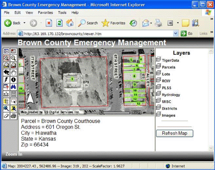
Figure 1.
The Brown County Online GIS
System Works by Turning a Computer's Web Browser into a Virtual GIS.
Buttons on the Left of the Screen Manipulate and Query Data in the
Layers Displayed on the Right.
The committee prioritized the various GIS layers that would be developed for the online system. Brown County then hired a vendor to develop and host the online GIS. It was decided to contract these services because of the cost and time savings that would be realized. Although the Brown County Extension program has extensive GIS capability, the time required to develop the basemaps would be enormous.
It cost about $100,000 to develop the basemaps and approximately $400 a month for the system to be hosted by the vendor. While this may seem expensive, development time was reduced to months rather than years. Because the system and data are hosted and maintained by the vendor, the need to hire a local GIS technician(s) was eliminated. This arrangement conservatively saves the county $50,000 a year.
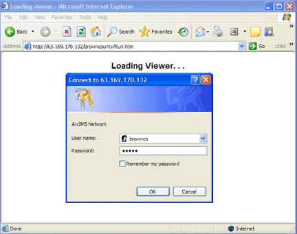
Figure 2.
Although the Online GIS Is
Password-Protected, Access Is Freely Available to Anyone Willing to
Receive Training from K-State Research and Extension of Brown County.
Summary
There are many benefits to a collaborative online GIS system. The biggest benefit is that GIS datasets can be easily shared by all county departments, resulting in huge savings to taxpayers. Because the GIS system is accessed with a Web browser, it is not necessary to purchase individual GIS programs, resulting in even greater savings. This means operating systems such as Linux and Macintosh will also be supported.
Possibly overshadowing the benefit realized by Brown County government are the benefits impacting the public. Taxpayers have access to the same information that local officials use to make decisions. This increases the public's ability to participate in local decision-making and improves access to the democratic process.
Perhaps most exciting are the potential educational impacts of the system. An online system means educational groups, such as schools or 4-H programs, can augment their curricula with local spatial explorations.
References
Milla, K. A., Lorenzo, A. & Brown, C. (2005). GIS, GPS, and remote sensing technologies in Extension Services: Where to start, what to know. Journal of Extension, [On-line] 43(3) Article 3FEA6. Available at: http://www.joe.org/joe/2005june/a6.shtml
Purcell, A. D., Ponomarenko, A. L., & Brown, S. C. (2006). A fifth grader's guide to the world. Science & Children, July.
Stuver, K. S. (2002). A GIS database and Web application feasibility study for the City of San Antonio Environmental Services Department (unpublished thesis), Department of Earth and Environmental Science, University of Texas at San Antonio.