October 2007 // Volume 45 // Number 5 // Ideas at Work // 5IAW3
Land Use and Health: What Role for Extension?
Abstract
Research has begun to relate adverse health outcomes to the way communities are designed and built. One challenge is determining how to reintegrate health into planning and development processes. The article presents an overview of a community-university partnership known as the Capital Area Land Use and Health Resource Team, located in Michigan's tri-county region. The article argues that Extension agents are well placed to bridge the gap between planning and public health. Agents can facilitate greater community understanding of the relationship between land use and health, and help improve land use decision-making to create environments that support healthier lifestyles.
Introduction
An emerging body of research has begun to relate adverse health outcomes to the way we design and build our communities (e.g., Frumkin, 2003; Jackson, 2003). Most prominently, urban sprawl has been correlated with lower levels of physical activity, higher levels of obesity, and the increased prevalence of chronic diseases (e.g., Ewing, Schmid et al., 2003). Less publicized land use and health connections include increased levels of asthma due to deteriorating air quality, increased exposure to waterborne pathogens due to impacted surface waters, and the markedly worse health status of central city residents associated with concentrated poverty (Young, Miller et al., 1998; Frumkin, 2002).
One challenge is determining how to integrate health concerns into planning and development processes (Corburn, 2004). The public health and urban planning literatures have identified ways to bridge this gap. Public health practitioners want public health involved in land use decision-making processes, including scrutinizing the health impacts of projects and policies (Northridge & Sclar, 2003). Public health practitioners also see opportunities for changing land use regulations to take health into account, for instance in the siting of fast food restaurants (Ashe, Jernigan et al., 2003). Planners see potential for addressing health through transportation planning by building communities supportive of walking and bicycling (Handy, Boarnet et al., 2002).
One potential resource that has not been discussed is Extension. Altering development patterns, facilitating transportation options, and broadening understanding of land use impacts are not technocratic exercises. Progress on such issues requires community-based education, on-going technical assistance in land use and design, and inter-agency and inter-community cooperation that have long been the realm of Extension. This article presents an overview of a multi-agency collaboration occurring in the tri-county region encompassing Lansing, Michigan.
The Land Use and Health Resource Team
Begun in 2003, the Land Use and Health Resource Team (LUHRT) is comprised of persons from Michigan State University (MSU) Extension, the Ingham and Clinton County Public Health Departments, Tri-County Regional Planning Commission, MSU researchers, planning agencies, environmental organizations, pedestrian/bicycle advocates, and developers. The LUHRT formed with the goal of integrating health into local planning and decision-making. To do so, the LUHRT has a four-pronged strategy: 1) communication, 2) applied research, 3) outreach/education, and 4) technical assistance.
The communication strategy is simple: participants hold monthly meetings hosted by a health department and chaired by the director of the regional planning commission. Initial meetings were information exchanges; they have evolved into work planning sessions with specific tasks and outputs.
The second strategy has been to conduct applied research to better understand local land use and health relationships. Health data on physical activity, safety, early death, and air and water quality were brought together with GIS-based land use data to provide a snapshot of land use-health relationships. Findings include lower levels of physical activity in rural areas, pedestrian fatality rates twice the Surgeon General's 2010 target, and higher years of potential life lost (i.e., poorer health) in the Lansing's urban core. An accessible publication was prepared and disseminated (Capital Area Land Use and Health Resource Team, 2005).
Extension's leadership has been critical in formulating education/outreach actions. In early 2006, a half-day conference convening local leaders, planners, developers, and public health was held. The conference disseminated information on the health-land use connection, demonstrated local best practices, and asked participants to identify areas for action. Participants spoke of the need to expose planning commissioners to research findings regarding community design and health, as well the need for accessible and appropriate health data for planning processes. Other concerns such as ensuring access to healthy foods, facilitating compact development to enhance water quality, and remediating brownfields were identified as subjects important to the communities represented.
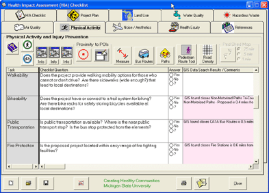
The technical assistance strategy focuses on overcoming information gaps. With assistance from MSU's Center for Remote Sensing and GIS services, the LUHRT has developed a GIS-based tool to assist planners in examining potential health impacts prior to development. The health impacts tool uses a user-friendly and affordable GIS interface known as the "Michigan MapImage Viewer" appropriate to local governments without professional planning staff (Figure 1). The tool is based on a checklist disseminated by the National Association of County and City Health Officials and is intended for use during site plan review, which is when a developer comes before a local planning board. The GIS interface enables officials to evaluate site plans in relation to health objectives such as enhancing physical activity, improving water quality, and ensuring access to grocery stores, recreational facilities, and open space.
Figure 1.
Site Plan Review Tool Interface
The LUHRT: Next Steps
The LUHRT is poised to implement a recently developed action plan for community education/outreach and technical assistance. To accomplish this, university Extension is crucial. Most partners in the LUHRT committee are place-bound--working with their particular county, local government, university department, or constituents. Extension was recognized as the appropriate actor to cross jurisdictions, agencies, and even disciplinary bounds.
A land policy educator with an interest in health and planning has been recruited by Clinton, Eaton, and Ingham counties to work with the regional planning commission and county public health. Community outreach, particularly to planning commissions and leaders, is a priority. The educator is spearheading further work on health impacts, including test applications of the GIS tool. To that end, she has already presented the tool at state and national planning conferences.
Conclusion
Judging from the reception of the LUHRT, land use and health is a subject in which Extension's strengths can be put to good use and its value added proven to a wider audience. Due to its expertise in community mobilization, community-based education, and translating research into practice, Extension is well placed to "bridge the gap" and bring this emerging knowledge-base and innovative practices to increasingly motivated communities.
Take a fundamental first step: call a meeting to initiate dialogue between planners, public health, and local interest groups like walking/biking coalitions, Safe Routes to School committees, neighborhood associations, gardening groups, etc. If the Michigan experience is representative, the response will be positive, and Extension's leadership will be more than welcome.
References
Ashe, M., Jernigan, D. et al. (2003). Land use planning and the control of alcohol, tobacco, firearms and fast food restaurants. American Journal of Public Health 93(9): 1404-1408.
Capital Area Land Use and Health Resource Team (2005). Our environment, our health: Capital Area Land Use and Health Resource Team regional update. Lansing, MI, Ingham County Health Department.
Corburn, J. (2004). Confronting the challenges in reconnecting urban planning and public health. American Journal of Public Health 94(4): 541-545.
Ewing, R., Schmid, T. L. et al. (2003). Relationship between urban sprawl and physical activity, obesity and morbidity. American Journal of Health Promotion 18(1): 47-57.
Frumkin, H. (2002). Urban sprawl and public health. Public Health Reports 117: 201-217.
Frumkin, H. (2003). Healthy places: Exploring the evidence. American Journal of Public Health 93(9): 1451-1456.
Handy, S. L., Boarnet, M. G. et al. (2002). How the built environment affects physical activity: Views from urban planning. American Journal of Preventive Medicine 23(2S): 64-73.
Jackson, R. J. (2003). The impact of the built environment on health: An emerging field. American Journal of Public Health 93(9): 1382-1384.
Northridge, M. E., & Sclar, E. (2003). A joint urban planning and public health framework: Contributions to health impact assessment. American Journal of Public Health 93(1): 118-121.
Young, D. R., Miller, K. et al. (1998). Physical activity patterns of urban African Americans. Journal of Community Health 23(2): 99.