June 2007 // Volume 45 // Number 3 // Research in Brief // 3RIB5
Evaluating Extension Efforts Along Lake Ontario's Eastern Shore
Abstract
The Eastern Lake Ontario Dune and Wetland Area (ELODWA) is a 17-mile stretch of sand dunes, wetlands, and shoreline on the eastern coast of Lake Ontario in New York State. High visitor use of this fragile ecosystem has led to significant erosion of its dunes in the past. This article describes the multi-faceted Extension efforts that have been implemented in the ELODWA over the past two decades to reduce negative visitor impacts, and how these efforts have been evaluated. Results indicate that Extension efforts have been effective at reducing negative visitor impacts throughout most of the dune ecosystem.
Introduction
The Eastern Lake Ontario Dune and Wetland Area (ELODWA), a 17-mile stretch of Lake Ontario coastline, is the only freshwater dune ecosystem in New York State (Figure 1). The unique wetlands and sand dunes of the area are home to several endangered species, including the black tern (Chlidonias niger surinamensis) and bog buckmoth (Hemileuca sp.). Residents and visitors use the ELODWA's seven public and organization-owned properties for recreational activities such as swimming, hiking, birdwatching, and boating (Figure 2).
Figure 1
The Eastern Lake Ontario Dune
and Wetland Area Is Located in Northern New York State
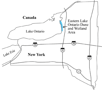
Figure 2
The Eastern Lake Ontario Dune
and Wetland Area Includes Seven Properties Open to the Public

High visitor use, however, has led to erosion of the sand dunes as well as wetland degradation. The need for visitor management and education, combined with the diversity of ELODWA landowners (i.e., private property owners, the New York State Department of Environmental Conservation (NYSDEC), New York State Office of Parks, Recreation and Historic Preservation (OPRHP), and The Nature Conservancy (TNC)), make Extension efforts necessary at the governmental, organizational, and private levels.
This article discusses the implementation and evaluation of NY Sea Grant's Extension efforts in the ELODWA over the past 20 years. Because of the diversity of Extension efforts made, three mechanisms for program evaluation were used: a visitor survey, a visitor use monitoring study, and photographic monitoring. The objectives for each of these techniques are discussed in the "Evaluating Management Efforts in the ELODWA" section.
History of Extension Efforts in the ELODWA
Twenty years ago, dune erosion in the ELODWA became a concern of public land managers and local residents. Informal trails were created across the dunes as visitors trampled and consequently killed the beachgrass holding the sand in place. Trails devoid of vegetation quickly became large "blowouts" as the strong winds off Lake Ontario gouged holes through the dunes. Sand was blown inland into the wetlands once sheltered by the dunes, affecting wildlife habitat.
In response to this extensive erosion, NY Sea Grant Extension staff coordinated the formation of The Ontario Dune Coalition (TODC), an informal coalition of stakeholders (i.e., land managers working for the NYSDEC, OPRHP, and TNC; representatives of homeowner associations; county planning board and soil and water conservation district staff; and NY Sea Grant Extension specialists) dedicated to protecting the dune ecosystem through visitor management.
In 1988, through TODC's efforts, a wooden dune walkover structure (similar to a boardwalk) was constructed in the Lakeview Marsh Wildlife Management Area at the site of a large blowout, enabling visitors to cross the dune without causing further harm. In other blowout areas, volunteers restored vegetation by planting nursery-grown beachgrass. Snowfencing was installed to block visitor entrance to blowouts and trap blowing sand. Within several years, the effectiveness of these initial management strategies at reducing dune erosion became noticeable, and additional dune walkovers were built on other major visitor travel paths. One problem, however, remained--visitors were still walking into the dunes, creating new blowouts in recently re-vegetated areas. TODC realized that a strong educational effort was needed.
In 1994, New York Sea Grant and the SUNY College of Environmental Science and Forestry (SUNY-ESF) created an interpretive plan for the ELODWA (Earnest, 1994). The plan included a theme that was used to unify educational efforts within the area: "With a little understanding and care, the sand dunes and wetlands of eastern Lake Ontario can be preserved for both wildlife and people." Locations for interpretive kiosks and signs, and the development of an interpretive guidebook were recommended. The guidebook was printed 1 year later and distributed to ELODWA visitors. Sea Grant Extension staff also designed two types of signs for the area: parking area kiosks interpreting the importance of staying off the dunes, and small interpretive signs, 12 x 12 inches in size, placed along the beach to discourage visitor entry into the dunes.
At the same time, a dune steward program, staffed by student interns, was created by NY Sea Grant in cooperation with TNC, OPRHP, and NYSDEC. The stewards educate visitors about the dune ecosystem and erosion, monitor the number of visitors entering each property, post interpretive signs where needed, and install "string fencing" (i.e., string mounted on posts that encourages visitors to stay out of the dunes) to channel visitor travel. Stewards are trained and supervised by NY Sea Grant Extension staff annually.
Evaluating Management Efforts in the ELODWA
While Extension efforts were thought to contribute to the reestablishment of dunes observed throughout the ELODWA by property managers, a thorough evaluation of the Extension program used in the ELODWA was needed to verify observations. Three evaluation techniques were used by Extension staff: visitor surveys, visitor use monitoring, and photographic monitoring.
Visitor Surveys
Short surveys of visitors were conducted in the summers of 1997, 2003, and 2004 to identify the impact of Extension efforts in the ELODWA on visitors' perceived behaviors and to collect demographic data about visitors (Kuehn, 1998; Thompson, 2005). In 1997, 93 beach users were randomly surveyed on public properties within the ELODWA; in 2003 and 2004, 359 beach users were surveyed (data collected in 2003 and 2004 were combined for analysis). Dune stewards randomly surveyed visitors between 11 AM and 5 PM from Memorial Day through Labor Day. Most survey questions remained unchanged between 1997 and 2003/2004 for comparison purposes. Survey data were analyzed using descriptive statistics.
Visitor Use Monitoring
In 2003, SUNY-ESF and NY Sea Grant initiated a monitoring study in the ELODWA. The objectives were to identify summertime visitor use patterns and trends in shoreline areas; identify correlations between daily visitor numbers and numbers of violations (e.g., walking into the dunes, having an unleashed dog, littering); and identify a data collection protocol for future monitoring efforts.
Data collected from 1988 to 1990 and 1995 to 2002 were first assessed by researchers. Inconsistencies were identified in data collection methodologies for 1988 through 1999; data from these years were not used for further analysis. Next, an indirect count method (Watson, Cole, Turner, & Reynolds, 2000) was selected for estimating past and current visitor use in five of the ELODWA properties; entrance booth attendance numbers were collected for the two state parks instead.
The indirect count method uses regression equations to estimate total visitor use from other independent measures--in this case, "spot counts" (i.e., counts of visitors made from pre-determined observation points during a 5-minute time interval at a specified time of day), weather data, and day of the week (i.e., weekday vs. weekend day). To calculate the regression equations, however, both total and spot count data were needed for the same randomly-chosen days.
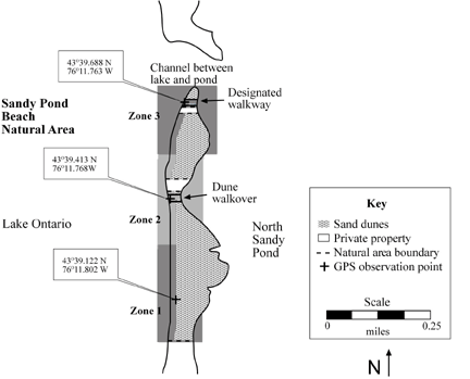
In the summer of 2003, one weekend day and one weekday were randomly chosen during 8 weeks as "full count/spot count" days. Use zones were delineated in the five properties using visitor access patterns observed in previous years and the location of existing spot count observation points (Figure 3). Data were collected on full count/spot count days in each use zone. Beach users within 250 feet of observation points were included in spot counts. Full counts of zones were conducted using a beach sweep method (i.e., dune stewards traversed the beach from one end of each zone to the other, counting visitors as they walked).
Figure 3
Three Visitor Use Zones Were
Identified in the Sandy Pond Beach Natural Area
Regression equations were calculated for each zone in 2003 using SPSS and then used to estimate the number of visitors per day for each zone; zone estimates were totaled to calculate the total summertime use per property. Following minor modifications, the process was repeated in 2004; new regression equations were calculated; and total annual use for 2000 through 2004 was estimated.
Photographic Monitoring
Photographs were taken of 35 sites throughout five ELODWA properties on an annual basis between 1997 and 2005 by TNC and NY Sea Grant. (Monitoring at some sites did not begin until 2000.) The objective was to identify changes over time in the vegetative cover and profile of dunes that had experienced blowouts and/or vegetation loss. Visual comparisons were made between photos taken from the same vantage points; changes in dune height and vegetative cover were rated on a five-point scale from 0 to 4 (0 = no change; 4 = complete vegetative cover plus increased dune height).
Results of Evaluation Techniques
Visitor Survey
Demographic results from the 2003/2004 survey indicate that many ELODWA users are repeat visitors and visit more than 10 times per year. Ninety-three percent of respondents were from New York; some were tourists, while others were local residents. Most visited with their family (44% in 2003/2004), friends (23%), or both friends and family (23%) and heard about the ELODWA from a friend or relative. Sixty-eight percent of respondents were between the ages of 20 and 59. On average, respondents spent about 5 hours per visit. The most popular activities were walking and swimming. Many respondents used one of the dune walkovers (77%) or designated trails (40%) during their visit; other facilities such as boat launches and observation towers were used to a lesser extent (Thompson, 2005).
In order to identify if the interpretive message of "stay off the dunes to prevent dune erosion" was actually reaching visitors, several open-ended questions were included on the questionnaire. As indicated by visitor responses, a large majority (78% of the respondents in 2003/2004 and 94% in 1997) understood that beach grass and other vegetation stabilize the dunes and prevent sand erosion. Most visitors (93% in 2003/2004 and 98% in 1997) gave at least one correct answer when asked to identify two visitor actions that cause dune erosion (Thompson, 2005; Kuehn, 1998).
Visitors were asked to identify the types of educational information they used during their visit. Twenty-eight percent used interpretive signs installed on walkovers, 19% used kiosks, and 8% used the guidebook. In addition, a large majority of respondents (91% in 2003/2004 and 98% in 1997) indicated that they had seen the small interpretive signs along the beaches. Ninety-three percent in 2003/2004 (94% in 1997) indicated that the signs were effective in encouraging them to stay out of the dunes. Most visitors (83% in 2003/2004) approved of having these signs along the beach; 16% of visitors had no opinion about the signs; and less than 1% indicated that the signs detracted from the natural landscape (Thompson, 2005).
Visitor Use Monitoring
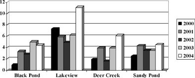
Between 2000 and 2004, public shoreline areas within the ELODWA attracted an estimated average of 142,194 visitors annually between Memorial Day and Labor Day (Kuehn & Habig, 2005). During this 5-year period, visitor use was at its highest in 2001, when an estimated 162,227 users visited (Figure 4). Levels of use were lowest on most properties in 2003 and 2004, likely due to cooler-than-normal daytime temperatures (as indicated by regression analysis). Visitor use was highest near major access points (e.g., walkovers and boat anchoring locations). Correlations between the daily number of visitor violations observed and the estimated daily number of visitors revealed no significant relationships for the four public properties studied (Figure 5). The variability of annual mean violations was generally low (standard errors ranged from 0.20 in Dear Creek in 2002 to 1.57 in Lakeview in 2004).
Figure 4
Total Estimated Daytime Visitor
Use in the ELODWA Is Shown for the Summers of 2000 Through 2004
(Kuehn & Habig, 2005)
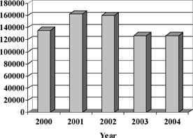
Figure 5
The Average Daily Number of
Violations Observed Is Shown for Four ELODWA Properties During the
Summers of 2000 Through 2004 (Kuehn & Habig, 2005)
Photographic Monitoring
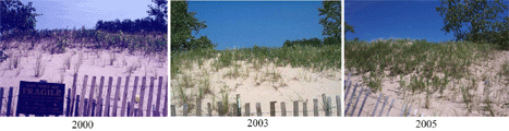
Moderate (scaled rating of 2) to high (rating of 4) dune restoration was identified on 74% of the sites studied; 9% of the sites had a slight increase in vegetation, and 17% had no noticeable change. Figure 6 shows the high success of dune restoration efforts at Sandy Pond Beach Natural Area, once one of the most highly disturbed areas in the ELODWA. In 1997, the boardwalk in this natural area was exposed; by 2005, the height of the dune had increased, covering the boardwalk, and string fencing was installed. Figure 7 shows the moderate success of dune re-vegetation efforts in Black Pond WMA over a shorter period of time (i.e., 2000 to 2005).
Figure 6
The Photos Above Show the
Re-establishment of a Sand Dune in Sandy Pond Beach Natural Area
Between 1997 and 2005 (Photos Courtesy of TNC and New York Sea Grant;
NY Sea Grant, 2005)
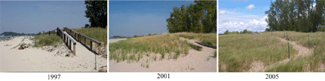
Figure 7
The Photos Illustrate the Re-Establishment of
Dune Vegetation in the Black Pond WMA Between 2000 and 2005 (Photos
Courtesy of TNC and New York Sea Grant; NY Sea Grant, 2005.)
Implications for Extension
Results from the visitor survey and photographic monitoring reveal that Extension efforts appear to have reduced visitor behaviors that lead to dune erosion in the ELDOWA. For example, photographic monitoring techniques show moderate to high re-growth of vegetation on most sites, indicating a change in visitor behaviors. Survey responses indicate that the interpretive message of "prevent dune erosion by staying off the dunes" is being effectively communicated to visitors. However, while the majority of visitors surveyed appear to be positively influenced by Extension efforts, a small percentage of visitors appear to be resistant to altering their behaviors; enhanced Extension efforts may be needed to reach these visitors.
Results from visitor use monitoring provide insight into visitor access patterns and use trends--information necessary for planning future Extension efforts. Monitoring also reveals that the average daily number of violations does not appear to be linked to the number of visitors using an area. Violations appear to be occurring to a greater extent in areas that are large and, consequently, difficult to monitor (e.g., Lakeview Marsh). Extension efforts may need to focus more on difficult-to-reach locations within the ELODWA in the future. Additional monitoring is needed to determine the extent of violations occurring when stewards are off-duty (e.g., evenings); Extension efforts may be needed during alternate times of day as well.
The ELODWA program comprises a diversity of Extension efforts that focus on both visitors and the dune ecosystem. This diversity has made it necessary to implement an equally diverse evaluation strategy that utilizes visitor surveys, visitor use monitoring, and photographic monitoring. This three-pronged strategy has helped Extension specialists assess past program efforts, modify and enhance current program components, and obtain information for planning future efforts. Long-term monitoring has revealed changes in the ELODWA that might not have been apparent through short-term monitoring alone (e.g., increases in dune vegetative cover and height). Although the study was implemented in a natural setting, the idea of using evaluation techniques that are as diverse and long-term as the programs being evaluated is transferable to many other Extension-related settings as well.
Acknowledgements
The authors wish to thank David White, NY Sea Grant, and Sandra Bonanno, formerly of The Nature Conservancy and NY Sea Grant, for setting the foundation for this study with their educational efforts in the Eastern Lake Ontario Dune and Wetland Area. We also wish to thank the anonymous Journal of Extension reviewers for their comments.
References
Earnest, G. (1994). Interpretive recommendations for the Eastern Lake Ontario Sand Dune and Wetland Area. Oswego, NY: NY Sea Grant. Available at: http://www.nysgextension.org/glhabitat/dune/documents/interprecs.pdf
Kuehn, D., & Habig, R. (2005). Monitoring recreational use in the Eastern Lake Ontario Dune and Wetland Area. Syracuse, NY: SUNY College of Environmental Science and Forestry.
Kuehn, D. (1998). Results of the 1997 Eastern Lake Ontario Dune and Wetland Area interpretive program evaluation. Oswego, NY: NY Sea Grant. Available at: http://www.nysgextension.org/tourism/tourism/duneevalreport.html
Thompson, M. (2005). Eastern Lake Ontario beach user survey - 2003/2004. Oswego, NY: NY Sea Grant.
Watson, A., Cole, D. N., Turner, D. L., & Reynolds, P. S. (2000). Wilderness recreation use estimation: A handbook of methods and systems. General Technical Report RMRS-GTR-56. Ogden, UT: USDA Forest Service.
NY Sea Grant. (2005). Eastern Lake Ontario Dunes photomonitoring project. Retrieved February 17, 2006 from: http://www.nysgextension.org/photomonitoring/monitoringhome.htm