June 2007 // Volume 45 // Number 3 // Feature Articles // 3FEA6
The New York City Watershed Model Forests Revisited Five Years Later: An Assessment of Successes, Failures, and Challenges for the Future
Abstract
The New York City Watershed Model Forests were established to demonstrate that working forested landscapes can be compatible with water quality. The Model Forests were designed to integrate education, research, and demonstration to a wide audience. Two of the four Model Forests are successful, serving the outreach and continuing education needs of forest stewards in the watershed. The other two Model Forests have confronted challenges stemming from the negative public perception of forest management. Explanations on successes and shortcomings, coupled with a survey analysis of model forest users, provide insight into the project's progression over the last 7 years.
Introduction
In 2001, the Journal of Extension published an article, "Developing the New York City Watershed Model Forests: Working Laboratories to Study and Demonstrate Sustainable Forestry," which described ambitious plans for four Model Forests within the New York City (NYC) watershed located in the Catskill and lower Hudson Valley regions of New York State (Germain, Shwartz, & Parrish, 2001). Six years later, an update on our experiences is merited as we continue to promote sustainable forestry in this important watershed.
This article provides Extension practitioners with an update on how the Watershed Agricultural Council's (WAC) Forestry Program, administrator of the Model Forests, is progressing toward its goal of implementing the four Model Forests. First, we provide the context for the Model Forest Program and review procedures for establishing a Model Forest site; second, we summarize the status of each Model Forest, beginning with our successes, followed by a summary of our shortcomings and on-going challenges. We conclude by reporting the results of a formative evaluation of the Model Forest Program. We hope our experiences will be instructive to forestry Extension professionals, as well as Extension agents in general, currently implementing or considering similar long-term demonstration sites.
The Context
New York City's water supply system (Figure 1) is the largest unfiltered surface storage and supply system in the country. The entire system supplies drinking water to 9 million people in the greater NYC area, plus another one million tourists and commuters. The Catskill/Delaware system west of the Hudson River comprises nearly 1,625-square-miles and supplies approximately 90% of the city's water.
Figure 1.
New York City Water Supply
System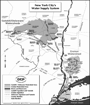
Forests cover approximately 90% of the Catskill/Delaware system (Heisig, 2000; EPA, 2001; Anderson, Hardy, Roach, & Witmer, 2001). An estimated 73% of the forest area within the Catskill/Delaware system is controlled by nonindustrial private forestland (NIPF) owners. These working forests are considered a preferred open space land use for water quality protection (Watershed Forest Task Force, 1996; NYC DEP, 2002). The working landscape is what distinguishes the Catskill/Delaware watersheds from other surface water supply watersheds in the country.
Surface water is used by other large cities in the U.S., such as Seattle, San Francisco, Boston, and Portland. However, these cities own the majority of their water supply lands, whereas NYC owns only 10% of its watershed. Consequently, the Watershed's NIPF owners, which include approximately 350 farmers with forestland, play a vital role in maintaining a high quality water supply. NIPF owners, as well as the foresters and loggers who implement forest management activities, hold the key to maintaining water quality. Using demonstration sites to model sustainable forestry to this critical audience is the foundation for Extension activities in the Watershed.
The Model Forest Program
Planning for four Model Forests began in the fall of 1997. During the next 2 years, the following four sites in New York State were selected as forest demonstration areas designed to integrate research, continuing education for foresters and loggers, and public outreach:
- Lennox Memorial Forest (85 acres), owned by Delaware County and managed by Cornell Cooperative Extension, located in the Cannonsville Reservoir watershed;
- Frost Valley YMCA Model Forest (290 acres), owned and managed by the Frost Valley YMCA, located in the Neversink Reservoir watershed;
- Mink Hollow Model Forest (220 acres), owned and managed by the NYC Department of Environmental Protection (DEP), located in the Ashokan Reservoir watershed; and
- Nimham Mountain Model Forest (130 acres), owned by New York State (NYS) and managed by the NYS Department of Environmental Conservation (DEC), located in the West Branch Reservoir watershed.
The NYC Watershed Model Forests demonstrate management practices that strike a balance between working forests and water quality while offering a practical means for studying and monitoring the relationships between ecosystem functions and water quality. In short, they are both outdoor classrooms and laboratories. As depicted in Figure 2, the Model Forest process is circular, providing venues for science and Extension, while mandating that new questions and ideas from various target audiences be used to direct these efforts.
Figure 2.
The Relationship of Model Forest
Activities to the Participating Institutions and the Outreach and
Extension Audiences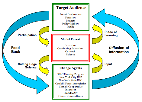
The WAC Forestry Program has built outreach and educational programs that rely on the ability of the Model Forests to provide a location to effectively demonstrate the complex issues confronting forest management. Organizations representing foresters, loggers, and landowners use the Model Forests to conduct training sessions in topics such as silviculture, ecology, forest operations, Best Management Practices, and riparian management. Groups of students from New York City schools who participate in the Watershed Bus Tour Program routinely visit the forests to learn about their connection to the upstate watershed. The Watershed Forestry Institute for Teachers uses the Model Forests to learn the basics about forest management and water quality. Upon completing the 1-week Institute, the teachers return to their respective schools and participate in the Green Connections Program, which seeks to partner watershed classrooms with classes from city schools. The students work cooperatively on projects throughout the year, with their efforts culminating in a visit to the watershed and the Model Forests.
Model Forest Design
For the purposes of research, continuing education, Extension, and outreach, each Model Forest was delineated into a series of experimental treatments that demonstrate various forest management activities. The location and size of treatment compartments was determined through the use of forest cover type maps, topographic maps, aerial photos, and inventory plots. The treatment compartments range in acreage depending upon the size of the Model Forest, forest cover types, and research needs. For instance, in cases where water quality research is the primary focus, the compartments followed the boundaries of a defined headwater catchment. A continuous forest inventory (CFI) system was completed on each Model Forest. The CFI system provides important baseline data to monitor manmade and natural changes in the conditions of a forest (Germain et al., 2001).
Lennox Memorial Model Forest
The Lennox Memorial Model Forest, an 85-acre demonstration area (Figure 3), was delineated into 14 experimental compartments ranging in size from three to seven acres. Approximately 170 CFI plots were completed in 1998. We generated silvicultural prescriptions for each compartment and completed harvesting activities in 1999. Following the harvest, we re-measured the CFI plots, providing the basis for the signs and educational scripts. By 2000, we installed signs throughout the demonstration area highlighting silvicultural prescriptions and Best Management Practices (BMPs). Roads constructed during the harvest offer several opportunities to demonstrate BMPs. In 2004, 360-degree photo points were established in the center of each compartment. These photo points, taken during the summer and winter, will be used in conjunction with the CFI plot data to provide a visual baseline for monitoring long-term forest conditions.
Figure 3.
The Lennox Model Forest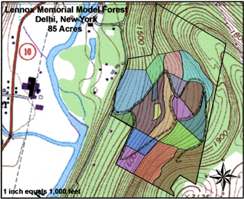
Research on the site has focused on the relationships among various silvicultural cutting regimes, forest regeneration and herbaceous cover. Deer exclosures within three blocks are allowing researchers to monitor the impact of deer herbivory on regeneration and herbaceous plants. In July 2003, an unusual violent wind event altered some of the forest stand dynamics, forcing us to implement salvage cuts in a few of the compartments. Although this natural disaster did have an impact on our silvicultural prescriptions, we incorporated the effects of the storm into our signage and educational scripts.
Overall, this Model Forest has been a huge success, serving as host site for numerous workshops for landowners, foresters and loggers. It is also a popular stop for legislative and public outreach tours.
Frost Valley YMCA Model Forest
The Frost Valley YMCA Model Forest--a 290-acre demonstration area--was delineated into 18 experimental compartments ranging from 8 to 47 acres (Figure 4). Pre-existing U.S. Geological Survey (USGS) experimental units were later added to increase the area to 425 acres. Today, the network of established CFI plots is approaching 900. By 2003, Frost Valley installed signs along the Model Forest road throughout the northern section of the site highlighting silvicultural prescriptions and BMPs installed on the road. In 2004, 360-degree photo points were established in the center of each compartment. These photo points will be used in conjunction with those taken at the Lennox Memorial Model Forest. To date, seven compartments have been harvested.
Figure 4.
The Frost Valley YMCA Model
Forest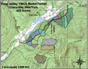
The partnerships among State University of New York - College of Environmental Science and Forestry (SUNY-ESF), New York City DEP, USGS, WAC Forestry Program, and the Frost Valley YMCA form the basis for a strong research program examining the effects of forest management and silvicultural prescriptions on stream water chemistry and stream biota. Five experimental compartments are delineated based on watershed boundaries and equipped with V-notch weirs and water quality monitoring equipment. The data allows researchers to examine the effects of various harvesting levels (basal area removal) on nutrient fluxes--particularly nitrogen--from these headwater streams. The same streams are monitored to determine the effects of forest management on stream biota, using aquatic macroinvertebrates as the biotic indicators. In addition to water quality research, we are monitoring the relationships among the various silvicultural cutting regimes, forest regeneration and herbaceous cover.
The Frost Valley Model Forest is used extensively by the YMCA as part of their environmental science curriculum to 30,000 students annually. Each summer, the WAC Forestry Program hosts a forestry field day for landowners, loggers, and foresters. In 2005, the WAC Forestry Program launched a virtual tour of the forest on its Web site <http://www.nycwatershed.org/>. The tour invites visitors to become familiar with the various components of the Model Forests prior to visits and is a key component of many middle and high school curricula for those studying watersheds and forestry. Thus far, the Frost Valley YMCA Model Forest represents our greatest success story in terms of truly integrating research, Extension, and outreach.
Nimham Mountain Model Forest
This 130-acre demonstration site is located within the 1,023-acre Nimham Mountain State Multiple Use Area managed by NYS DEC in the lower Hudson Valley. The forest was initially divided into 8 forest stands ranging from 7 to 75 acres. 300 CFI plots were completed in 2000. Thereafter, researchers identified an 85-acre watershed within the 130-acre demonstration area to conduct water quality research. Under the direction of the USGS, researchers installed a v-notch weir and a sampling system in October 2001.
In October 2003, the NYS DEC organized a public forum to introduce the Nimham Mountain Model Forest project to the local community. Regional DEC representatives, the WAC Forestry Program, and researchers from SUNY-ESF presented various aspects of the Model Forest project during the meeting. The project was met with numerous questions from local residents. Chief among these questions was the perceived lack of communication and public involvement in the initial planning phase of the project. There was general opposition to cutting trees in what many thought of as a state park as well as concerns regarding cultural resources, aesthetics, and water quality impacts. However, it is noteworthy to report that no one was opposed to the concept of a Model Forest; they merely expressed concern in having one "in their backyard." Concerns and suggestions from the public forum were incorporated into a revised Model Forest Plan for Nimham Mountain. To date the efforts to engage the local community and move the Nimham project forward are awaiting the consent of the NYS DEC.
Given its proximity to New York City, the Nimham Mountain Model Forest is intended to serve as an outlet for education and research at the crossroads of rapid development and land conversion. We visualize this site as a mechanism for reconnecting urban and suburban populations with the concept of a working forested landscape
Mink Hollow Model Forest
This 220-acre Model Forest is owned by New York City and managed by NYC DEP. It was delineated into 18 experimental compartments ranging from 7 to 75 acres. Nearly 500 CFI plots were completed by 2002.
In light of the difficulties confronted in the implementation of the Nimham Mountain Model Forest project, the partnering organizations decided to postpone the Mink Hollow project. Because the resources to support the outreach efforts necessary to integrate community concerns into each Model Forest are limited, it was decided that the Nimham project would be addressed first. The future of Mink Hollow Model Forest project will hinge on the lessons learned from the Nimham Mountain Model Forest effort.
Building on Positive Achievements
It is critical that we build on the success of the Frost Valley and Lennox Model Forests while learning from the setbacks encountered with the Nimham Mountain and Mink Hollow projects. We developed and administered a formative evaluation designed to measure the efficacy of the two operating Model Forests.
In 2005, the WAC Forestry Program and SUNY-ESF conducted an evaluation of the Model Forest program by surveying 62 users (from an original sample of 104 individuals). The population consisted of registered users from two active Model Forest sites (Lennox and Frost Valley). The responses are based on seven workshops offered over the past 3 years. A set of demographic questions and open-ended questions were administered. The open-ended questions asked respondents to comment on 1) if they plan to attend another Model Forest in the future and why or why not and 2) what topics they would like addressed in the future.
The survey also included three summated scales designed to measure 1) Quality of Experience, 2) Quality of Learning, and 3) Impact on Perspective. Summated rating scales combine several indicators to measure a broader latent concept that is assumed to have an underlying quantitative measurement continuum (DeVeillis, 1991). The "quality of experience" scale consisted of statements associated with the quality of the facilities, layout, design, event, and presenters. The "quality of learning" scale focused on statements measuring the Model Forests as effective learning venues. The "impact on perspective" scale consisted of statements measuring the effectiveness of the Model Forests to convey the message that a working landscape is compatible with water quality.
Responses to the statements in the summated scales were based on 6-point scales. A "1" indicated strongly disagree and "6" strongly agree. Points "2" and "5" represented disagree and agree, while "3" and "4" represented mild disagreement or agreement. The validity of the survey instrument was assessed through expert review on two different draft surveys. The reliability of all scales was evaluated by measuring Cronbach's alpha coefficient for each scale. Reliability measures the survey instrument's ability to convey the same meaning to the entire sample population, also referred to as the internal consistency of the instrument.
The respondents were primarily male (84%) forestland owners (60%) with a wide distribution of ages. The remaining respondents were equally split between forestry practitioners and interested citizens. Nearly two-thirds of the respondents had only participated in one event; one-fifth had attended two; and the remaining ranged from three to seven events. In terms of location, there was an even split between the Lennox Memorial and Frost Valley Model Forests among attendees.
Over 95% of the respondents stated that they would attend another Model Forest event in the future. When asked why, some emphasized the excellent education they received, while others noted that the outdoor and applied aspect of the experience was a draw. In general, their desire to learn about forest and water quality management and research seems elevated rather than diminished by their participation in a Model Forest event. In terms of preferred subject areas, respondents are seeking information in topics such as forestry BMPs and silviculture, as well as wildlife, forest ecology, agro-forestry, GPS use, forest measurements, and private forest economics and policy.
With respect to the three scales (quality of experience, quality of learning, impact on perspective), the two active Model Forests are succeeding in providing a high quality experience (mean = 5.2) and venue for learning (mean = 5.2) for all three respondent categories. The forestland owners and interested citizens also agree that the Model Forests successfully convey the message that a working forested landscape is compatible with water quality (mean = 5.3). The forestry practitioners scored a bit lower on this scale (mean = 4.6) because they are integral and well-seasoned players in the working forested landscape. This result is not surprising then because these individuals already possess a high awareness of the relationship between forest management and water quality.
The contribution made by these forests is evident in their regular use, maintenance, and satisfaction of the end users. We are heartened by the quick infusion of these Model Forests into the lexicon and strategy of water supply managers and forest educators.
As evidence that we are indeed building on our successes, during the summer of 2006, we added the 140-acre Siuslaw Model Forest. The property is owned and managed by Cornell Cooperative Extension of Greene County and features the AgroForestry Resources Center, an educational facility and exhibit area, which will enhance Extension opportunities.
Conclusion
The Model Forests offer a unique experience that often creates a productive environment for discussing the environmental challenges that confront our society. Lessons learned through years of scientific study are passed along to the individuals who collectively make large-scale land management decisions on a daily basis. Consistent with the feedback loop depicted in Figure 2, the conveyors of knowledge often leave with a fresh sense of perspective gained by interacting with the individuals who own and manage our natural resources.
In many ways, the challenges confronted by the Model Forest Program reflect the broader trends common to forest management projects across the nation--particularly those on public lands. In the case of the Nimham Mountain and Mink Hollow Model Forests, it was necessary to account for the unique needs of the local communities. Ironically, both sites are at the urban-rural interface, both spatially and culturally, where a Model Forest is most needed to demonstrate the benefits of a working landscape.
The Model Forests will continue to play an important role in promoting forest stewardship in the NYC Watershed. We believe achieving the program's objectives is critical to the management of New York City's water supply system--not only to provide a venue for conducting forest management and water quality education, outreach, and research, but also as a symbol of the commitment by all to the cooperative and grassroots spirit of the Watershed Forestry Program.
For Further Information
Readers wishing to learn more about the New York City Watershed Model Forest Program should contact René Germain, Chair of the Watershed Model Forest Program, at <rhgermai@esf.edu> or Tom Pavlesich, Manager of the Watershed Forestry Program, at <tpavlesich@nycwatershed.org>.
References
Anderson, J. R., Hardy, E. E., Roach, J. T., & Witmer, R. E. (2001). A land use and land cover classification system for use with remote sensor data: A revision of the land use classification system presented in the U.S. Geological Survey Circular 671. Geological Survey Professional Paper - 964. Washington, D.C: U.S. Government Printing Office.
DeVellis, R. F. (1991). Scale development: Theory and applications. Applied Social Research Methods Series Vol. 26. Sage Publications. Newbury Park, CA.
Environmental Protection Agency (2001). A landscape assessment of the Catskill/Delaware watersheds 1975-1998. Retrieved December 2003 from:http://www.epa.gov/nerlesd1/land-sci/ny.htm
Germain, R. H., Shwartz J., & Parrish, J. (2001). The New York City Watershed Model Forests: Working laboratories to study and demonstrate sustainable forestry. Journal of Extension [On-line], 39(2). Available at: http://www.joe.org/joe/2001april/iw2.html
Heisig, P. M. (2000). Effects of residential and agricultural land uses on the chemical quality of baseflow of small streams in the Croton Watershed, Southeastern New York. USGS WRIR 99-4173.
NYC DEP (2006). New York City's Water Supply System. Retrieved October 2006 from:
http://www.ci.nyc.ny.us/html/dep/html/watersup
Watershed Forestry Task Force. (1996). Policy recommendations for the watersheds of New York City's water supply. New York. 11.