August 2007 // Volume 45 // Number 4 // Tools of the Trade // 4TOT7
Converting a SSURGO Soils Database into a Simple Soils Database for Use in Portable Computer and Web-Based GIS Applications
Abstract
The SSURGO soils survey is a very useful tool for people in need of soils information. However, the SSURGO soils database is too large and complex for practical use in a geographic information system (GIS). A simplified version of the database was developed and combined with an array of other landscape data to make county based GIS products that are utilized by both portable computer and web-based applications. This allows for wider distribution of the soils information and the ability to take the data to the field.
Introduction
The SSURGO soils database developed by the USDA Natural Resource Conservation Service (NRCS) has a wealth of information that has been used extensively since the first paper soil survey books were printed. With the development of the digital information format, many county soil survey maps have been converted to digital shape files that can be used by computer driven geographic information systems (GIS). The many tables of data that are related to the soils maps have been placed into a complex database.
The NRCS has provided this information to the public in a compact disk (CD) format and is also available via the Internet at the NRCS Soil Web Survey site. The CD is basically a digital form of the county soil survey books with printable pages. The NRCS Soil Web Survey site is a searchable Web site for delivering all the data in the SSURGO soils database but has no capability of interacting with a GIS.
To provide the SSURGO data to GIS users, NRCS has made the county databases and related shape files available through the Soils Data Mart Web site. In order to retrieve the database information, a Microsoft Access soils database and the spatial and tabular files specific for each county must be downloaded to a local computer and decompressed. Then a data loading program must be run to associate these files to the database. The result is a county-specific database that ranges from 200 to 300 megabytes in size with over 130 tables.
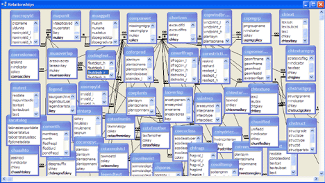
These tables are woven together in a very complex web of relationships. Figure 1 partially illustrates this complex system of tables and relationships. This database provides all of the documentation for the soil survey and contains information in pre-formatted reports. It contains information for a wide variety of users, thus making it difficult to extract only specific information. It suffers the plight of "too much information." The problem with using the SSURGO database in a GIS is that it was designed as a one-size-fits-all. It is too big, complex and cumbersome and does not fit the portable or web-based GIS venues.
Figure 1.
Table Relationships from
Original SSURGO Database Showing Only Some of the Tables and the
Complex Relationships Between Tables
Key Tables and Relationships
Our approach to this problem was to simplify the database to the fewest possible tables with only the pertinent information for our purpose. This resulted in reducing the size of the database to a manageable level, 15 to 30 megabytes as compared to the original database at ten times the size. To do this, we prioritized the information that we wanted to retrieve and studied the schema (framework of the database) in order to understand the relationships between the tables. Only four tables were chosen to include in our abbreviated database as these tables contained the majority of the information that we needed. Figure 2 displays these four tables and the simple relationships between these tables.
Figure 2.
Extracted Tables and
Relationships in the Simplified Database Showing the Four Tables
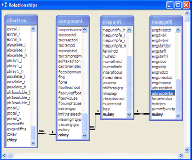
The mapunit and muaggat tables contain the soil series information and have a 1 to 1 relationship, meaning the data in the two tables can be combined. There are one to many relationships between mapunit to component tables and component to chorizon tables. This simply means that there can be many soil components to a soil series and that there can be many soil horizons to a single soil component. These relationships allow a GIS to drill down into the data to retrieve information about a specific location.
Building the New Database
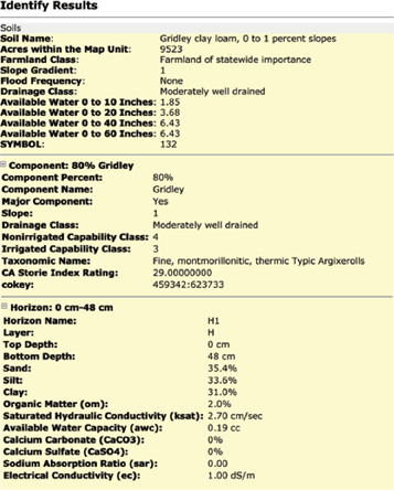
The spatial shape files included in the database are usable directly by the user's GIS but can only be joined to a single table, and there are four tables of information needed. Using the ESRI GIS programs ArcInfo or ArcEditor, the selected tables were imported into a personal geodatabase, and the relationships built between the tables. ArcMap was used to join the map shape file to the soils series table (mapunit) and create a relationship class for the other tables. The result of this effort is visible when the GIS identify tool is used to display table attribute data; the multiple layers of the geodatabase are displayed (called drilling down through the data). Examples of this drill down capability are shown in Figures 3 and 4.
Specific table attribute (column) data can be re-named, calculated, or changed by exporting a table to a Microsoft Excel spreadsheet for manipulation, then importing it back into the database. In our case, we combined the mapunit and muaggat tables into a single table. We also converted some of the attribute values from centimeters to inches because that would be more easily understood by the people using the GIS.
Figure 3.
View of Map and Soils Layer
Drill Down from Web-Based GIS
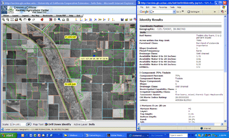
Figure 3.
Detail View of Soils Layer Drill
Down Showing Soil Series, Component, and the Top Horizon Layer
Information
Using the New Database
We built these simplified soils databases for the 17 Central Valley counties of California and developed a GIS for each county. Many map layers were included: soils data, land use, water districts, political boundaries, roads, waterways, township, range, and section information along with historic topography maps and aerial imagery. Data sets were packaged on DVDs because of the large amount of data, in excess of one gigabyte per county. Tutorials and online help are also provided on the DVDs. These data sets allow users of ArcGIS or the free downloadable program ArcReader to use the GIS on a portable computer for field use. This is a powerful feature of this project, especially when the portable computer is equipped with a GPS device.
In order to reach a wider general population audience, who do not have GIS software or the training to use it, we developed a Web-based GIS that a user only needs an Internet connection and browser to use. Our Web-based GIS that incorporates the simple SSURGO database can be viewed at <http://arcims.gis.uckac.edu/SoilsToGo>.
References
Soil Survey Staff, Natural Resources Conservation Service, United States Department of Agriculture. (2005). Soil survey geographic (SSURGO) database for California. Available at: http://soildatamart.nrcs.usda.gov
Soil Survey Staff, Natural Resources Conservation Service, United States Department of Agriculture. (2006) NCSS soil Web survey. Available at: http://websoilsurvey.nrcs.usda.gov/app/