April 2007 // Volume 45 // Number 2 // Research in Brief // 2RIB3
Comparison of Best Management Practice Adoption Between Virginia's Chesapeake Bay Basin and Southern Rivers Watersheds
Abstract
Producers in two regions of Virginia (Chesapeake Bay basin and Southern Rivers region) were surveyed to compare farming practices and agricultural best management practice (BMP) adoption. Objectives were to assess farming operations and determine the extent of cost-share and non-cost-share BMP implementation and gain insight into the impact of selected socioeconomic factors on the BMP adoption. Although farming characteristics and producer attitudes toward pollution and water quality were similar, BMP implementation differed between the two regions. Differences in BMP implementation may be due to a more focused, longer-term NPS pollution control educational effort in the Bay basin.
Introduction
Agricultural nonpoint source (NPS) pollution is a major water quality concern throughout the United States. The 2000 National Water Quality Inventory (USEPA, 2002) reported that runoff from agricultural lands was the leading source of pollution in the impaired rivers and streams assessed. Best management practices (BMPs) are thought to be effective means to reduce NPS pollution (USEPA, 2003a).
Traditionally, agricultural NPS pollution has been addressed by implementing BMPs through an incentive-based, voluntary adoption approach. This voluntary approach has many benefits over a mandatory program, but distinctly contrasts with the regulatory structure of point source controls (Gomez, 1995). The traditional incentive-based approach to resource management appeals to the typical, highly independent farm operator who does not want to be told what he or she should do with privately owned land (Logan, 1990). This approach also allows for flexibility in site-specific characteristics, relies upon the producer's ability to adopt and maintain the practice, and includes no associated enforcement costs. However, with an incentive-based system there can be uncertainty in the consistency and quality of BMPs, conservation plans, monitoring, and adherence to conservation compliance policies (Gomez, 1995).
Agricultural researchers and rural sociologists have repeatedly attempted to understand the factors that influence producers to implement BMPs. Bultena and Hoiberg (1986) state that:
Most researchers believe that producers' lack of awareness of environmental problems in their county or community is not a major factor in their decision not to implement a BMP. Producers do, however, underestimate the severity of their own contribution to environmental problems.
In a survey of approximately 3,200 producers in erosion-prone areas of 13 states, Bultena and Hoiberg (1986) found that 92% of the producers perceived soil erosion as a problem in their home counties, 78% in their local communities, but only 66% on their own farms. Hoban and Wimberley (1992) found similar results in a study of producers that participated in the Rural Clean Water Program and producers that were eligible, but did not participate. Napier, Thraen, and Camboni (1988) concluded that ultimately, if producers adopt a positive attitude towards conservation practices, they will act from self-interest, adopting BMPs they believe will solve perceived problems. This finding suggests that with enough education and resulting voluntary BMP adoption, NPS pollution may be reduced without the need for regulations.
In Virginia, the Department of Conservation and Recreation (VDCR) is charged with administering state agricultural NPS pollution control programs through local Soil and Water Conservation Districts. The VDCR has no regulatory authority but conducts educational programs to increase producer awareness about the potential negative impact of agriculture activities on water quality and on the potential benefits BMPs offer in terms of improved water quality and increased crop production. Funds are systematically allocated to the areas of the state determined to have the most significant agricultural NPS pollution problems. While some cost-share assistance is generally available to producers, the goal of the Virginia's BMP implementation program is to encourage producers to implement additional BMPs on their farms without cost-share assistance (i.e., non-cost-share BMPs).
For several years, concern about the pollution of the Chesapeake Bay has been a high profile issue because it is the nation's largest estuary and a valuable natural resource (CBP, 2004). It supplies millions of kilograms of seafood, functions as a major hub for shipping and commerce, provides habitat for an extensive array of wildlife, and offers a variety of recreational opportunities for residents and visitors. According to the Environmental Protection Agency, the largest anthropogenic contributor of NPS pollution to the Chesapeake Bay is agriculture (EPA, 2003b). Due to the Chesapeake Bay's economic and ecological importance, funds have been allocated to pollution abatement and remediation in the Chesapeake Bay drainage basin. By comparison, substantially less focus and fewer resources have been directed to watersheds in southern Virginia that do not drain into the Bay.
Although information on the extent of BMPs implemented through cost-share programs in Virginia is well documented (VDCR, 2004), very little data are available regarding the extent of non-cost-share BMPs implemented in the state. Developing information on the extent of non-cost-share BMP adoption within the state would enable the VDCR to evaluate the success of its BMP program and modify the program to increase its effectiveness.
The objectives of the investigation reported here were to assess farming operations to determine the extent of implementation of cost-share and non-cost-share BMPs and to gain insight into the impact of selected factors on the adoption of BMPs in Virginia.
Methodology
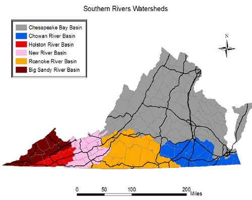
The study was designed to survey producers in two regions of Virginia: (1) 67 counties where >90% of the area in the county drains to the Chesapeake Bay (hereafter referred to as the Bay basin) and (2) producers in 30 counties where ≥ 10% of the area in the county drain away from the Chesapeake Bay (hereafter referred to as Southern Rivers region). The Bay basin contains five river basins (Chesapeake Bay and Small Costal Rivers, James River, Potomac-Shenandoah Rivers, Rappahannock River, and York River basins) (Figure 1a, VDACS, 1992). The Southern Rivers region contains five river basins (Big Sandy River, Chowan River, Holston River, New River, and Roanoke River basins) (Figure 1b).
Figure 1.
Illustration
of River Basins in Virginia's (a) Bay Basin and (b) Southern Rivers
Region
Figure 1a
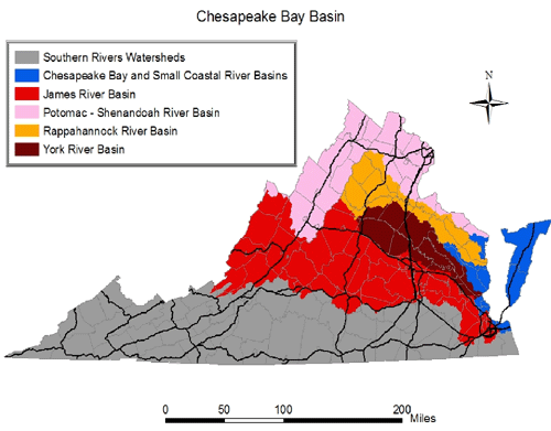
Figure 1b
A survey instrument was developed with input from representatives from the VDCR, the Virginia Farm Bureau, the U.S. Department of Agriculture-Farm Service Agency (USDA-FSA), Virginia Cooperative Extension, and the Center for Survey Research at Virginia Tech. Additionally, experts in hydrology, nonpoint source pollution, sociology, and natural resource economics were consulted. The instrument included 35 questions grouped into four categories: demographic information, farming operation information, producer attitudes related to causes of water pollution, and BMP implementation. The survey was pilot-tested with Virginia Farm Bureau Federation staff from across the state.
Geospatially referenced data and a Geographic Information System (GIS) were used to randomly select producers to receive the survey. Due to the lack of land use data for some counties, the probability that selected locations would not be in an agricultural area increased. Thus, the number of randomly selected sites was increased by a factor of 1.75 to insure the required number of agricultural parcels was surveyed. Maps developed using the GIS data were taken to county USDA Service Centers, where sites were identified from aerial photos and the names of the farm operators corresponding to the randomly selected locations were determined. County tax maps were used to identify property owners when other records were unavailable. Property owner addresses were obtained from courthouse records, were entered into a database, and sorted so that a producer with several farms in one county would not receive multiple copies of the survey.
Some 6,800 surveys were mailed out in the Bay basin and 6,000 in the Southern Rivers region. Three weeks after the survey was mailed, a reminder card urging recipients to complete the survey was mailed. A second survey was mailed two-months after the initial mailing, followed by another reminder card some 4 weeks later.
Results
The information presented here represents a summary of responses from 1,377 producers who farmed some 474,772 acres or 13% of the farmland in the Bay basin (23.5% response rate) and from 1,114 producers who farmed some 140,676 acres or 7% of the farmland in the Southern Rivers region (16.4% response rate). Given the response rates, the survey error was 3% for the Bay basin and 3.3% for the Southern Rivers region (95% confidence level).
Demographic/Commodity Production Information
The average age and years of farming experience of producers varied little between the two regions (Table 1). A larger proportion of producers in the Southern Rivers region had a high school diploma and associates or bachelor degree. Farming operations made up a larger proportion of family income for producers in the Bay basin than the Southern Rivers region.
| Demographic Information | Bay Basin | Southern Rivers |
| Average age of producer (years) | 58 | 62 |
| Farming experience (years) | 31 | 31 |
| High School Diploma (%) | 49 | 79 |
| Associates or Bachelor's degree (%) | 20 | 35 |
| Higher education (%) | 10 | 12 |
| Family income solely from farm (%) | 40 | 24 |
Hay, corn, and beef cattle were important commodities in both regions (Table 2). More producers in the Bay basin grew small grains, alfalfa, and soybeans, while tobacco was raised by more producers in the Southern Rivers region. Livestock production, especially beef cattle, was an important commodity in both regions.
| Commodity | Bay Basin | Southern Rivers |
| Crop | (%) | (%) |
| Alfalfa | 27 | 10 |
| Hay | 71 | 72 |
| Corn | 41 | 20 |
| Cotton | 1 | 2 |
| Fruits | 4 | 3 |
| Peanuts | 2 | 3 |
| Small grains | 29 | 7 |
| Soybeans | 21 | 4 |
| Tobacco | 2 | 34 |
| Vegetables | 7 | 7 |
| Other | 10 | 8 |
| Livestock | ||
| Beef | 67 | 63 |
| Dairy | 9 | 8 |
| Horses | 13 | 10 |
| Poultry | 8 | 2 |
| Sheep | 6 | 3 |
| Swine | 5 | 1 |
| Other | 3 | 2 |
Producer Attitudes Towards Pollution and Water Quality
Producer attitudes towards pollution and water quality were similar in both regions. The majority of producers in both regions (85% in the Bay basin and 76% in the Southern Rivers region) indicated that they were either "very concerned" or "somewhat concerned" about pollution (possible responses were Very Concerned, Somewhat Concerned, Not Concerned, and Do Not Know). Similarly, most producers in each region (73% in the Bay basin and 74% in the Southern Rivers region) believed that they did not have the right to farm in ways that were detrimental to water quality.
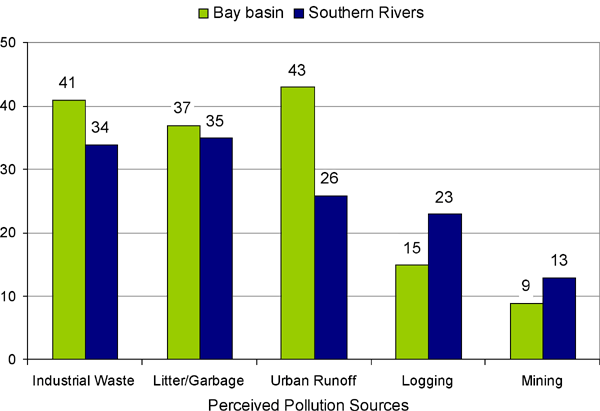
When asked what contribution their farm makes to water quality degradation, the majority of producers in both regions believed their farm did not contribute to reduced or impaired water quality (Table 3). Respondents from both regions indicated that industrial wastes and litter or garbage were the significant sources of pollution; more respondents in the Bay basin believed urban sources contributed to water pollution (Figure 2). The vast majority of respondents from both regions (90% from the Bay basin and 85% from the Southern Rivers region) agreed with the statement "water pollution can best be controlled through educational programs that encourage farm operators to adopt BMPs" (Table 4).
| Region | Possible Response | |||
| Contributes Significantly | Contributes Small Amount | Does Not Contribute | Do Not Know | |
| Bay basin | 1 | 34 | 59 | 6 |
| Southern Rivers | 1 | 26 | 61 | 12 |
Figure 2.
Perceived Causes
of Pollution in Virginia's Bay Basin and Southern Rivers Region
| Survey Statement | Bay Basin | Southern Rivers |
| The best way to control pollution is through enforcement of strict regulations | 31 | 44 |
| Water pollution can best be controlled through educational programs that encourage farm operators to adopt BMPs | 90 | 85 |
| Farm practices designed to protect water quality reduced farm profits | 35 | 38 |
| Government should pay a greater share of the costs associated with BMP implementation | 60 | 60 |
Best Management Practice Implementation
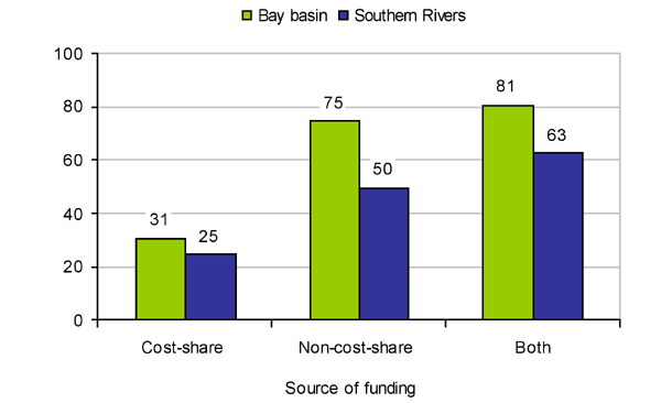
Approximately 81% of producers in the Bay basin, versus 63% of producers in the Southern Rivers region, have implemented some type of agricultural BMP (Figure 3). The majority of the BMPs in both regions were implemented without cost-share assistance, and the percent of respondents who implemented BMPs with cost-share funds was similar between the two regions. However, there were more producers in the Bay basin who had implemented BMPs without cost-share assistance. Survey results indicated that in the Bay basin, 4.4 non-cost-share BMPs were implemented for every cost-share BMP, while 3.6 non-cost-share BMPs were implemented for every cost-share BMP in the Southern Rivers region.
Figure 3.
Percent of Producers Who
Implemented BMPs With Cost-Share Funds, Without Cost-Share Funds, and
Both With and Without Cost-Share Funds (Combined) in Virginia's Bay
Basin and Southern Rivers Region
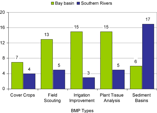
To further examine the differences in BMP implementation levels between the two regions, the ratios of the number of specific BMPs implemented without the use of cost-share funds to those implemented with cost-share funds were compared for various BMPs (Figure 4). The ratio was higher in the Bay basin than in Southern Rivers region for cover crops, field scouting, irrigation improvement, and plant tissue analysis. Each of these BMPs has traditionally been associated with production of high-yield field crops that are primarily grown in the Bay basin (corn, small grains, and soybeans). In the steeper Southern Rivers region the ratio for sediment detention basins was much greater than in the Bay basin. This difference is likely due to the steeper topography in most of the Southern Rivers region, as compared to the topography in the Bay basin.
Figure
4.
Ratio of
Non-Cost-Share to Cost-Share Funded BMPs Implemented in the Bay Basin
and Southern Rivers Regions of Virginia
Conclusions
Although there were many similarities in farm characteristics and producers' attitudes toward water quality issues, BMP implementation is greater in the Bay basin. Across the state, a majority of producers have implemented BMPs, and most have implemented BMPs without the use of cost-share assistance. The fraction of survey respondents who implemented BMPs without cost-share assistance and who implemented BMPs regardless of the funding source were both higher in the Bay basin than in Southern Rivers region of Virginia. This difference may be in part due to a more focused, longer-term coordinated BMP programmatic effort in the Bay basin. However, it is also likely that the non-cost-share/cost-share ratio in a particular basin is a function of the dominant type of agriculture being practiced in that basin, the level of BMP and water quality educational efforts, as well as the prevalent socioeconomic circumstances.
In both regions of Virginia, producers who had implemented more non-cost-share practices tended to agree with the statement, "Water pollution can best be controlled through educational programs that encourage producers to use BMPs." To maintain this positive influence and to increase the current ratio of non-cost-share BMP for every cost-share BMP implemented (4.4), the information presented here suggests that future educational programs should focus on the water quality benefits associated with implementing BMPs.
Acknowledgments
Funding for this study was provided, in part, by the Virginia Department of Conservation and Recreation, Division of Soil and Water Conservation, Richmond, Virginia.
References
Bultena, G. L., & Hoiberg, E. O. (1986). Sources of information and technical assistance to farmers in controlling soil erosion. In: Conserving Soil: Insights from Socioeconomic Research, S. B. Lovejoy and T. L. Napier (Editors). Soil Conservation Society of America, Ankeny, IA. pp. 71-82.
CBP (Chesapeake Bay Program). (2004). Available at: http://www.chesapeakebay.net
Environmental Protection Agency (EPA). (2003a). National management measures to control agricultural sources of NPS pollution. Office of Water, U.S. EPA, 314 pp.
Gomez, B. (1995). Assessing the impact of the 1985 farm bill on sediment-related NPS pollution. Journal of Soil and Water Conservation 50(4):374-377.
Hoban, T. J., & Wimberley, R. C. (1992). Farm operators' attitudes about water quality and the RCWP. Proceedings of the National RCWP Symposium. pp. 247-253.
Logan, T. J. (1990). Agricultural best management practices and groundwater protection. Journal of Soil and Water Conservation 45(3):201-206.
Napier, T. L., Thraen, C. S., & Camboni, S. M. (1988). Willingness of land-owners to participate in government-sponsored soil erosion control programs. Journal of Rural Studies 4(4):339-347.
Novotny, V., & H. Olem. (1994). Water quality: Prevention, identification, and management of diffuse pollution. New York: Van Norstrand Reinhold.
USEPA (United States Environmental Protection Agency). (2003b). Technical support document for identification of Chesapeake Bay designated uses and attainability. Office of Water, U.S. EPA, 277 pp.
USEPA (United States Environmental Protection Agency): (2002). 2000 national water quality inventory, Office of Water, USEPA. Available at: http://www.epa.gov/305b/2000report
Virginia Department of Agriculture and Consumer Services (VDACS). (1992). Virginia agricultural statistics summary. Commonwealth of Virginia, Department of Agriculture and Consumer Services.
Virginia Department of Conservation and Recreation, Virginia Division of Soil and Water Conservation (VDCR). (2004). Virginia agricultural BMP cost-share program database. Commonwealth of Virginia, Department of Conservation and Recreation. Available at: http://192.206.31.52/cfprog/dswc/bmpprm.cfm