June 2006 // Volume 44 // Number 3 // Tools of the Trade // 3TOT4
Watershed Learning Activity: Coming to Terms with Geographic Scale
Abstract
Want better dialogue in your watershed
group? Problems may result from participants' misunderstanding of geographic
scale. The Watershed Learning Activity can foster an understanding of the
importance of geographic scale through group-based experiential learning
that combines aerial photography and conceptual change theory. Try it at
your next watershed meeting.
Introduction
The concept of geographic scale presents challenges as well as opportunities for watershed educators. "Scale" is at the heart of watershed issues. Stakeholders, such as private landowners, farmers, scientists, and policy makers, can live and work in seemingly the same place, i.e., a particular watershed, but may think very differently about the landscape (Fisher, 2000; Harris, De Lasaux, & Kocher, 2000). A lack of understanding of geographic scale can contribute to disagreement among stakeholders and may diminish the impact of watershed education programs.
This article presents a learning activity about scale for use in watershed education programs. The Watershed Learning Activity helps stakeholders develop an appreciation for the variety of ways that individuals "know" their environment and an understanding of the influence of scale in shaping perspectives on watershed issues.
Diversity and Problem Solving
Extension educators put diversity to work by encouraging stakeholders to share ideas, values, and perspectives through dialogue and partnership projects (Fisher, 2000; Conway, Godwin, Cloughesy, & Nierenberg, 2003). A successful collaborative decision-making process demands that stakeholders not only understand management options, but that they are also aware of the perspectives of other members. Consequently, programs that elicit, rather than avoid, diversity produce better solutions.
Bringing diversity to bear on decision-making, however, is challenging (Conway et al., 2003). Watershed stakeholders may express ideas about the landscape that arise from experiences with land and water that presume a particular scale. Greater awareness of the frame of reference for their experiences can help stakeholders talk more productively across differences.
Conceptual Change Theory
The abstract nature of the concept of scale challenges Extension educators. Consequently, we developed the Watershed Learning Activity, designed according to principles of conceptual change theory from science education (Posner, Strike, Hewson, & Gertzog, 1982).
True conceptual change is hard won. It requires eliciting prior knowledge, engaging in inquiry or discovery activities, and reflecting on results (Posner et al., 1982). Conceptual change theory is a constructivist perspective that presumes that individuals construct their own knowledge rather than receive knowledge passively. Extension educators have applied conceptual change theory to the development of science-based curricula for youth (for example, Williamson & Smoak, 1999), and to pesticide safety educator training (Grudens-Schuck, Cramer, Exner, & Shour, 2003).
Learning Activity
The recommended use of this activity is at the beginning of a workshop series, conference, or as an orientation tool for a new watershed group. The exercise was piloted twice in 2005, first with a group of eight adults, ages 25 to 55, who were familiar with agricultural and natural resources issues, but were not trained in landscape ecology, and second, with a class of graduate students who possessed intermediate knowledge of landscape ecology.
Learning Outcomes
-
Attendees will develop a concept of geographic scale consistent with a lay scientific understanding,
-
Attendees will value the role of scale in watershed management, and
-
Attendees will acknowledge the existence of multiple perspectives on scale.
Materials, Facilities and Time
-
Index cards in two or three different colors.
-
One dark, medium-tip marker per participant.
-
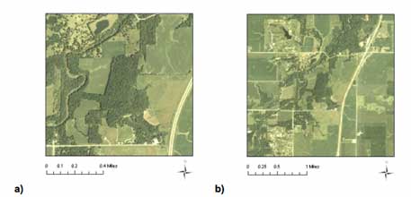
Aerial color photographs (one per participant), at least 5 X 7 inches, of the same location at two (or three) different scales. It is essential that the location be the same, but the area covered by the photographs (i.e., extent) should be different. We used photographs of a well-known local natural area (Figure 1). Free downloads of aerial photographs can be obtained from TerraServer-USA (Microsoft Corporation) at http://terraserver-usa.com.
-
White board or flip charts, with markers.
-
Tape for fastening index cards to board.
-
Room or outdoor area that permits group discussion.
-
Article by Cheng and Daniels (2003).
-
Estimated time for the activity is 40 minutes to 1 hour.
Figure 1.
Aerial Photographs of McFarland Park in Story County, Iowa, at Two Different Scales:
a) 1:10,000 and b) 1:24,000.
Photographs are a courtesy of Iowa State University, Geographic Information Systems Facility - Iowa Geographic Map Server, and the USDA Farm Service Agency.
Directions
Small Group Formation and Silent Writing
Time: Five to 10 minutes
-
Form small groups, two to six per group.
-
Distribute photographs and cards. Provide each group with a photograph of a section of a watershed at varying scales. Provide Group #1 with Scale A, Group #2 with Scale B, and so forth. Distribute two to five different colored index cards and one marker per person. Each group should have note cards of the same color, but different color from other groups.
-
Generate ideas. Direct participants to write one or two words per card that explain how they would "know" (as individuals) the location in the photograph. Do not tell participants that groups have different photographs.
Categorization of Ideas
Time: 20 to 30 minutes
-
Collect photographs. Place them where they cannot be seen.
-
Categorize ideas. Instruct participants to gather around a table, thus forming one large group. Direct them to place ideas (on cards) into categories by talking together and coming to agreement (per Chambers, 2002).
-
Label categories. Ask participants to agree on labels for the main categories (of ideas on the cards). Write the labels on a white board or flip chart. Tape the respective index cards below each category label.
-
Discuss categories. Elicit discussion about the categorization process, including disagreement and proposals for changing categories or moving cards.
Discussion
Time: 15 to 20 minutes
-
Reveal photographs. Show all photographs to participants. Allow participants to voice insights. There may be surprise at the (mild) deception.
-
Discuss location of index cards. Indicate the location of the different colored index cards and associated scale. Point out if categories were composed of ideas from all groups (i.e., from multiple scales) or one group (i.e., from a single scale).
-
Discuss implications for watershed education. Direct participants to discuss implications of scale to watershed management. Introduce expert knowledge by reading or showing selections from Cheng and Daniels (2003) (selections below).
Stakeholders involved in place-based planning processes at small geographic scales articulate ways of knowing the place that reference specific place features (p. 844).
Stakeholders involved in place-based planning processes at relatively large geographic scales articulate ways of knowing the place that reference symbolic abstractions and generalizations (p. 844).
Reflections on Implementation
Participants in the first pilot study developed eight categories that were both specific (e.g., farming) and abstract (e.g., human experience), indicating the diversity of ways that people know a place.
- Farming
- Structures
- Human experience / landmarks / orientation
- Colors
- Conceptual / hierarchical
- Combination of woods & water
- River system / drainage system / water
- Woods
The participatory process of categorization encouraged the formation of new ideas and also generated disagreement. Confrontations helped the group to examine their beliefs (i.e., critical reflection) and contributed to an appreciation of different ways of knowing places.
Conclusion
Successful collaborative decision-making about watershed issues is more likely to succeed if stakeholders advance their understanding of geographic scale. This learning activity was designed to stimulate learning about scale, leading to better decisions by multi-party stakeholder watershed groups. The activity is anticipated to work in a range of settings for Extension education, secondary education, and the college classroom.
References
Chambers, R. (2002). Participatory workshops: A sourcebook of 21 sets of ideas and activities. Sterling, VA: Earthscan Publications.
Cheng, A.S., & Daniels, S.E. (2003). Examining the interaction between geographic scale and ways of knowing in ecosystem management: A case study of place-based collaborative planning. Forest Science, 49(6), 841-854.
Conway, F.D.L., Godwin, D., Cloughesy, M., & Nierenberg, T. (2003). Watershed Stewardship Education Program--A multidisciplinary extension education program for Oregon's watershed councils. Journal of Extension [On-line], 41(4). Available at: http://www.joe.org/joe/2003august/a4.shtml
Fischer, F. (2000). Citizens, experts, and the environment: The politics of local knowledge. Durham, NC: Duke University Press.
Grudens-Schuck, N., Cramer, J., Exner, D.N., & Shour, M. (2003). The new adult education: Bringing peer educators up to speed. Journal of Extension [On-line], 41(4). Available at: http://www.joe.org/joe/2003august/a2.shtml
Harris, R.R., De Lasaux, M., & Kocher, S. (2000). Process and reality: Working with a local watershed organization to develop a restoration effectiveness monitoring program. Journal of Extension [On-line], 38(2). Available at: http://www.joe.org/joe/2000april/a4.html
Posner, G.J., Strike, K.A., Hewson, P.W., & Gertzog, W.A. (1982). Accommodation
of a scientific conception: Toward a theory of conceptual change. Science
Education, 66(2), 211-227.
Williamson, R., & Smoak, E. (1999). Creating a Down-to-Earth approach to teaching science, math and technology. Journal of Extension [On-line], 37(3). Available at: http://www.joe.org/joe/1999june/iw3.html