October 2005 // Volume 43 // Number 5 // Ideas at Work // 5IAW1
Strengthening Integration of Land Use Research and Outreach Through Innovative Web Technology
Abstract
The University of Connecticut has long
used geospatial information as a component of its Extension programs on land
use policy. In recent years, increased use of remote sensing and geographic
information systems has created a "technology gap," as sources
of data outpace the ability of many communities to make use of it. The NEMO
program has developed several Web sites that attempt to bridge this gap.
Connecticut's Changing Landscape uses a range of approaches to disseminate
information to audiences of varying geospatial sophistication. These techniques
help Extension to serve a broader audience and also strengthen the ties between
research and outreach
Introduction
Local land use officials are a critical audience for Extension education and assistance (Arnold, 2000). The University of Connecticut (UConn) Cooperative Extension System has had a focus on educating local land use decision makers since the inception of the Nonpoint Education for Municipal Officials (NEMO) Project in 1991. This program has been the catalyst for local public policy changes in many of Connecticut's communities, inspiring community-driven planning efforts and changes to land use regulations and policy (Rozum & Arnold, 2004). The Connecticut program has also become the coordinating center of the National NEMO Network, a confederation of similar projects in 32 states (Rozum, 2003).
The educational foundation for NEMO has always been face-to-face Extension workshops for local decision makers. The research foundation of the program relies heavily on remote sensing (RS) landscape research, mediated through geographic information system (GIS) technology. At the time of the project's inception, RS was virtually unused at even the state level within Connecticut, and GIS technology was just emerging from its infancy as a costly and labor-intensive tool. As a result, NEMO's use of these technologies was mostly confined to inserting carefully crafted images and maps into educational presentations (Arnold Crawford, Gibbons, & Jeffrey, 1993).
Today, these technologies are not as arcane to the average citizen. Advances in software have opened up many new and exciting potential applications for geospatial technology in land use planning. Just as important, the digital revolution has made many individuals and local agencies much more comfortable with using computers in general and geospatial applications in particular. However, "technology gaps" still exist--both between geospatial "have" and "have not" communities and with the ability of users to access the proliferating sources of data.
With these trends in mind, NEMO has been engaged in a number of efforts that attempt to improve the understanding of and access to RS research data by community officials, thus enhancing the integration of our research and outreach efforts. NEMO's work is done under the banner of the Center for Land Use Education and Research (CLEAR), formed in 2002 as a formal partnership between the landscape research and land use education efforts at the College of Agriculture and Natural Resources.
Connecticut's Changing Landscape
Connecticut's Changing Landscape (CCL) project demonstrates, for the first time, both the current state of Connecticut's landscape, and how it has changed over the last two decades. The first phase of this ongoing project was released in early 2004, just as debates on "smart growth" legislation were raging in the media and the Connecticut Legislature. As a result, interest both from the public and local and state government has been high, and CLEAR and NEMO principals have been kept busy conducting workshops on project results for a wide variety of clientele groups. Study results have also been incorporated into other, longstanding topical NEMO educational workshops.
In the past, these workshops would've been the extent of the access to the research information provided by NEMO. However, the broad interest in the land cover change information convinced the CLEAR/NEMO team to create the CCL Web site <http://clear.uconn.edu/>, which provides project data and information via several methods. For those unfamiliar with GIS technology or spatial information, tables, charts and other graphics summarizing the data are provided on the Statewide Data page. These are accompanied with maps provided in Adobe PDF that can be viewed or downloaded using the freely available Adobe Acrobat reader.
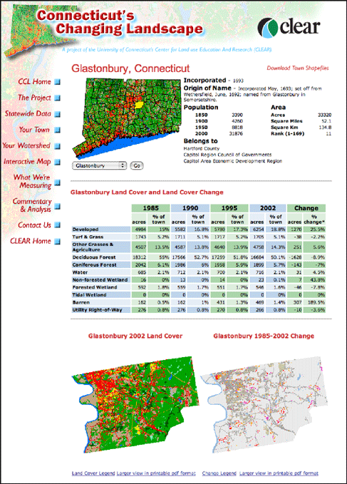
At the "Your Town" and "Your Watershed" portions of the site, information is provided for each of the 169 towns and 44 regional watersheds in the state using dynamic Web page technology (Figure 1). This technology enables a level of efficiency for the information provider while allowing a "customized" experience for the information consumer.
Figure 1.
The Your Town Section of the CCL Web Site.
For mid-level users who would like to interact with the data but do not have GIS software, an interactive mapping section of the site was created. The interactive map allows users to manipulate data (such as turning data layers on and off, zooming, and panning) and to print their final product all within an Internet browser. NEMO staff have customized the interface to include tools, legends, and links to the other educational resources within the Web site.
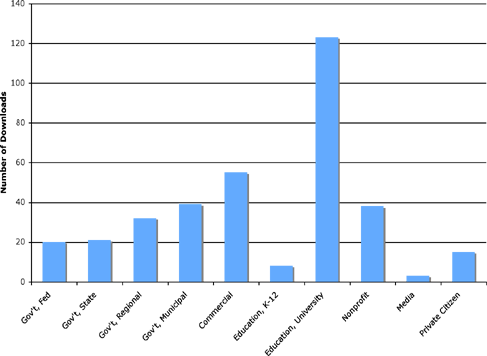
GIS and RS users are provided with direct access to the data via a Data Download page. The entire study area can be downloaded, along with subset areas of the state of Connecticut. Over 350 downloads have been logged to date, by groups such as regulatory agencies, nonprofit organizations, city planning offices, consulting firms, and academia (Figure 2).
Figure 2.
Number of Downloads Initiated by Government Agencies, Organizations, and Academia
from January 2004 Through January 2005.
More sophisticated analyses will be added to the CCL project in the near future, continuing to challenge the NEMO team to relate this information in multiple formats. Another project, Focus on the Coast <http://nemo.uconn.edu/coastal/>, has provided a testing ground for additional Web/GIS technologies. These include ESRI ArcReader software, which allows the project team to create downloadable "map packages," and other software, which allows users to connect their desktop GIS systems to data being served by the project.
Closing the Technology Gap
Geospatial technology and information is no different than any other subject matter brought to the community by Extension. Extension professionals wishing to foster understanding and use of the information must go beyond merely providing data and focus on crafting value-added "translation" of these technologies. Our use of geospatial technology has not been a linear evolution from simple to complex uses. Rather, as advances in geospatial technology enable more approaches, the project has diversified its array of informational options to enhance the workshop-based educational toolbox available to communities. This not only improves our outreach services to our clientele, but provides a more direct and integrated connection between outreach and ongoing research.
Based on 13 years of work by the NEMO Project and the growing use of this technology for community decision making, we believe this integration constitutes a major enhancement of our project's effectiveness. Through this work and work being conducted by our peers in National NEMO Network, we will continue to foster creativity in bringing geospatial resources and technology to community decision makers.
References
Arnold, C. L., Jr., Civco, D. L., Prisloe, S., Hurd, J. S., & Stocker, J. (2000). Remote sensing-enhanced outreach education as a decision support system for local land use officials. Photogrammetric Engineering & Remote Sensing 66(10):1251-1260.
Arnold, C.L. (2000). Land use is the issue, but is land grant the answer? Journal of Extension [On-line] 38(6). Available at: http://www.joe.org/joe/2000december/comm1.html
Arnold, C. L., Crawford, H. M., Gibbons, C. J., & Jeffrey, R. F. (1993). The use of Geographic Information System images as a tool to educate local officials about the land use/water quality connection. In: Proceedings of Watersheds '93, Alexandria, Virginia, pp. 373-377.
Rozum, J. S. & Arnold, C. L. (2004). Putting communities in charge: A progress report on an educational support system for local land use decision makers. Publication of the University of Connecticut Cooperative Extension System and the Center for Land Use Education and Research. Publ. #041215.1, 35 pp.
Rozum, J. S. (2003). NEMO U-3 conference marks growth of NEMO network. Nonpoint Source News-Notes Issue #72, September 2003. Pp. 8-9.