December 2004 // Volume 42 // Number 6 // Tools of the Trade // 6TOT2
3D Visualization in Community-Based Planning
Abstract
A new wave of recently developed Geographic Information Systems (GIS) software
provides for higher levels of analysis, modeling, and visualization for community
development and planning. Beyond the typical 2D static map produced through
most GIS software, more recent developments allow for much more detailed 3D
visual graphics. CommunityViz allows for predictive modeling, data integration,
and 3D visualization. It is the utility of this last capability that is examined
in an Extension pilot program in an Iowa community. Based upon this application,
the potential of this type of software for Extension education is discussed.
Introduction: GIS and Extension
The United States Department of Agriculture and its Cooperative State Research, Education and Extension Service already funds Geographic Information Systems (GIS) Extension education programs in a number of states and plans to expand this effort through the Geospatial Extension Specialists (GES) Program (CSREES, 2003). Programming for agriculture, youth, water quality, community development, and Extension administration has become more common (CSREES, 2003; Estrada & Steil, 1997).
The advancement and availability of GIS technology along with other analytical and modeling tools has been increasingly utilized in community planning and development, but the lack of integration and interactivity among these tools has dwarfed their combined potential. To bridge this gap, the Orton Family Foundation has put together an innovative set of tools for rural community planning called "CommunityViz" that integrates community modeling with GIS and enables users to envision alternatives for their community's future (The Orton Family Foundation, 2002).
3D Modeling Capability of CommunityViz
In the process of community planning, prognosticating the future and dealing with potential consequences has always been a challenge to planners, decision-makers, and stakeholders in a community. Community planning is often further complicated by competing interests groups divided by issues that span both space and time (Myers, 2001). CommunityViz provides tools through which residents and leaders alike can better envision the consequences of alternative plans and decisions. As described by the developers of CommunityViz 1.3, a brief introduction to the three integrated modules is provided here (The Orton Family Foundation, 2002: 2).
-
"Scenario Constructor is a scenario analysis tool that provides the underlying framework for the alternative-comparison capabilities of CommunityViz. It also provides a rich set of quantitative impact analysis capabilities, offering the functionality of a 'spatial spreadsheet' that can perform numerical computations on geographic data in real time."
-
"SiteBuilder 3D enables users to build photo-realistic, three-dimensional, interactive models of their land-use proposals. Once built, the models allow virtual 'fly-through' and exploration, giving users the ability to visualize land-use proposals and even change them in real time."
-
"Policy Simulator uses agent-based modeling techniques to simulate likely future impacts of community planning proposals, providing planners with a view of likely economic and demographic outcomes years into the future."
These modules function as extensions to ArcView GIS and provide an extensive set of decision-support tools to help users analyze and visualize information about their community and make informed decisions.
Among the three modules of CommunityViz 1.3, SiteBuilder 3D enables the user to visualize and navigate the landscape in a virtual 3D environment. As shown in Figure 1, the scene was created with a base terrain generated from point features with elevation information. The base terrain was further textured using a satellite image. Buildings were extruded to their heights and textured with the provided 2D textures. Finally, 3D tree models were selected from the model library and placed onto the base terrain.
Figure 1.
A 3D Scene Created with SiteBuilder 3D

An Envisioning Project: Altoona's New City Center
The Iowa State University Extension Service in conjunction with the Department of Community and Regional Planning conducted a pilot project using CommunityViz to help the city of Altoona visualize its proposed comprehensive plan. The central theme of the Altoona comprehensive plan proposal is the transformation of its Eighth Street corridor into a downtown district that would give unique character to the city. Several alternatives were visualized, and the city decided to create a new city center in the downtown district.
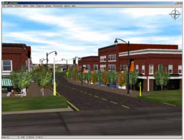
The Altoona envisioning project began with a data needs study to identify the required data sets, their availability, and formats. These data sets include a digital elevation model (DEM), aerial photographs, site plans, street network, and so on. Next, the proposed new city center was created in a virtual three-dimensional digital model using the SiteBuilder 3D module (Figures 2 and 3).
Figure 2.
The 3D Model of Altoona's New City Center
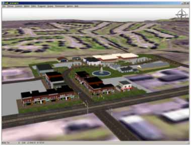
Figure 3.
A Closer View of Altoona's New City Center
Real-time navigation in the 3D environment is also supported by SiteBuilder 3D. The user can control the motion mode, speed of movement, and eye point distance from the ground so she or he can virtually drive or walk around town or even fly over it with ease. A user-defined tour in the 3D environment can be created by putting together a series of control points that define the tour path. Tours can be recorded and saved as animation files in .avi format. The end result is the development of realistic visual models from which local decision makers can reach informed decisions.
Potential Applications in Extension
CommunityViz 1.3 is an invaluable decision-support tool that can be easily integrated into Extension programming. Its unique combination of spatial analysis, 3D visualization, and long-term forecasting capabilities greatly enhances the exploratory and predictive power for a community to plan alternative futures. CommunityViz is also an effective educational tool that encourages visionary and strategic thinking in the planning process.
In addition to its analytical capabilities, CommunityViz has great potential to facilitate consensus building, citizen participation, and proactive planning. Representation of a community's future can serve as an essential means for gaining agreement (Myers & Kitsuse, 2000) and uniting people toward common goals. To that end, CommunityViz provides a dynamic digital environment to enhance decision-making and community planning.
Conclusion
While this 3D Extension programming is in its development stages within Iowa, CommunityViz 1.3 appears to have a great potential as an educational and planning tool in the area of community resource development. It is an innovative software suite that enables the user to perform real-time decision analysis and exploration, interactive 3D visualization and navigation, and long-term policy outcome forecasting within the already popular ArcView GIS environment. Beyond data generation, it provides a visualization of the impacts of decisions useful to the general public and decision-makers alike. It is a tool that offers a more proactive approach for Extension to assist communities in envisioning and shaping their future environment through informed planning.
References
Cooperative State Research, Education and Extension Service. (2003). Geospatial Extension specialists program Web site: http://www.csrees.usda.gov/fo/fundview.cfm?fonum=1092
Estrada, J. K., & Steil J. R. (1997). Evaluating the effectiveness of adopting a GIS in the Extension Service: Evidence from the Cooperative Extension Service at Mississippi State University. Journal of Extension [On-line], 35(5). Available at: http://www.joe.org/joe/1997october/a1.html
Myers, D. (2001). Putting the future in planning. Journal of the American Planning Association, 67(4), 365-367.
Myers, D., & Kitsuse, A. (2000). Constructing the future in planning: A survey of theories and tools. Journal of Planning Education and Research, 19(3), 221-231.
The Orton Family Foundation. (2002). CommunityViz: Scenario Constructor Version 1.3 User Manual. Boulder, CO: CommunityViz.