October 2003 // Volume 41 // Number 5 // Feature Articles // 5FEA5
Opportunities and Challenges for Land Use Planning in the Intermountain West
Abstract
Land use planning is a persistent challenge for rural communities of the
Intermountain West. A role for Land-Grant Universities in planning activities
is provided through lesson learned in four county projects. Inclusiveness,
reciprocal communication, transparency, and objectivity are illustrated
as keys to success in applied research and outreach programming.
Introduction
Arnold (2000) proposes an expansion of the Land-Grant University's (LGU) traditional rural research and outreach program to include county-level planning assistance. Rural residential development presents a planning challenge to counties throughout the western United States. County governments may lack adequate time, resources, and expertise to plan. Seidl (2001) documents the disparities between local planning needs and the existence of expertise among potential service providers. In the Intermountain West, rural communities share the following planning challenges:
- High population growth rates (US Census, 2001; Taylor & Lieske, 2002; Wyoming State Department of Administration and Information, 2001);
- Many natural amenities, including abundant public lands, the management of which is commonly outside of local influence;
- Few personnel and relatively little local planning expertise; and
- The possibility of growth damaging the very features of the human and natural landscape that were valued in the first place (Collinge, 1996; Theobald, Gosnell, & Riebsame, 1997).
Seidl (2001) found that he implications of growth on local land and other natural resources use were the most pervasive concerns of Colorado County Commissioners.
This article illustrates opportunities for LGU county level planning assistance through a synthesis of four recent projects in the Intermountain West; Moffat County, Colorado; Sheridan County, Sublette County, and Uinta County, Wyoming. Through the adaptation of a comprehensive planning model and recently published accounts, strategies for LGU researchers to tackle county planning challenges in a manner acceptable to local officials are proposed. The four county projects selected are illustrative of the broader planning and development issues facing much of the Intermountain West because each focal county reflected the following:
- Has traditions rooted in livestock ranching;
- Is currently located in a high growth region;
- Contains significant federal public lands, including BLM tracts, national monuments, parks, and/or recreation areas; and
- Was considering revising or generating a county comprehensive plan that would include land use at the time of the proposed LGU study.
This article describes specific planning problems confronting the four counties within the broader context of rural community planning. A schematic is provided that serves as a template for addressing county level planning needs. Given this overall planning approach, ways to establish an effective working relationship with the four counties are addressed. Land use planning focus group and survey results and interpretations are provided.
It should be noted that the nuances of the planning process, in terms of who is contacted and issue development, are as important here as the research results. How the results are viewed and valued by county officials and citizens is based largely on how inclusive, location specific, and objective the process is perceived to be.
Engaging the Counties
Challenges and County Needs
Daniels (1999, p. 45) identifies eight obstacles to effective growth management in rural fringe areas:
- "Fragmented and overlapping governments, authorities, and special districts;
- The large size of fringe areas;
- Lack of a community, county, or regional vision;
- Lack of a sense of place and identity;
- Newcomers, social conflicts, and rapid population growth;
- The spread of scattered new development;
- Too few planning resources; and
- Outdated planning and zoning techniques."
Many counties in the Intermountain West face these obstacles. Efforts to address planning issues were complicated by the size of the counties and anticipated monitoring and enforcement costs (Obstacle 2). The counties encompass state, federal, and municipal lands, suggesting jurisdictional problems (Obstacle 1).
Institutional change touches on several of the obstacles identified by Daniels. Three of the counties had planners. All three sought employment elsewhere either during or immediately after the LGU projects. The planning and zoning boards in each county consisted of volunteers appointed for short terms. County commissioners and other elected officials changed due to electoral outcomes. The counties had scant resources and lacked planning continuity upon which to revise their respective land use plans (Obstacles 7 and 8) due to these circumstances.
Researchers from the University of Wyoming, and, for one county, Colorado State University, moved to address the planning challenges identified within the four counties. The LGU team acted to provide documented, defensible, and planning-relevant information, specifically helping the counties to address Obstacles 3, 4, 7 and 8.
Addressing County Needs
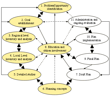
The 11-step planning process used by the researchers is illustrated in Figure 1. The research work assisted with land use planning efforts in steps 1-6 and 8, shaded in Figure 1. Focus groups, consisting of officials and residents from diverse backgrounds, were employed to identify issues as well as to develop working vocabularies (Step 1). The focus groups served as visioning opportunities around the following themes:
- What do you like about your county?
- What would you prefer not occur?
- What are you willing to do to address your preferences?
Local knowledge was utilized to help frame the issues to be addressed in a countywide survey (Step 2). Population and economic sector comparisons provided regional level inventory and analysis (Step 3)(see, for example, Taylor & Lieske, 2002). Detailed studies (Step 5)--cost of services assessment (Coupal, McLeod , & Taylor, 2002), GIS mapping and assistance (Bastian, McLeod, Germino, Reiners, & Blasko, 2002), review of existing plans and regulations as well as the survey of land use and planning preferences--provided information for local inventory and analysis (Step 4) of existing social, economic, and physical conditions in the area. The items important for the revised county land use plan come from the focus group visioning and planning survey results (Step 6). These two efforts provided citizen education, and involvement, as did a public presentation of the survey results (Step 8).
Figure 1.
A Description of the Planning Process
Note: Shaded areas indicate where the LGU efforts fit into the planning process. Darker arrows indicate flow from step 1 through step 11. Lighter arrows suggest feedback between earlier and later steps. Dashed arrows indicate other potential modifications in the planning process (adapted from Steiner, 1991:10). |
County Partnerships
Successful projects in each of the counties depended to a large extent on the degree of partnering with local officials. Each prospective partner county was informed that research efforts were funded by federal, state, or other grant dollars. Partners were assured that the survey would be available for scrutiny prior to administration and that survey outcomes would be provided to county officials prior to release to the public.
County officials and local agencies need to buy into this process for research to be useful. When human and financial resources are expended, the processes and outcomes are less readily dismissed. The three counties that made contributions took a greater interest in the research outcomes as well as attempted to integrate findings into their land use planning. This resulting interest also occurred when county Extension personnel and other county officials participated in the LGU planning studies.
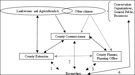
Stakeholder Structure
The requirement for parallel tracks of communication is underscored by the complexity of stakeholder relationships with county officials. Figure 2 describes a conceptual description of stakeholder structure in a county. Research that engages a solitary "entry" into a county without considering the others risks compromising the objective value of the information obtained.
The lesson for research partnering is that there must be ongoing communication with multiple parties. The process seems to be received better and offer usable outcomes if it is open and inclusive. Initial meetings with stakeholders (developers, agriculturalists, and county officials in addition to focus groups and survey responses) promoted a sense of community involvement as well as ownership of the process and its outcomes.
Entry 1 provides a natural fit for a land use planning process (Figure 2). Entries 2 and 3 are vital also because of their connections with landowners, ranchers, and economic development. Entry 4 allows the ongoing engagement of the populace via focus groups, those sampled to receive the survey, and media outlets such as the local papers and radio. This fostered a bilateral transfer of information between researchers and the county households. Households were kept apprised of the impending land use planning process and outcomes to date. Researchers and officials obtained insights into how respondents and participants viewed their counties and the land use planning process.
Figure 2.
Communication Between LGU Researchers and the Counties
Research efforts need to acknowledge that there are agendas and priorities specific to counties. Good faith efforts to address local interests, in addition to researchers' interests, were made in these projects. These additions served to inform local planning concerns and to garner support from by local officials.
Data Collection Methods
The data collection process started with a series of focus groups of selected citizens. The local planner and county commissioners were involved in choosing focus group participants. A survey instrument was designed from the information derived from the focus groups and pre-tested in every county. Each county survey received scrutiny from county and LGU personnel. A summary of the group number and type for each county is presented in Table 1.
|
County |
Type of Participants |
# Focus Group Sessions |
Total Participants |
|---|---|---|---|
|
Sublette |
Landowners, General Public |
12 |
40 |
|
Uinta |
Landowners, General Public, Public Officials |
6 |
25 |
|
Sheridan |
Landowners, General Public, Public Officials |
4 |
20 |
|
Moffat |
Landowners, General Public, Public Officials |
9 |
30 |
The Survey
Mail surveys were conducted using Dillman's (1978) total design method. A random sample was taken from a list of all county households and out-of-county landowners. Sublette County was the only exception, because it was the first and best funded. Approximately 100 % of all households and non-resident landowners were sent a survey. The survey was administered through four to five mailings in each county. Response rates are given in Table 2. Interestingly, nonresident landowners took a greater interest in the survey process than did residents.
|
County |
Year |
Sample Size* |
Residents Responding |
Nonresident Landowners Responding |
Total Rate |
|---|---|---|---|---|---|
|
Sublette |
1996 |
4,211 |
46% |
59% |
52% |
|
Uinta |
1999 |
1,902 |
42% |
50% |
43% |
|
Sheridan |
1999 |
1,881 |
46% |
56% |
48% |
|
Moffat |
2000 |
2,260 |
56% |
54% |
55% |
Results
Results of the four survey and analysis efforts are presented in Table 3. Survey results helped determine the issues germane to the planning process. Respondents identified characteristics of private open spaces in the survey that were important:
- Western livestock culture,
- Solitude,
- Scenery,
- Water quality/supply,
- Wildlife, and
- Recreation.
The extent of agreement within, as well as between, counties is of interest. The preferred land uses and activities on rural lands as well as potential sources of conflicts or concerns appear to be the same across the counties. Given the sample sizes and the survey response rates, these outcomes point to widespread concurrence about what is valued and what should be avoided. Maintaining open space and extensive rangeland agriculture, with the attending environmental amenities, appears to be a strong, widely held planning preference. This offers direction for revising a land use plan. It also sets the groundwork for other Intermountain West counties' inquiries into local planning issues.
Support for rural land conservation was found for two types of tools: voluntary (conservation easements) and regulatory mechanisms (zoning and building restrictions). Conservation easements (CE) were viewed as a viable tool in three of four counties. Sublette County had the lowest support for a CE program at 43%. The other three counties showed substantially more support. Rural zoning questions represented the regulatory approach to land management.
Interestingly, a majority of respondents in all counties supported some form of zoning. This result seems counter to conventional wisdom and to other survey results that indicate general preferences for minimal government intervention in private property matters. How zoning is proposed may be more important than the issue of zoning per se.
|
Issues |
Sublette 1,2,3,4,5 |
Sheridan 6 |
Uinta 7,8 |
Moffat 9 |
|
Preferred Land Uses/Outcomes |
% of Survey Respondents Agreeing |
|||
|
Scenery/Open Space |
62 |
93 |
97 |
93 |
|
Wildlife Habitat |
YES* |
84 |
97 |
95 |
|
Ag. Lands/Western |
||||
|
Livestock Culture |
YES* |
63 |
84 |
89 |
|
Recreation |
59 |
80 |
94 |
96 |
|
Concerns w/Rural Residential Development |
% of Survey Respondents Agreeing |
|||
|
Water Conflicts |
NA |
98 |
96 |
77 |
|
Wildlife Conflicts |
NA |
93 |
93 |
73 |
|
Reduced Access to Public Lands |
NA |
90 |
93 |
71 |
|
Preferred Land Use Management Strategies |
% of Survey Respondents Supporting |
|||
|
Land Use Districts (Performance Zoning) |
61 |
78 |
67 |
MAYBE** |
|
Regulation of |
||||
|
Subdivision |
87 |
YES* |
YES* |
NA |
|
Yes to a Conservation Easement Program |
43 |
77 |
78 |
MAYBE** |
* YES = majority responses to a set
of related questions |
||||
Responses to Results
A variety of outcomes occurred following, but not necessarily due to, the research outcomes.
Sublette County initially tabled the survey results. Rapid spillover development from Teton County (Jackson, Wyoming) is occurring. Currently the county is embarking on county land use plan revisions. The county is considering forming a purchase of development rights program. It has requested a county-specific cost of community service study from the LGU.
Sheridan County is in the process of updating its land use plan. The Nature Conservancy is obtaining conservation easements in the county. Large-scale coal bed methane drilling and production is occurring in the east portion of the county, prompting rapid development and attendant planning concerns.
Uinta County is proceeding with its land use plan revisions given the 2002 Winter Olympic exposure and growth of the adjacent Salt Lake City Metropolitan area.
Sublette, Uinta, and Sheridan Counties had personnel who pursued land use planning training opportunities with the Sonoran Institute. All three counties are updating their county land use plans utilizing portions of the LGU research.
In Moffat County, wilderness and monument designation proposals are being addressed as a part of its comprehensive planning process.
Moffat County has hired two individuals to its Natural Resources Management unit, has hired a county planner, and has contracted for an economic base study from the LGU in order to further inform county decision making.
A follow-up phone survey was conducted in September 2002 with the county planning offices to determine the level of awareness about, and perceived usefulness of, the project work in each of the four counties. All four counties had planners in place. All four counties were or recently had updated their county land use plan and were aware of the university research report. All had seen the results and deemed them useful, although one planner indicated that some results were too politically sensitive to incorporate directly into the updated county land use plan. All planners agreed that information provided electronically and in state and regional forums were helpful in their planning.
Conclusions
The counties involved in the research projects have the focus group visioning and the survey results as a means of initiating as well as guiding growth and planning conversations. Where the county commissioners and the local CES educator were informed and local resources involved, the research results tended to be viewed as relevant; project success was a direct function of stakeholder engagement.
Issues and concerns were very similar across the four counties. Zoning and purchase of agricultural conservation easements were not objectionable to the survey respondents. Each tool provides county governments with opportunities to create a plan that incorporates voluntary, market based as well as regulatory, coordinated strategies.
LGU researchers have the opportunity to assist with additional data collection and analysis to target planning strategies preferred by the counties. CES programs should be fashioned to assist with additional data needs and land use plan implementation strategies. The LGU can provide objective, policy-neutral information to various levels of government as they grapple with growth, quality of life, and sustainable resource use.
Acknowledgements
Article findings are the result of research funded by USDA-NRI CGP grants # 99-35401-7742 and # 97-35401-4347 as well as the Agricultural Experiment Station and Ruckelshaus Institute of Environment and Natural Resources, both at the University of Wyoming. Support from Cooperative Extension Service in Colorado and Wyoming as well as the University of Wyoming and Colorado State University are greatly appreciated. Support from Sublette, Unita, and Sheridan Counties in Wyoming and Moffat County in Colorado have made this work possible. Comments from three anonymous reviewers and Glen Whipple have contributed to the quality of the manuscript. All errors herein are the responsibility of the authors.
References
Arnold, C. (2000). Land use is the issue, but is land grant the answer? Journal of Extension [On-line], 38(6). Available at: http://www.joe.org/joe/2000december/comm1.html
Bastian, C., McLeod, D., Germino, M., Reiners, W., & Blasko, B. (2002). "Using GIS to measure environmental and visual amenities when valuing agricultural lands." Journal of the American Society of Farm Managers and Rural Appraisers 43-52.
Bittner, A., McLeod, D., Inman, K., Coupal, R., & Seidl, A. (2002.) Results of a land use and planning survey in Moffat County, Colorado. Department Manuscript. Department of Agricultural and Applied Economics, University of Wyoming.
Center for the American West. (October 2001.) Development, land use, and population trends in the American West. Available at: http://www.centerwest.org/futures/
Collinge, S. (1996). Ecological consequences of habitat fragmentation implications for landscape architecture and planning. Landscape and Urban Planning 36, 1:59-77.
Coupal, R., McLeod , D., & Taylor, D. (2002). The fiscal impacts of rural residential development: An econometric analysis of the cost of community services. Planning and Markets. 5(1): 24-31. Available at: http://www-pam.usc.edu/
Dillman, D. (1978). Mail and telephone surveys: The total design method. New York: Wiley.
Daniels, T. (1999). A cautionary reply for farmland preservation. Planning and Markets. 2(1): 21-22. Available at: http://www-pam.usc.edu/
Inman, K. & McLeod, D. (2002). Property rights and public interests: A Wyoming agricultural lands study. Growth and Change 33(1): 91-114.
Inman, K., McLeod, D., & Coupal, R. (2003). Uinta County: a case study in land use and planning. Journal of the Community Development Society. Forthcoming 33(2).
Inman, K., McLeod, D., & Menkhaus, D. (2002). Rural land use and sale preferences in a Wyoming County. Land Economics 78(1): 78-95.
McLeod, D., Inman, K., Coupal, R., & Gates, J. (2002a.) Results of a land use and planning survey in Sheridan County, Wyoming. Wyoming Agricultural Experiment Station Bulletin #1107. University of Wyoming. Available at: http://www.uwyo.edu/ces/PUBS/b1107.pdf
McLeod, D., Inman, K., Coupal, R. & Gates, J. (2002b). Results of a land use and planning survey in Uinta County, Wyoming. Wyoming Agricultural Experiment Station Bulletin #1106. University of Wyoming. Available at: http://www.uwyo.edu/ces/PUBS/b1106.pdf
McLeod, D., Kruse, C. & Woirhaye, J. (1998.) Results from a land use survey in Sublette County, Wyoming. Wyoming Agricultural Experiment Station Bulletin #1067. Department of Agricultural Economics, University of Wyoming. Available at: http://www.uwyo.edu/ces/PUBS/B-1067.pdf
McLeod, D., Woirhaye, J. & Menkhaus, D. (1999). Factors influencing support for rural land use control: a case study. Agricultural and Resource Economics Review. 28(1): 44-56.
McLeod, D., Woirhaye, J., Kruse, C., & Menkhaus, D. (1998). Private open space and public concerns. Review of Agricultural Economics. 20(2): 644-53.
Seidl, A. (2001). Colorado professionals' concerns, abilities and needs for land use planning.Journal of Extension [On-line],39(4). Available at: http://www.joe.org/joe/2001august/rb5.html
Steiner, F. (1991). The living landscape: an ecological approach to landscape planning. New York, McGraw-Hill.
Taylor, D., & Lieske, S. (2002). Population growth in Wyoming, 1990-2000. Information Bulletin for the Open Spaces Partnership #1121, Institute for the Environment and Natural Resources and Cooperative Extension Services, University of Wyoming.
Theobold, D., Gosnell, H. & Riebsame, W. (1996). Land use and landscape change in the Colorado Mountains II: A case study of the East River Valley. Mountain Research and Development. 16, 4: 407-18.
US Census. (April 2002). GCT-PH1. Population, housing units, area, and density: 2000. Census 2000 Summary File 1. Available at: http://www.census.gov/census2000/states/wy.html
Wyoming State Dept of A & I. (August 2001). Decennial census Wyoming data. Available at: http://eadiv.state.wy.us/