August 2003 // Volume 41 // Number 4 // Ideas at Work // 4IAW1
GIS and GPS Emergency Response Lessons Learned from the Space Shuttle Columbia Disaster
Abstract
In the wake of the Space Shuttle Columbia disaster, several key lessons
were learned about large-scale, multi-agency disaster response as it pertains
to Geographic Information Systems (GIS) and the Global Positioning System
(GPS). This article discusses those lessons and reveals Extension education
opportunities that can greatly streamline local interagency and intragency
emergency response/homeland security efforts.
Introduction
Geographic Information Systems (GIS) and the Global Positioning System (GPS) have transformed local, state, and federal responses to emergencies and disasters. GIS and GPS increasingly enable agencies to efficiently allocate resources, model risk, and direct emergency response and recovery personnel. However, with these impressive technologies come new and sometimes unforeseen challenges in implementation and coordination. The disastrous February 1st, 2003 loss of the Space Shuttle Columbia over Texas reveals some of these challenges. Emergency response lessons learned from this tragedy present a new outreach opportunity for Extension educators nationwide.
Background
Immediately following the Columbia disaster, local law enforcement agencies began receiving reports of Shuttle debris across north-central and eastern Texas. NASA, EPA, and the FBI needed very rapid and accurate mapping of this debris for several reasons. Of first concern was identifying debris that was toxic and/or explosive and represented a significant public health risk. Second was the rapid recovery and preservation of dignity for the astronauts' remains. Third was the need for the debris field to be mapped to predict the location of undiscovered Shuttle pieces for overall forensic engineering purposes. Fourth was the fact that rainy conditions threatened to hide debris in mud and leaf litter.
The University of Texas at San Antonio was asked to assist with the GIS and GPS mapping of the central part of Columbia's debris field, focused at Hemphill, Texas, as Figures 1 and 2 illustrate. For the most part, debris location data was collected using recreational GPS receivers. In many instances, individuals who had little or no knowledge of GPS, coordinate systems, or map projections operated these GPS receivers. Compounding this problem was the fact there were no previously agreed upon mapping standards between the different local, state, and federal agencies involved in the recovery effort.
Figure 1.
Space Shuttle Columbia debris recovered through the use of Geographic
Information Systems (GIS) and Global Positioning System technology. Photo
by Stephen C. Brown.
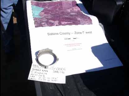
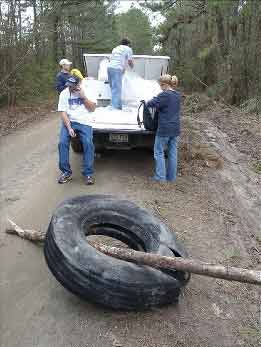
Figure 2.
One of the right-side tires of the Space Shuttle Columbia recovered
near Hemphill, Texas. Shuttle debris locations were mapped using GPS. Maps
were then developed to guide debris recovery efforts and assess hazardous
material. Photo by Stephen C. Brown.
Three Important Lessons Learned
Need for Training
While low-cost recreational GPS receivers are relatively easy to operate, many users are not aware of the technology's complexities. An important lesson learned in the Columbia recovery effort was the need to train personnel in the appropriate use of GPS. Many of the GPS users were not aware that most receivers could easily be toggled between different coordinate system formats. Even a simple 1-hour instruction on how to use a GPS receiver for data collection, navigation, and coordinate system configuration would have saved countless hours in data conversion.
Need for Uniform Mapping Standard
The many different agencies and organizations involved in the recovery often used different mapping standards, which greatly slowed the production of response maps while data conversions were completed. For example, the Texas National Guard uses the Universal Transverse Mercator (UTM) coordinate system, while data available from the Texas Natural Resources Information System (TNRIS) is frequently in state plane coordinates. The U.S. Forest Service generally preferred geographic coordinates for its data collection and navigation. Even within the Forest Service, some preferred coordinates in decimal degrees, while others wanted decimal minutes or even degrees, minutes, seconds.
Varying mapping standards are employed by different agencies and organizations to meet their specific needs. However, during emergencies requiring multi-agency cooperation and collaboration, a previously agreed upon uniform mapping standard establishing map projections, coordinate system formats and map datum can greatly streamline efforts.
Need for Capacity to Print Maps Quickly
Perhaps the most important lesson learned was being prepared with sufficient plotters, network capacity, and memory to print large maps quickly. In the Hemphill section of the recovery effort, approximately 4,000 personnel mobilized each morning to search for debris or recover mapped pieces of the Shuttle. Behind the movements of all these individuals were GIS maps developed from the previous day's data. At any given time, there were 3 to 4 GIS personnel making needed maps to support the recovery efforts.
Unfortunately, for the orthophotographic maps most desired by the search teams, printing was excruciatingly slow. Procurement of the highest speed postscript plotters with expanded memory and onboard print spooling is critical to a successful effort.
Opportunities for Extension
While the Columbia disaster was unique in nature and scope, the lessons learned in the experience reveal a unique opportunity for Extension educators to better prepare state and local agencies for emergency response. These opportunities are as follows.
-
Conduct workshops for local law enforcement, emergency medical personnel, and volunteers in the fundamentals of Global Positioning System receivers.
-
Establish uniform mapping standards among all possible collaborating/cooperating agencies for use during times of emergency. Once these standards are agreed upon, conduct workshops for agency personnel explaining the standards and their importance. Prepare fliers outlining these standards for rapid duplication and distribution during emergency response.
-
Determine organizations willing to provide crucial response equipment such as GPS receivers, computers with GIS software/capability, and high-quality large format printers.
These Extension opportunities are relatively inexpensive to implement, but they could prove invaluable in greatly improving emergency response times. Considering the new emphasis on homeland security, there will likely be significant federal funding available to support such Extension projects. It is currently unknown how many Extension educators have extensive knowledge of GIS/GPS technology. However, this number is likely to be relatively high considering programs such as Integrated Pest Management, precision agriculture, and the National 4-H GIS/GPS Team.
Acknowledgment
The authors would like to acknowledge the contributions of Stephen F. Austin University for providing GIS resources and analysis that supported the entire recovery effort.