October 2001 // Volume 39 // Number 5 // Feature Articles // 5FEA3
Partnering with a National Heritage Corridor: A Connecticut Case Study
Abstract
A local, grass roots effort resulted in the creation of a National Heritage Corridor in northeastern Connecticut and southeastern Massachusetts. The Corridor's mission overlapped with that of the University of Connecticut Cooperative Extension System. By thinking and acting creatively, these two organizations partnered in a way that enhanced the effectiveness of both. The result was a new local Extension education program addressing critical and previously neglected issues and audiences. A needs assessment survey provided crucial information to guide the development of the new education program. The survey results have been and continue to be used to develop the Extension education curriculum and prioritize program offerings.
Introduction: A Heritage Corridor Is Born
In 1988, Connecticut Congressman Sam Gejdenson (D, 2nd District) found that Connecticut ranked last among all 50 states in its amount of federally protected open space. Connecticut was also a distant last among northeastern states in public land available for recreation. (QSHC Advisory Council, 1997).
That same year, a small grassroots organization in northeastern Connecticut called the "Quinebaug Rivers Association" (QRA) began discussing ways to preserve and enhance the natural, cultural, and historic resources in the region. The Quinebaug and Shetucket River watersheds encompass most of the land area of northeastern Connecticut, a traditionally rural region that by the late 1980's was facing development pressure from all directions (Figure 1). The QRA formed a subcommittee called the "Quinebaug-Shetucket Corridor Committee," which began working with state and local agencies on ways to simultaneously promote and protect the unique character of the region. Soon, events such as "Walking Weekend," a 3-day weekend offering dozens of guided walks and hikes, were showcasing the area's history, environment, agriculture, and other unique features.
Original Quinebaug-Shetucket Heritage Corridor
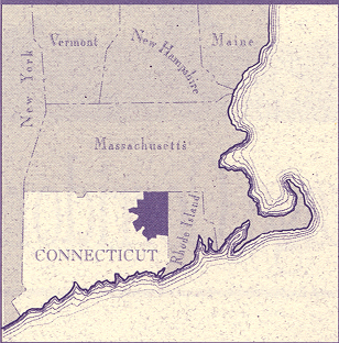
Source: QSHC
In 1988, the National Park Service conducted a study of a 25-town region in northeastern Connecticut bordering the Massachusetts border to the north and Rhode Island to the east. The purpose of the study was to assess the national significance of the region's historic, natural, and cultural resources and their potential for interpretation. Using the information gathered by the National Park Service, the Quinebaug-Shetucket Corridor Committee published three brochures: A Guide to Waterways, A Greenways Vision, and A Driving Tour of Historic Textile Industry Sites.
Then, in 1991, as the Quinebaug-Shetucket Corridor Committee continued to partner with state agencies, non-profits, and citizens groups, Congressman Gejdenson drafted legislation to designate the 25-town region as a National Heritage Corridor. In 1994, the legislation was passed by Congress and signed by the President, making the Quinebaug and Shetucket Rivers Valley National Heritage Corridor the fourth such corridor in the country.
In 1995, the Quinebaug-Shetucket Corridor Committee was incorporated into a non-profit organization, the Quinebaug-Shetucket Heritage Corridor, Inc. (QSHC). In 1996, the QSHC was designated by the Governor Rowland of Connecticut as the official body to manage projects and federal funds. In 1999, additional legislation sponsored by Congressmen Gejdenson and Richard Neal (D, MA 2nd District) expanded the Heritage Corridor to include 35 towns, 9 of which are in Massachusetts (Figure 2).
Expanded Quinebaug-Shetucket Heritage Corridor
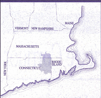
Source: QSHC
What Are National Heritage Corridors?
National Heritage Corridors are innovative entities designed to encourage grassroots efforts to protect and enhance a region's unique natural resources while simultaneously promoting appropriate economic development and redevelopment. Heritage Corridor designation is federal, but the federal government's role is limited to providing technical assistance and interpretation. It does not own or manage any land within the designated corridor. There are currently 18 nationally designated heritage corridors in the country. These corridors coordinate activities and share ideas among themselves through a non-profit organization, the National Alliance of Heritage Areas.
The QSHC has no regulatory authority. The primary role of the Corridor is to "assist in the development and implementation of integrated cultural, historical and recreation land management programs that will retain, enhance, and interpret the significant features of the Corridor" (QSHC Advisory Council, 1997). To fulfill that mission, a long-range management plan was developed that serves as the guiding document for the QSHC. The plan is a synthesis of the goals of the original Heritage Corridor Committee and the federal enabling legislation.
A Unique Educational Partnership
From the outset, Extension educators from the University of Connecticut Cooperative Extension System followed the progress of National Heritage Corridor development closely. Early meetings of the QRA and/or its subcommittee were sometimes held in the county Extension Center, with Extension staff providing periodic limited assistance. Once the Corridor Management Plan was complete, it became clear that the Cooperative Extension System and the QSHC had formal missions that overlapped in several areas, most notably land use and natural resources. Discussions between the two organizations on the best ways to cooperate began in earnest.
By late in 1996, the idea of a jointly funded "Corridor Circuit Rider" position was hatched. The Corridor Circuit Rider (CCR) would be a full-time Extension educator, housed at the local Extension office and jointly funded by the University of Connecticut Cooperative Extension System (CES) and the Quinebaug-Shetucket Heritage Corridor. The CCR would design and implement educational programs in these overlapping mission areas for the 26 Connecticut Corridor towns.
Principal target audiences would include municipal CEOs; planning, zoning, conservation and economic development commissions; and local land trusts. Principal program areas would be land use planning, natural resource conservation, community design, and land protection tools and techniques. In August 1998, the CCR was hired and the partnership was officially underway.
Building a New Program: Target Audience Needs Assessment
The arrival of the CCR marked the first time a local Extension educator was available to address these audiences and program areas since the retirement of the county Community Resource Development (CRD) Agent 15 years earlier. This was, for all practical purposes, a new Extension program in the Corridor region. A diverse group of state and local resource specialists and community leaders was assembled into a Program Advisory Committee, which reached quick agreement that some form of needs assessment was necessary to focus the educational efforts of the new partnership.
In late 1999, the CCR took the lead in drafting a four-page needs assessment survey instrument, which was reviewed for content by the Program Advisory Committee and the QSHC's Natural Resources and Agriculture committee. The revised draft was then pre-tested for clarity by 12 members of the target audience of municipal and land trust leaders.
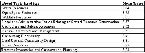
The final survey listed 53 potential continuing education program topics under a number of broad headings (Figure 3). Respondents were asked to rank their interest in each topic on a 1 (not interested) to 5 (very interested) scale. Ample space for additional write-in topics was provided.
Survey Program Topics
|
The survey was mailed in January 1999 to 811 members of municipal planning commissions, zoning commissions, conservation commissions, economic development commissions, inland wetland commissions, historical commissions, Boards of Selectmen, and local land trust boards in the 26 Connecticut Corridor towns. Two hundred eighty-four completed surveys were returned (35% response rate). The results were compiled using Microsoft Access software with assistance from a student of the University of Connecticut Department of Natural Resources Management and Engineering, who received independent study credit for her role in the assessment.
Needs Assessment Results and Discussion
Simple means were calculated for each response topic and category. While differences between means of one or two tenths of a point are unlikely to be statistically significant, considerable insight and guidance may be gained by reviewing the overall response trends. This includes the most and least popular topics and the kinds of topics that consistently appear near the top or bottom of the demand ratings (Tables 1,2, 3). A more complete reporting and discussion of the results is available elsewhere (Broderick, Godin, & Bishop, 1999).
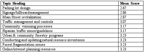
Major Topic Headings with Mean Scores
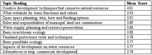
Ten Most In-Demand Specific Topics
Ten Least Demanded Specific Topics
The survey clearly revealed a strong, across-the-board demand for continuing education in natural resources and land use. On a scale of 1 (no interest in the topic) to 5 (great interest in the topic), only 3 of the 53 potential topics (6%) received an average score below the scale midpoint of 3.
Importantly, topics relating to water and wetland resources dominated the program demand list. "Water Resources" was the top-rated general category, and five of the top ten specific program categories were water-related. Following closely behind were open space protection and the planning techniques that accomplish that protection, both at the town and the subdivision levels. "Creative development techniques that conserve open space" was the top-rated topic overall and the only one to average above a 4 on the 1 to 5 scale.
"Wildlife Resources" was the third most popular general topic, followed by "Legal and Administrative Issues Related to Natural Resources". "Computers and Natural Resources" and "Natural Resources/Land Management" tied for the fifth slot.
Overall, the results provided strong evidence to the partnership that quality educational programs and/or materials in the following topic areas would find a large and interested audience:
- Virtually anything related to the functions, values, and protection of wetlands, streams, ponds, and groundwater drinking supplies;
- Alternative development strategies that protect water resources, conserve open space, and/or minimize strip development;
- Tools for protecting open space and farmland, including municipal level planning and creative development techniques;
- Understanding, identifying, protecting, and managing important wildlife habitats and wildlife corridors;
- The roles, responsibilities and optimum interactions among municipal commissions.
At the same time, the results raised at least one significant question: are there cases where a low score is more reflective of ignorance about the topic than a true lack of interest? A few respondents who gave GIS topics a low score, for example, actually wrote in the comments section that they didn't know what it was. Several apparent inconsistencies in the results also provided fodder for this discussion. For example:
- Open space planning and protection was at or near the top of every list. Yet "Conducting and Updating Natural Resource Inventories," an essential prerequisite to a successful municipal open space program, was one of the least popular topics.
- Protection of water quality came through as a clear priority. Yet riparian buffer zone guidelines made the bottom-ten list, and reducing impervious surfaces barely avoided the bottom-ten list.
- Wildlife resources was a top-three general topic. Yet respondents were remarkably uninterested in forest fragmentation, an issue that local wildlife biologists would rank at the top of their issues requiring attention.
Such results suggest that many respondents know what they want, but not what they need. In fact, it is true that most respondents are lay volunteers and likely do not have the background required to understand which specific topics (and action items) are required to address their general concerns.
On the other hand, some respondents may feel they already know enough about open space inventories or may have attended enough impervious surface reduction and/or riparian buffer workshops and so do not need any more information in these areas. Understanding which of these explanations is more prevalent has become an important topic-by-topic investigation issue for CES and the Corridor as program planning proceeds.
Developing the Program
Using the needs assessment results, the partnership began developing and offering a carefully constructed sequence of programs to municipal and land trust volunteer leaders. In May, 2000, the first annual weekend-long retreat, A New Introduction to the Natural World, was held at an overnight camp facility in Woodstock, Connecticut. Its purpose was to provide new lay-volunteers in natural resources a basic background in ecological systems and functions, and the impact of disturbance on those systems.
More than 70 local leaders applied for the 30 available program slots. Through alternating indoor and outdoor sessions and hands-on exercises led by natural resource professionals, attendees learned how bedrock, soils, water, flora, and fauna interact to create the living world. The weekend concluded with a discussion on the roles, responsibilities, and optimum interactions among municipal commissions, and a planning session on how attendees could best put their newly acquired knowledge to work as community volunteers. A 6-month follow-up meeting has been scheduled (at the request of the participants) to assess their progress in implementing those plans.
In July 2000, a 4-day computer laboratory course, Geospatial Technologies at Work: A G.I.S. Training Course for Land Use Decision Makers, was offered at the University of Connecticut's College of Agriculture and Natural Resources. Interestingly, this topic had received a mid-range overall score on the needs assessment, but was at the top of the list of the four largest corridor towns where development pressure is greatest. Through a series of graphic presentations followed by hands-on exercises, attendees were taught the basic functions of ArcView software and how to access and work with publicly available digital data such as roads, soils, surficial geology, watercourses, and satellite-derived land cover. The course was marketed more heavily in the larger communities and filled to capacity both times it was offered.
Future programs designed to address high demand topics include:
- A creative development workshop with land use planner, site designer, award winning author, and nationally acclaimed lecturer Randall Arendt;
- A scenic highway design manual and growth management workshop series;
- A historic village district design workshop; and
- A multi-faceted program on land protection tools and techniques.
Summary and Conclusion
A local, grass roots effort to protect the things that made a region special resulted in the creation of a National Heritage Corridor in northeastern Connecticut and southeastern Massachusetts. The Corridor's mission overlapped with that of the University of Connecticut Cooperative Extension System. By thinking and acting creatively, these two organizations were able to partner in a way that enhanced the effectiveness of both. The result was a new local Extension education program addressing critical and previously neglected issues and audiences.
At this writing, the formal partnership including the CCR has been in place for just over 2 years and is becoming a model for other heritage corridors across the country. The Clemson Cooperative Extension System and the South Carolina National Heritage Corridor partnered this year to create a position based on the Connecticut Corridor Circuit Rider concept.
A needs assessment survey, sent to members of the partnership's priority target audiences, provided crucial information to guide the development of the new education program. The survey results have been and continue to be used to develop the Extension education curriculum and prioritize program offerings. Program evaluations (available from the authors on request) clearly show that this formula for program development, implemented by the new partnership, is getting results. The high turnover rate within the target audiences, and the continual emergence of new natural resource issues and concerns, will make periodic reassessment of these education preferences an important cog in the partnership's long-term efforts.
References
Broderick, S. H., Godin, K. B. and Bishop, A. (1999). Continuing education needs in natural resources, land use and community design. University of Connecticut Cooperative Extension System.
Quinebaug and Shetucket Rivers Valley National Heritage Corridor Advisory Council. (1997). Vision to a reality: A Management plan. Connecticut: Quinebaug-Shetucket Heritage Corridor.